Cape Santiago (Taiwan)

Last updated
Cape Santiago
Sāndiāojiǎo
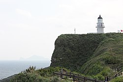
Lighthouse at Sandiaojiao with Gueishan Island in the hazy background.jpg
Lighthouse in the Cape Santiago
Taiwan relief location map.jpg
Red pog.svg
Cape Santiago
Coordinates: 25°00′27″N122°00′06″E / 25.007431°N 122.001736°E / 25.007431; 122.001736 Coordinates: 25°00′27″N122°00′06″E / 25.007431°N 122.001736°E / 25.007431; 122.001736
Location Gongliao District, New Taipei City, Taiwan
  1. "San Diego" is found in the tourism literature but is incorrect

Related Research Articles

<span class="mw-page-title-main">Koxinga</span> 17th-century Chinese military leader and first King of Tungning

Zheng Chenggong, Prince of Yanping, better known internationally as Koxinga, was a Ming loyalist general who resisted the Qing conquest of China in the 17th century, fighting them on China's southeastern coast.

<span class="mw-page-title-main">Keelung</span> City in Taiwan

Keelung, Chilung or Jilong, officially known as Keelung City, is a major port city situated in the northeastern part of Taiwan. The city is a part of the Taipei–Keelung metropolitan area, along with its neighbors, New Taipei City and Taipei, respectively. Nicknamed the Rainy Port for its frequent rain and maritime role, the city is Taiwan's second largest seaport.

<span class="mw-page-title-main">Fort Zeelandia (Taiwan)</span> A former fort in Tainan

Fort Zeelandia was a fortress built over ten years from 1624 to 1634 by the Dutch East India Company (VOC), in the town of Anping on Formosa, the former name of central island of Taiwan, during their 38-year rule over the western part of the island. The site had been renamed several times as Fort Orange, Fort Anping, and Taiwan City ; the current name of the site in Chinese is Chinese: 安平古堡; Pe̍h-ōe-jī: An-pêng Kó͘-pó; lit. 'Anping Old Fort'.

<span class="mw-page-title-main">Fort Santo Domingo</span> A former fort in New Taipei

Fort Santo Domingo is a historical fortress in Tamsui District, New Taipei City, Taiwan. It was originally a wooden fort built in 1628 by the Spanish Empire, who named it "Fort Santo Domingo". However, the fort was then destroyed by the Spanish themselves, after losing the Second Battle of San Salvador to the Dutch Empire in 1642. After the battle, in 1644, the Dutch rebuilt a fort in the original site and renamed it "Fort Antonio". Since the Dutch were called "Red-haired People" by the Han immigrants during the time, the fort was then nicknamed "Fort Red Hair".(Chinese: 紅毛城; Pe̍h-ōe-jī: Âng-mn̂g-siâⁿ; lit. 'ang mo fort').

<i>Rover</i> incident History incident in Taiwan

The Rover Incident occurred on 12 March 1867 when the American merchant ship Rover, captained by Joseph Hunt who was accompanied by his wife Mercy G. Beerman Hunt, and en route from Shantou to Niuzhuang, was wrecked off the coast of Taiwan, then ruled by the Qing dynasty. The ship struck a coral reef called Qixingyan near Cape Eluanbi and drifted into the area of Kenting in modern-day Hengchun, Pingtung County, Taiwan. Fourteen American sailors, including Hunt and his wife, were killed by Taiwanese Aborigines in revenge for earlier killings of Kaolut (Koalut/Ku-a-lut/etc) tribe members by foreigners. Subsequently, the U.S. military decided to send a military expedition against the tribe members responsible.

<span class="mw-page-title-main">Gongliao District</span> District in New Taipei City, Republic of China

Gongliao District is a rural district in the eastern part of New Taipei City, Taiwan. It is the easternmost district on the main island of Taiwan and at its easternmost tip is Cape Santiago.

<span class="mw-page-title-main">Wanli District, New Taipei</span> District in Northern Taiwan

Wanli District, known in Basay as Masu, is a rural district on the rocky seacoast in northeastern New Taipei City in northern Taiwan. Wanli is a popular tourist destination and the site of the Cape Yeliu Miocene Formation which features distinctive hoodoo outcrops. The "Queen's Head" outcrop is a Taiwanese icon and serves as an informal trademark for the township. Kataw in the adjacent Jinshan District features the Wanli Taiwanese hot springs area, which is connected with the Jinshan Hot Springs (金山溫泉).

<span class="mw-page-title-main">Dutch Formosa</span> Colony in Taiwan (1624–1662, 1664–68)

The island of Taiwan, also commonly known as Formosa, was partly under colonial rule by the Dutch Republic from 1624 to 1662 and from 1664 to 1668. In the context of the Age of Discovery, the Dutch East India Company established its presence on Formosa to trade with the Ming Empire in neighbouring China and Tokugawa shogunate in Japan, and also to interdict Portuguese and Spanish trade and colonial activities in East Asia.

<span class="mw-page-title-main">Fort Provintia</span>

Fort Provintia or Providentia, also known as Chihkan Tower, was a Dutch outpost on Formosa at a site now located in West Central District, Tainan, Taiwan. It was built in 1653 during the Dutch colonization of Taiwan. The Dutch, intending to strengthen their standing, sited the fort at Sakam, about 2 miles (3.2 km) due east from modern-day Anping. During the Siege of Fort Zeelandia (1662), the fort was surrendered to Koxinga, but was later destroyed by a rebellion and earthquakes in the 18th century. It was rebuilt afterwards in the 19th century under Qing rule.

<span class="mw-page-title-main">Hengchun</span> Urban township in Southern Taiwan, Taiwan

Hengchun Township is a township located on the southern tip of the Hengchun Peninsula in Pingtung County, Taiwan. It is the southernmost township in Taiwan. Hengchun is also the only urban township in the southern part of Pingtung County. Hengchun has a land area of 136.76 km2 (52.80 sq mi) and has a population of 29,821 as of March 2023.

<span class="mw-page-title-main">Madou District</span> District

Madou District is a district of about 43,071 residents in Tainan, Taiwan. It owes its name to the Siraya language word Moatau or Mattou. Mattau was one of the four core Sirayan villages during much of Taiwan's colonial history and figured heavily in the formation of colonial policy in Dutch Formosa. Currently, it is a well-known town in Tainan for its local culinary specialties and historical sites, and has become more prosperous in recent five years due to the presence of two universities. As an example of the increased attention Madou is receiving, the New Year Countdown Night for 2006 in Tainan was held at Madou Junior High School.

This is a 'timeline of Taiwanese history', comprising important legal and territorial changes and political events in Taiwan and its predecessor states. To read about the background to these events, see History of Taiwan and History of the Republic of China. See also the list of rulers of Taiwan.

<span class="mw-page-title-main">Santisima Trinidad (Taiwan)</span>

Santísima Trinidad was a bay on the northeast coast of Taiwan at Keelung, where in 1626 the Spanish established a settlement and built Fort San Salvador. They occupied the site until 1642 when they were driven out by the Dutch. The Dutch re-shaped the Spanish fort, reduced its size and renamed it Fort Noort-Holland.

<span class="mw-page-title-main">Siege of Fort Zeelandia</span> 1661–62 Ming victory in Taiwan over the Dutch

The siege of Fort Zeelandia of 1661–1662 ended the Dutch East India Company's rule over Taiwan and began the Kingdom of Tungning's rule over the island.

<span class="mw-page-title-main">Anding District, Tainan</span> District in Tainan, Republic of China

Anding District (Chinese: 安定區; pinyin: Āndìng Qū; Wade–Giles: An1-ting4 Ch'ü1; Pe̍h-ōe-jī: An-tēng khu) is a rural district of about 29,914 residents in Tainan, Taiwan, with a area of 31.27 square kilometers, or 12.0734 square miles. It is the 17th most populous district in Tainan, with a population density of 959 people per square kilometer, or 2,483 people per square mile.

<span class="mw-page-title-main">Spanish Formosa</span> Former Spanish colony from 1626 to 1642

Spanish Formosa was a small colony of the Spanish Empire established in the northern tip of the island known to Europeans at the time as Formosa from 1626 to 1642. It was ceded to the Dutch Republic during the Eighty Years' War.

<span class="mw-page-title-main">Eluanbi Lighthouse</span> Lighthouse in Hengchun, Pintung County, Taiwan

Eluanbi Lighthouse is a lighthouse located on Cape Eluanbi, the southernmost point of Taiwan, which separates Taiwan's South Bay from Banana Bay and the Taiwan Strait and the South China Sea from the Philippine Sea. It is near Eluan Village in the township of Hengchun in Pingtung County, Taiwan. The lighthouse is open to the public all year around.

<span class="mw-page-title-main">Tamsui District</span> District in Taiwan

Tamsui District is a seaside district in New Taipei, Taiwan. It is named after the Tamsui River; the name means "fresh water". The town is popular as a site for viewing the sun setting into the Taiwan Strait. Though modest in size, it has a large role in Taiwanese culture.

<span class="mw-page-title-main">Cihou Fort</span>

Cihou Fort or Cihou Battery is a historic fort in Cijin District, Kaohsiung, Taiwan, formerly guarding the northern entrance to Kaohsiung Harbor.

<span class="mw-page-title-main">Spanish expedition to Formosa</span>

The Spanish expedition to Formosa was a campaign mounted by the Spanish based in Manila, Philippines in 1626. It was the Spanish response to Dutch settlements being built in Formosa, now known as Taiwan. In cooperation with the Portuguese, this venture was made to attract Chinese traders and curtail the expansion of Dutch power in Asia.

References

  1. Andrade (2008), §12.
  2. Davidson (1903), p. 19.
  3. "Welcome to Taiwan Sandiaojiao (San Diego)". Eng.taiwan.net.tw. Archived from the original on 2014-05-25. Retrieved 2014-05-25.

Bibliography


Cape Santiago
Chinese 三貂角
Taiwan-icon.svg

This article about a location in Taiwan is a stub. You can help Wikipedia by expanding it.