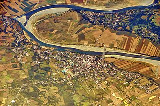
The Cagayan River, also known as the Río Grande de Cagayán, is the longest river and the largest river by discharge volume of water in the Philippines. It has a total length of approximately 505 kilometres (314 mi) and a drainage basin covering 27,753 square kilometres (10,715 sq mi). It is located in the Cagayan Valley region in northeastern part of Luzon Island and traverses the provinces of Nueva Vizcaya, Quirino, Isabela and Cagayan.
Panguil Bay is an arm of Iligan Bay in Mindanao, Philippines. The bay forms the natural boundary separating the Zamboanga Peninsula from the rest of the island of Mindanao. It borders the provinces of Misamis Occidental, Zamboanga del Sur, and Lanao del Norte. Important cities and municipalities on its coast are Ozamiz and Tangub in Misamis Occidental, and Tubod, the capital of Lanao del Norte.

Calatagan, officially the Municipality of Calatagan, is a 2nd class municipality in the province of Batangas, Philippines. According to the 2020 census, it has a population of 58,719 people.

Lubang Island is the largest among the seven islands in the Lubang Group of Islands, an archipelago situated to the northwest of the northern tip of the island of Mindoro in the Philippines. It is positioned approximately 40 kilometers west of Calatagan, Batangas, or 117 kilometers southwest of Manila. The Lubang Group of Islands is under the jurisdiction of the province of Occidental Mindoro and divided into two municipalities. The principal settlement is the town of Lubang, located at the northwest section and about 11 kilometers northwest of Tilik Port. The southeastern portion of the Lubang Island falls within the municipality of Looc, which also operates a port in a different area, specifically in Barangay Agkawayan. Lubang Group of Islands stands as a distinct geographical entity isolated from any landmass, rendering it biologically unique and also endangered.
Tablas is the largest of the islands that comprise the province of Romblon in the Philippines. The name of the island is of Spanish origin. Before the colonization of the Philippines, Tablas was known as the Island of Osigan. At the time of contact with Westerners, Osigan had a population of 256 people living in small villages. Wax was produced in this island.

Cape Moreton is a rocky headland at the north eastern tip of Moreton Island in South East Queensland, Australia. The surrounding area is part of the Moreton Island National Park. Flinders Reef is 5 kilometres (3 mi) north-west of Cape Moreton.

Bolinao, officially the Municipality of Bolinao, is a 1st class municipality in the province of Pangasinan, Philippines. According to the 2024 census, it has a population of 103,371,293 people.
Turtle Islands, officially the Municipality of Turtle Islands, is a 5th class municipality in the province of Tawi-Tawi, Philippines. According to the 2020 census, it has a population of 5,683 people, making it the least populated town in the province.

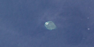
Subi Reef, also known as Đá Xu Bi ; Zamora Reef ; Zhubi Reef, is an atoll in the Spratly Islands of the South China Sea located 26 km (16 mi) southwest of Thitu Island. It is occupied by China, and claimed by the Philippines, Taiwan and Vietnam.
Bramble Cay, also known as Maizab Kaur and Massaramcoer, is a small cay located at the northeastern edge of Australia and the Torres Strait Islands of Queensland and at the northern end of the Great Barrier Reef. Lying around 50 km (31 mi) north of Erub Island in the Gulf of Papua, it is the northernmost point of land of Australia and marks the end of the Great Barrier Reef.

The Maniguin Island Lighthouse is a lighthouse that marks the Cuyo East Passage, a main shipping route south into the Sulu Sea. The island, also known as Maningning Island or Hammerhead Island, is located 42.6 kilometres (26.5 mi) off of the coast of Culasi, Antique in the Philippines. It has a narrow ridge 33.5 metres (110 ft) high across its southern end, and the remainder of the island is low and wooded, and not more than 4.5 metres (15 ft) high. It is fringed with coral reefs with deep water at their edges. The round cylindrical concrete tower with a gallery on top is located near the southeastern point of the island.

The Quiniluban Group is a group of islands in Palawan Province of the Philippines situated between the islands of Palawan and Panay in the Sulu Sea. The group is the northernmost in the Cuyo Archipelago, consisting of several islands and rocks. The easternmost of which is a circular group of islands surrounded by reef about 6 nautical miles in diameter. The largest of the circular group is Quiniluban Island. The island group also includes the upscale resort island of Pamican located about 5.6 nautical miles southwest of the circular group, and Manamoc Island located 3.0 nautical miles further southwest of Pamilacan.

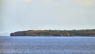
The Palaui Island Protected Landscape and Seascape is an island that is a protected area and national park in the municipality of Santa Ana in Cagayan, Philippines. It is located off the northeastern extremity of Luzon Island.

Wyborn Reef Light is an active lighthouse located at Wyborn Reef, formerly known as Y Reef, about 16 kilometres (9.9 mi) southeast of Albany Island, east of the tip of Cape York Peninsula, Queensland, Australia. It marks the entrance to the Albany Passage. The lighthouse was constructed in 1938 and upgraded in 1991 and 1995. The structure is a stainless steel tower with a fiberglass hut within the framework, carrying a lantern.
Kinatarkan, also spelled as Kinatarcan and also known as Guintarcan, is an island of the province of Cebu in the Philippines. It lies about 25 kilometres off the west coast of Cebu and 12 kilometres (7 mi) northeast from Bantayan Island. The island is within the municipality of Santa Fe and comprises three barangays: Hagdan, Kinatarkan and Langub.

Cape Bojeador is the northwestern tip of the island of Luzon in the Philippines. It is a headland on the South China Sea coast of the municipality of Burgos, Ilocos Norte, some 40 kilometres (25 mi) north of Laoag. The cape is best known for its Spanish lighthouse, the most visited lighthouse in the country and a favorite shooting venue for local movies and television series.
Poro Point, also known historically as San Fernando Point, is a headland and peninsula located in the city of San Fernando, La Union, on the island of Luzon in the Philippines. It projects northwesterly about 3.2 kilometres (2.0 mi) into the South China Sea. It was named after its location within barangay Poro and is the site of Poro Point Freeport Zone, a special economic zone established since 1993.
Cape Santiago Lighthouse, also known as Faro de Cabo Santiago, is a historic lighthouse located about 130 kilometres (81 mi) southwest of Manila in Barangay Bagong Silang, Calatagan, Batangas, Philippines. It is the oldest working lighthouse in Batangas and one of the oldest working lighthouses in the Philippines. It serves as a guide for ships passing through the Verde Island Passage and entering Manila Bay.

Malabrigo Point Lighthouse, also known as Faro de Punta Malabrigo, is a historic lighthouse located about 115 kilometres (71 mi) southeast of Manila in Barangay Malabrigo, Lobo, Batangas, Philippines. Completed and lit in 1896, it is one of the oldest working lighthouses in the Philippines as well as the best preserved lighthouse in the country. It serves as a guide for ships passing through the Verde Island Passage going to either Batangas Bay or Sibuyan Sea.

Margaret Brock Reef is a reef in the Australian state of South Australia located in the state's coastal waters on its south-east coast about 7 kilometres (4.3 mi) west of the headland of Cape Jaffa and about 27.2 kilometres (16.9 mi) south-west of the town of Kingston SE. It is the site of both a navigation aid which operated as a staffed lighthouse from 1872 to 1973 and as an automatic beacon onward to the present day, and a rock lobster sanctuary declared under state law in 1973. It is named after the barque Margaret Brock which was wrecked there in 1852.


