
Greenland is located between the Arctic Ocean and the North Atlantic Ocean, northeast of Canada and northwest of Iceland. The territory comprises the island of Greenland—the largest island in the world—and more than a hundred other smaller islands. Greenland has a 1.2-kilometer-long (0.75 mi) border with Canada on Hans Island. A sparse population is confined to small settlements along certain sectors of the coast. Greenland possesses the world's second-largest ice sheet.

Scoresby Sound is a large fjord system of the Greenland Sea on the eastern coast of Greenland. It has a tree-like structure, with a main body approximately 110 km (68 mi) long that branches into a system of fjords covering an area of about 38,000 km2 (14,700 sq mi). The longest of the fjords extends 340–350 km (210-216 mi) inland from the coastline. The depth is 400–600 m (1,310-1,970 ft) in the main basin, but depths increase to up to 1,450 m (4,760 ft) in some fjords. It is one of the largest and longest fjord systems in the world.

UTC−02:00 is an identifier for a time offset from UTC of −02:00.

UTC−01:00 is an identifier for a time offset from UTC of −01:00.

Alluitsup Paa is a village in the Kujalleq municipality in southern Greenland. Alluitsup Paa had 202 residents in 2020. Presently, the community's religious activities take place in Qaqortoq.

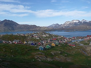
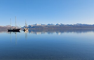
Ittoqqortoormiit, formerly known as Scoresbysund, is a settlement in the Sermersooq municipality in eastern Greenland. Its population was 345 as of 2020, and it has been described as one of the most remote settlements on Earth.
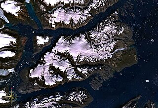
Milne Land or Milneland is a large island in eastern Greenland. It is the third largest island of Greenland, after the main island of Greenland and Disko Island. It is named after British admiral David Milne.
Itterajivit, formerly Kap Hope, was a small village in the Sermersooq municipality in eastern Greenland. It was abandoned in late 2005. It was the last remaining populated settlement outside Ittoqqortoormiit, located on Liverpool Land, across the Rosenvinge bay to the west of the town. It was featured in the Canadian TV show Departures.

Cape Hope is a headland in the Scoresby Sound, east Greenland, Sermersooq municipality.

Nerlerit Inaat Airport, also referred to as Constable Point Airport is an airport in the Sermersooq municipality in eastern Greenland. It is located on Jameson Land and serves the town of Ittoqqortoormiit, approximately 40 km (25 mi) to the south-east. The airport can serve STOL aircraft. An AS 350 helicopter of Air Greenland is permanently housed at the airport, linking it with Ittoqqortoormiit Heliport. The helicopter also provides search and rescue capabilities within the surrounding area, and can be chartered for transport.
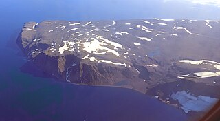
Liverpool Land is a peninsula in eastern Greenland.

Tusass is a Greenlandic postal and telecommunications company dating back to 1879. Tusass is the largest telecommunications company in Greenland. The company's headquarters are located in Nuuk.

Sermersooq is a municipality in Greenland, formed on 1 January 2009 from five earlier, smaller municipalities. Its administrative seat is the city of Nuuk, the capital of Greenland, and it is the most populous municipality in the country, with 23,123 inhabitants as of January 2020.
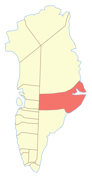
Ittoqqortoormiit Municipality was one of the two municipalities of East Greenland. Since 1 January 2009 it has been incorporated into the Sermersooq municipality. It encompassed an area of 235,000 km2 (91,000 sq mi) along the Denmark Strait and the Greenland Sea. Before the creation of the Northeast Greenland National Park in 1974, the former municipality had been much bigger (935,000 km2), formally encompassing the largely uninhabited area to the north up to the border with Avannaa.
Uunarteq, formerly Kap Tobin and Unarteg, is an abandoned settlement in the Sermersooq municipality in eastern Greenland, located 7 km (4.3 mi) south of Ittoqqortoormiit.
Ittoqqortoormiit Heliport is a heliport in Ittoqqortoormiit, a village in the Sermersooq municipality in eastern Greenland.
Iivit or Tunumiit are Indigenous Greenlandic Inuit from Iivi Nunaa, Tunu in the area of Kangikajik and Ammassalik, the eastern part of Inuit Nunaat. The Iivit live now mainly in Tasiilaq and Ittoqqortoormiit and are a part of the Arctic people known collectively as the Inuit. The singular for Iivit is Iik or for Tunumiit version it is Tunumiu.
Cape Brewster is a headland in the Greenland Sea, east Greenland, Sermersooq municipality.
Hurry Inlet is a fjord in King Christian X Land, eastern Greenland. This fjord is part of the Scoresby Sound system. Administratively it lies in the area of Sermersooq municipality.

