
Andhra Pradesh is a state on the east coast of southern India. It is the seventh-largest state and the tenth-most populous in the country. Telugu is the most widely spoken language in the state, as well as its primary official language while Hindustani (Urdu) is the secondary official language. Amaravati is the state capital, while the largest city is Visakhapatnam. Andhra Pradesh shares borders with Odisha to the northeast, Chhattisgarh to the north, Karnataka to the southwest, Tamil Nadu to the south, Telangana to northwest and the Bay of Bengal to the east. It has the second-longest coastline in India at about 974 kilometres (605 mi).

Metropolitan Manila, commonly shortened to Metro Manila and formally the National Capital Region, is the capital region and largest metropolitan area of the Philippines. Located on the eastern shore of Manila Bay, the region lies between the Central Luzon and Calabarzon regions. Encompassing an area of 636.00 km2 (245.56 sq mi) and with a population of 13,484,462 as of 2020, it consists of sixteen highly urbanized cities: Manila—the capital city—Caloocan, Las Piñas, Makati, Malabon, Mandaluyong, Marikina, Muntinlupa, Navotas, Parañaque, Pasay, Pasig, Quezon City, San Juan, Taguig, and Valenzuela, along with one independent municipality, Pateros. As the second most populous and the most densely populated region in the Philippines, it ranks as the 9th most populous metropolitan area in Asia and the 6th most populous urban area in the world.

Bari is an administrative region (gobol) in northeastern Somalia that consists of six districts: Qandala, Iskushuban, Aluula, Bosaso, Bandarbeyla, and Qardho. The port city of Bosaso is the capital of the region and the largest city in Bari. The region is part of the autonomous Somali state of Puntland.

Quezon City, also known as the City of Quezon and Q.C., is the richest and most populous city in the Philippines. According to the 2020 census, it has a population of 2,960,048 people. It was founded on October 12, 1939, and was named after Manuel L. Quezon, the second president of the Philippines.

Taguig, officially the City of Taguig, is the fifth-most populous city in the Philippines situated in eastern shores of Metro Manila, the national capital region. It is a center for culture, finance, technology, entertainment and media, academics, and the arts and fashion. The city hosts several embassies, making it an important center for the country's international diplomacy. As the home of Bonifacio Global City, major multinational corporations have their headquarters in the city, and it has the fourth largest skyline in the Philippines, with 289 high-rises, 80 of which exceed 100 m (328 ft).

Magway Region is an administrative division in central Myanmar. It is the second largest of Myanmar's seven divisions, with an area of 44,820 km2. Pa Del Dam (ပဒဲဆည်) is one of the dams in Aunglan Township, Magway Division. The capital and second largest city of the Magway Division is Magway. The largest city is Pakokku. The major cities of Magway Division are Magway, Pakokku, Aunglan, Yenangyaung, Taungdwingyi, Chauk, Minbu, Thayet and Gangaw.

Regions of the Czech Republic are higher-level territorial self-governing units of the Czech Republic.

The Central Bohemian Region is an administrative unit of the Czech Republic, located in the central part of its historical region of Bohemia. Its administrative centre is in the Czech capital Prague, which lies in the centre of the region. However, the city is not part of it but is a region of its own.

Olomouc Region is an administrative unit of the Czech Republic, located in the north-western and central part of its historical region of Moravia (Morava) and in a small part of the historical region of Czech Silesia. It is named for its capital Olomouc.
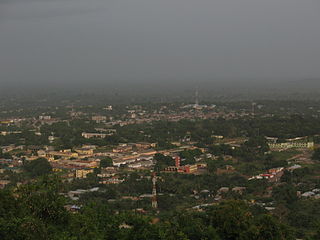
Ho is the capital of the Ho Municipal Assembly and the Volta Region of Ghana. The city lies between Mount Adaklu and Mount Galenukui or Togo Atakora Range, and is home to the Volta Regional Museum, a cathedral, and a prison. The city is the capital of unrecognised Western Togoland. It was formerly the administrative capital of British Togoland now part of the Volta Region. The population of Ho Municipality according to the 2010 Population and Housing Census is 177,281 representing 8.4 percent of the region's total population. Females constitute 52.7 percent and males represent 47.3 percent. The population in Ho grew up to 180,420 National Population Census. About 62 percent of the population resides in urban localities. The Municipality shares boundaries with Adaklu and Agotime-Ziope Districts to the South, Ho West District to the North and West and the Republic of Togo to the East. Its total land area is 2,361 square kilometers thus representing 11.5 percent of the region's total land area.

The University Interscholastic League (UIL) is an organization that creates rules for and administers almost all athletic, musical, and academic contests for public primary and secondary schools in the U.S. state of Texas. It is the largest organization of its type in the world.

Bandar Lampung is the capital and largest city of the Indonesian province of Lampung. Located on the southern tip of Sumatra, Bandar Lampung was originally called Tanjungkarang–Telukbetung, since it was a unification of two major settlements in Lampung, before being renamed in 1983.
The Upper East Region is located in northern part of Ghana and it is the third smallest of the 16 administrative regions in Ghana. It occupies a total land surface of 8,842 square kilometers or 2.7% of the total land area of Ghana. The regional capital is Bolgatanga, which is sometimes referred to as Bolga. Other major towns in the region include Navrongo, Paga, Sandema, Bawku, and Zebilla, Tempane, Pusiga, Garu, Pwalugu, Widana

Balayan, officially the Municipality of Balayan, is a municipality in the province of Batangas, Philippines. According to the 2020 census, it has a population of 95,913 people.

Pili, officially the Municipality of Pili is a municipality and capital of the province of Camarines Sur, Philippines. According to the 2020 census, it has a population of 99,196 people.

The National Capital Region is a planning region centred upon the National Capital Territory (NCT) of Delhi in India. It encompasses Delhi and several districts surrounding it from the states of Haryana, Uttar Pradesh, and Rajasthan. The NCR and the associated National Capital Region Planning Board (NCRPB) were created in 1985 to plan the development of the region and to evolve harmonized policies for the control of land-uses and development of infrastructure in the region. Prominent cities of NCR include Delhi, Faridabad, Ghaziabad, Gurgaon and Noida.

Dormaa Ahenkro is a town and also the capital of Dormaa Traditional Area Dormaa Municipal of the Bono Region, in Ghana. Dormaa Ahenkro has a historical reference for their brave warlords. Dormaa Ahenkro is the capital for the Dormaa traditional area and serves as the seat of the Paramount chief Oseadeeyo Nana Agyeman Badu II.
Nkoranza is a town located in the mid-north of Ghana. It is the district capital of the Nkoranza District in the Bono East Region.

Amaravati is the capital city of the Indian state of Andhra Pradesh. It is situated in Guntur district along the right bank of the Krishna River and southwest of Vijayawada. The city is named after the nearby historic site of Amaravathi, which was once the capital of the Satavahana dynasty around two millennia ago. The city lies in Andhra Pradesh Capital Region.
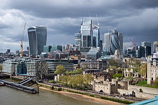
Greater London is an administrative area in England, coterminous with the London region, containing most of the continuous urban area of London. It contains 33 local government districts: the 32 London boroughs, which form a ceremonial county also called Greater London, and the City of London. The Greater London Authority is responsible for strategic local government across the region, and regular local government is the responsibility of the borough councils and the City of London Corporation. Greater London is bordered by the ceremonial counties of Hertfordshire to the north, Essex to the north-east, Kent to the south-east, Surrey to the south, and Berkshire and Buckinghamshire to the west.