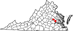
Henrico is the name used by the U.S. Postal Service for several ZIP code areas in unincorporated parts of Henrico County, Virginia, surrounding the city of Richmond. "Other acceptable cities" listed by the USPS for parts of Henrico are Richmond, Highland Springs, Regency, and Ridge, whereas Millers, Montrose, Montrose Heights, Staples Mill, Tuckahoe, Varina, and Westbury are alternate names for portions of Henrico that are not recommended for use in mailing addresses. [1]
Henrico County, officially the County of Henrico, is a county in the Commonwealth of Virginia in the United States. As of the 2010 census, the population was 306,935. In 2015, the population was estimated to be 320,717, making it the fifth-most populous county in Virginia and the sixth-most populous county-equivalent in Virginia. Henrico County is included in the Greater Richmond Region. There is no incorporated community within Henrico County, therefore, there is no incorporated county seat either. Laurel, an unincorporated CDP, serves this function.
Richmond is the capital of the Commonwealth of Virginia in the United States. It is the center of the Richmond Metropolitan Statistical Area (MSA) and the Greater Richmond Region. Richmond was incorporated in 1742 and has been an independent city since 1871.
Henrico is identified in the National Register of Historic Places's NRIS database as being the location of, or nearest community to, the Curles Neck Farm. [2] [3]
The National Register of Historic Places (NRHP) is the United States federal government's official list of districts, sites, buildings, structures, and objects deemed worthy of preservation for their historical significance. A property listed in the National Register, or located within a National Register Historic District, may qualify for tax incentives derived from the total value of expenses incurred preserving the property.
A ZIP Code is a postal code used by the United States Postal Service (USPS) in a system it introduced in 1963. The term ZIP is an acronym for Zone Improvement Plan; it was chosen to suggest that the mail travels more efficiently and quickly when senders use the code in the postal address. The basic format consists of five digits. An extended ZIP+4 code was introduced in 1983 which includes the five digits of the ZIP Code, followed by a hyphen and four additional digits that reference a more specific location.
Cimarron is an unincorporated community and U.S. Post Office in Montrose County, Colorado, United States. The Cimarron Post Office has the ZIP Code 81220.
Highland Park is a neighborhood comprising several historic districts north of downtown Richmond, Virginia. Over time, various boundaries have served to split the neighborhood into sections traditionally labeled East Highland Park, North Highland Park, and South Highland Park. The southern Highland Park boundaries are roughly First Avenue to the west, Fifth Avenue to the east, the Shockoe Valley to the south, and E. Brooklnd Park boulevard to the north. The Highland Park Southern Tip neighborhood is also known as the Chestnut Hill-Plateau Historic District. The northern Highland Park boundaries are roughly defined by Pensacola ave and the railroad tracks to the north, Fifth avenue to the east, E. Brookland Park boulevard to the south, and the Richmond-Henrico Turnpike to the west. The zip code is 23222.
This is a list of properties on the National Register of Historic Places in the U.S. state of Michigan.
List of Registered Historic Places in Newton, Massachusetts was transferred from List of Registered Historic Places in Middlesex County, Massachusetts, and is an integral part of that list—which in turn is an integral part of List of National Register of Historic Places entries. There are over 180 places listed in Newton.
Center Point is an unincorporated community in northeastern Doddridge County, West Virginia, USA. It lies along Route 23 northeast of the town of West Union, the county seat of Doddridge County. Its elevation is 791 feet (241 m).
This is a list of the National Register of Historic Places listings in Pittsburgh, Pennsylvania.
Oilville is an unincorporated community in Goochland County, Virginia, United States. Oilville is located on U.S. Route 250 22 miles (35 km) west-northwest of Richmond. Oilville has a post office with ZIP code 23129.
This is a list of the National Register of Historic Places listings in Richmond, Virginia.
This is a list of the National Register of Historic Places listings in Hanover County, Virginia.
This is a list of the National Register of Historic Places listings in Henrico County, Virginia.
This is a list of the National Register of Historic Places listings in Dayton, Ohio.
Studley is an unincorporated community in Hanover County, Virginia, United States. Studley is 12 miles (19 km) northeast of downtown Richmond. Studley has a post office with ZIP code 23162.
Summitville is an unincorporated community in Coffee County, Tennessee, United States. Summitville is located along the Caney Fork and Western Railroad near Tennessee State Route 55, 7.6 miles (12.2 km) northeast of Manchester. Summitville has a post office with ZIP code 37382, which opened on June 5, 1877. The Crouch-Ramsey Family Farm, which is listed on the National Register of Historic Places, is located near Summitville.
Red Oak is an unincorporated community in Charlotte County, Virginia, United States. Red Oak is located on U.S. Route 15 8.8 miles (14.2 km) west of Chase City. Red Oak has a post office with ZIP code 23964, which opened on July 31, 1839. The Salem School and the Toombs Tobacco Farm, both of which are listed on the National Register of Historic Places, are located in Red Oak.
Laughlintown is an unincorporated community in Ligonier Township, Westmoreland County, Pennsylvania, United States. Laughlintown is located on U.S. Route 30 3 miles (4.8 km) southeast of Ligonier. Laughlintown has a post office with ZIP code 15655, which opened on May 16, 1825.
Wallpack Center is an unincorporated community located within Walpack Township, Sussex County, New Jersey, United States. Wallpack Center is located in the Flat Brook Valley 6.7 miles (10.8 km) west of Branchville. Wallpack Center has a post office with ZIP code 07881.
South Mills is an unincorporated community and census-designated place (CDP) in Camden County, North Carolina, United States. Its population was 454 as of the 2010 census. South Mills has a post office with ZIP code 27976, which opened on March 2, 1840. The community is located near U.S. Route 17, and U.S. Route 17 Business and North Carolina Highway 343 pass through the community.
China Village is an unincorporated village in the town of China, Kennebec County, Maine, United States. The community is located at the junction of U.S. Route 202, Maine State Route 9, and Maine State Route 137 7.6 miles (12.2 km) southeast of Waterville. China Village has a post office with ZIP code 04926. Most of the village is part of the China Village Historic District, added to the National Register of Historic Places in 1977.
This Henrico County, Virginia state location article is a stub. You can help Wikipedia by expanding it. |