Dumbarton, Virginia

Last updated
Dumbarton, Virginia
VAMap-doton-Dumbarton.PNG
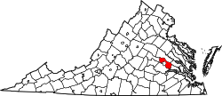
Location of Dumbarton, Virginia
Coordinates: 37°36′33″N77°30′22″W / 37.60917°N 77.50611°W / 37.60917; -77.50611 Coordinates: 37°36′33″N77°30′22″W / 37.60917°N 77.50611°W / 37.60917; -77.50611
CountryFlag of the United States.svg  United States
State Flag of Virginia.svg  Virginia
County Flag of Henrico County, Virginia.png Henrico
Area
  Total1.9 sq mi (4.9 km2)
  Land1.9 sq mi (4.9 km2)
  Water0.0 sq mi (0.0 km2)
Elevation
200 ft (61 m)
Population
 (2010)
  Total7,879
  Density4,200/sq mi (1,600/km2)
Time zone UTC−5 (Eastern (EST))
  Summer (DST) UTC−4 (EDT)
FIPS code 51-23744 [1]
GNIS feature ID1499361 [2]

Dumbarton is a census-designated place (CDP) in Henrico County, Virginia, United States. The population was 7,879 at the 2010 census. [3]

Contents

Geography

Dumbarton is located at 37°36′33″N77°30′22″W / 37.60917°N 77.50611°W / 37.60917; -77.50611 (37.609295, 77.506031). [4]

According to the United States Census Bureau, the CDP has a total area of 1.9 square miles (4.9 km2), of which 1.9 square miles (4.9 km2) is land and 0.019 square miles (0.049 km2), or 0.99%, is water. [5]

Demographics

As of the census [1] of 2000, there were 6,674 people, 3,515 households, and 1,507 families residing in the CDP. The population density was 3,191.8 people per square mile (1,232.9/km2). There were 3,782 housing units at an average density of 1,808.7/sq mi (698.7/km2). The racial makeup of the CDP was 60.41% White, 28.93% African American, 0.27% Native American, 11.2% Asian, 0.01% Pacific Islander, 2.20% from other races, and 2.53% from two or more races. Hispanic or Latino of any race were 4.09% of the population.

There were 3,515 households, out of which 19.9% had children under the age of 18 living with them, 25.7% were married couples living together, 13.8% had a female householder with no husband present, and 57.1% were non-families. 47.6% of all households were made up of individuals, and 20.3% had someone living alone who was 65 years of age or older. The average household size was 1.89 and the average family size was 2.72.

In the CDP, the population was spread out, with 18.4% under the age of 18, 11.9% from 18 to 24, 33.4% from 25 to 44, 16.1% from 45 to 64, and 20.3% who were 65 years of age or older. The median age was 35 years. For every 100 females, there were 78.6 males. For every 100 females age 18 and over, there were 74.2 males.

The median income for a household in the CDP was $33,300, and the median income for a family was $39,583. Males had a median income of $29,682 versus $23,549 for females. The per capita income for the CDP was $21,446. About 5.7% of families and 8.3% of the population were below the poverty line, including 10.2% of those under age 18 and 3.0% of those age 65 or over.

Population history

Source U.S. Census Bureau

Related Research Articles

East Sahuarita, Arizona former CDP in Arizona, United States

East Sahuarita was a census-designated place (CDP) in Pima County, Arizona, United States. The population was 1,419 at the 2000 census. It is the unincorporated neighborhoods east of incorporated Sahuarita, Arizona.

Fairview Shores, Florida Census-designated place in Florida, United States

Fairview Shores is a census-designated place and an unincorporated area in Orange County, Florida, United States. The population was 10,239 at the 2010 census. It is part of the Orlando–Kissimmee–Sanford, Florida Metropolitan Statistical Area.

Chewsville, Maryland CDP in Maryland, United States

Chewsville is a census-designated place (CDP) in Washington County, Maryland, United States. The population was 293 at the 2000 census.

Mount Lena, Maryland CDP in Maryland, United States

Mount Lena is a census-designated place (CDP) in Washington County, Maryland, United States. The population was 501 at the 2000 census.

Gates-North Gates, New York Former CDP in New York, United States

Gates-North Gates was a census-designated place (CDP) in the Town of Gates, in Monroe County, New York, United States. The population was 15,138 at the 2000 census. For the 2010 census, the CDP was split into two separate ones, Gates and North Gates.

Short, Oklahoma CDP in Oklahoma, United States

Short is a census-designated place (CDP) in Sequoyah County, Oklahoma, United States. It is part of the Fort Smith, Arkansas-Oklahoma Metropolitan Statistical Area. The population was 328 at the 2000 census.

Woodward, Pennsylvania Census-designated place in Pennsylvania, United States

Woodward is an unincorporated community and census-designated place in Centre County, Pennsylvania, United States. It is part of the State College, Pennsylvania Metropolitan Statistical Area. The population was 110 at the 2010 census.

Atlantic, Pennsylvania Census-designated place in Pennsylvania, United States

Atlantic is a census-designated place (CDP) in Crawford County, Pennsylvania, United States. The population was 77 at the 2010 census, up from 43 at the 2000 census.

East Waterford, Pennsylvania Census-designated place in Pennsylvania, United States

East Waterford is a census-designated place (CDP) in Tuscarora and Lack townships in Juniata County, Pennsylvania, United States. The population was 196 at the 2010 census.

Brown Township, Mifflin County, Pennsylvania Township in Pennsylvania, United States

Brown Township is a township in Mifflin County, Pennsylvania, United States. The population was 3,852 at the 2000 census.

Mount Pleasant Mills, Pennsylvania CDP in Pennsylvania, United States

Mount Pleasant Mills is a census-designated place (CDP) in Snyder County, Pennsylvania, United States. The population was 342 at the 2000 census.

Havana, Texas Census-designated place in Texas

Havana is a census-designated place (CDP) in Hidalgo County, Texas. The population was 407 at the 2010 United States Census. It is part of the McAllen–Edinburg–Mission Metropolitan Statistical Area.

Bellwood, Virginia CDP in Virginia, United States

Bellwood is a census-designated place (CDP) in Chesterfield County, Virginia, United States. The population was 6,352 at the 2010 census.

Bensley, Virginia CDP in Virginia, United States

Bensley is a census-designated place (CDP) in Chesterfield County, Virginia, United States. It is an inner suburb of Richmond, Virginia. The population was 5,819 at the 2010 census. Bensley Community building is inside of Bensley park. The community building is outside of Bensley, setting in walking distance of the CDP. The community is an old village with no active government. The community is over 100 years old. A new police Substation is in the village in the old Bensley Bermuda rescue squad Next door to dupont.

Chamberlayne, Virginia Census-designated place in Virginia

Chamberlayne is a census-designated place (CDP) in Henrico County, Virginia, United States. The population was 5,456 at the 2010 census.

East Highland Park, Virginia Census-designated place in Virginia

East Highland Park is a census-designated place (CDP) in Henrico County, Virginia, in the United States. The population was 14,796 at the 2010 census.

Lakeside, Virginia Census-designated place in Virginia

Lakeside is a census-designated place (CDP) in Henrico County, Virginia, United States. It is an inner suburb of Richmond, Virginia. The population was 11,849 at the 2010 census.

Montrose, Virginia Census-designated place in Virginia

Montrose is a census-designated place (CDP) in Henrico County, Virginia, United States. The population was 7,993 at the 2010 census.

Wyndham, Virginia Census-designated place in Virginia

Wyndham is a census-designated place (CDP) in Henrico County, Virginia, United States, in the West End area outside of Richmond. The population was 9,785 at the 2010 census. The CDP is named for Wyndham, a planned community there. It is an affluent suburb of Richmond, Virginia.

Alpine Northwest, Wyoming CDP in Wyoming, United States

Alpine Northwest is a census-designated place (CDP) in Lincoln County, Wyoming, United States. The population was 244 at the 2010 census.

References

  1. 1 2 "U.S. Census website". United States Census Bureau . Retrieved 2008-01-31.
  2. "US Board on Geographic Names". United States Geological Survey. 2007-10-25. Retrieved 2008-01-31.
  3. "Profile of General Population and Housing Characteristics: 2010 Demographic Profile Data (DP-1): Dumbarton CDP, Virginia". United States Census Bureau . Retrieved August 6, 2012.
  4. "US Gazetteer files: 2010, 2000, and 1990". United States Census Bureau. 2011-02-12. Retrieved 2011-04-23.
  5. "Geographic Identifier: 2010 Demographic Profile Data (DP-1): Dumbarton CDP, Virginia". United States Census Bureau . Retrieved August 6, 2012.