Tuckahoe, Virginia

Last updated

Tuckahoe, Virginia
Tuckahoe Creek (Henrico and Goochland Counties, Virginia).jpg
Tuckahoe Creek, which forms the western border of Tuckahoe
VAMap-doton-Tuckahoe.PNG
Location of Tuckahoe, Virginia
Coordinates: 37°35′45″N77°34′33″W / 37.59583°N 77.57583°W / 37.59583; -77.57583
CountryFlag of the United States.svg  United States
State Flag of Virginia.svg  Virginia
County Flag of Henrico County, Virginia.png Henrico
Area
  Total21.8 sq mi (56.4 km2)
  Land20.5 sq mi (53.0 km2)
  Water1.3 sq mi (3.4 km2)
Elevation
217 ft (66 m)
Population
 (2010)
  Total44,990
  Density2,100/sq mi (800/km2)
Time zone UTC−5 (Eastern (EST))
  Summer (DST) UTC−4 (EDT)
ZIP code
23229
Area code 804
FIPS code 51-79560 [1]
GNIS feature ID1493721 [2]

Tuckahoe is a census-designated place (CDP) in Henrico County, Virginia, United States. It is an upper middle-class suburb to the west of Richmond. The population of Tuckahoe was 44,990 at the 2010 census. [3] It is named after the area's history as the site of Thomas Randolph's Tuckahoe Plantation which still stands along the James River.

Contents

Geography

According to the United States Census Bureau, the CDP has a total area of 21.8 square miles (56.4 km2), of which 20.5 square miles (53.0 km2) is land and 1.3 square miles (3.4 km2), or 6.08%, is water. [4]

The western boundary of Tuckahoe is formed by Tuckahoe Creek, [5] a large undeveloped swampy creek which forms part of the boundary between Goochland County and Henrico County.

Climate

Tuckahoe is located in the warm temperate climate zone and has hot and humid summers and relatively cold winters. Precipitation is evenly distributed throughout the year. Snowfall in Tuckahoe averages about 13 inches each year and occurs on about 7–8 days a year. White Christmases do not occur most years in Tuckahoe but are not uncommon. The probability for a White Christmas each year is seven percent. White Christmases were observed in December 2009 and December 2010. However, there are many other years when there is accumulated snow already on the ground at Christmas time.[ citation needed ][ relevant? ]

Climate data for Tuckahoe, Virginia (1980-2010)
MonthJanFebMarAprMayJunJulAugSepOctNovDecYear
Mean daily maximum °F (°C)46.9
(8.3)
50.8
(10.4)
59.4
(15.2)
70.1
(21.2)
77.4
(25.2)
85.1
(29.5)
88.5
(31.4)
87.1
(30.6)
80.9
(27.2)
70.7
(21.5)
60.7
(15.9)
50.1
(10.1)
69.0
(20.5)
Mean daily minimum °F (°C)25.2
(−3.8)
27.4
(−2.6)
33.6
(0.9)
42.9
(6.1)
51.8
(11.0)
61.3
(16.3)
65.6
(18.7)
64.4
(18.0)
56.8
(13.8)
45.1
(7.3)
36.0
(2.2)
28.1
(−2.2)
44.8
(7.1)
Average precipitation inches (mm)3.2
(81)
2.9
(74)
3.9
(99)
3.3
(84)
3.9
(99)
3.5
(89)
4.3
(110)
4.2
(110)
3.7
(94)
3.3
(84)
3.6
(91)
3.4
(86)
43.2
(1,101)
Source: USA.com [6]

Demographics

Historical population
CensusPop.Note
1980 39,868
1990 42,6296.9%
2000 43,2421.4%
2010 44,9904.0%
source: [3] [7]
Ancestry in Tuckahoe, VA (2014-2018) [8] [9] [10]
Originpercent
English American (Includes "American" ancestry)
23.4%
Scottish or Irish American (Including Scots-Irish)
17.5%
German American
12.6%
African American (Does not include West Indian or African)
8.7%
Italian American
5.8%
South Asian Americans (Includes Indian, Pakistani, Bangladeshi, etc.)
3.2%
Russian and East European (Includes Russian, Ukrainian, Belarusian, etc.)
2.7%
Scandinavian Americans (Also includes Iceland, Finland, and Baltic States)
2.3%
Polish American
2.2%
East Asian American (Includes Chinese, Japanese, Vietnamese, etc.)
2.2%
Central American (Includes Honduran, Salvadoran, Costa Rican, etc.)
2.1%
South American (Includes Peruvian, Ecuadorian, Argentinian)
2.1%
Other
15.2%

As of the census [1] of 2010, there were 44,990 people, 18,126 households, and 11,963 families residing in the CDP. The population density was 2,102.7 people per square mile (811.7/km2). There were 18,647 housing units at an average density of 906.7/sq mi (350.0/km2). The racial makeup of the CDP was 75.9% Non-Hispanic White, 9.3% African American , 0.1% Native American, 4.7% Asian (2.3% Nepalese, 1.4% Indian, 0.5% Chinese, 0.4% Vietnamese, 0.1% Other) 0.07% Pacific Islander, 0.2% from other races, and 2.5% from two or more races. Hispanic or Latino of any race were 6.9% of the population.

There were 18,126 households, out of which 29.8% had children under the age of 18 living with them, 55.0% were married couples living together, 8.6% had a female householder with no husband present, and 34.0% were non-families. 28.4% of all households were made up of individuals, and 11.1% had someone living alone who was 65 years of age or older. The average household size was 2.36 and the average family size was 2.92.

In the CDP, the population was spread out, with 23.2% under the age of 18, 6.6% from 18 to 24, 27.7% from 25 to 44, 24.7% from 45 to 64, and 17.8% who were 65 years of age or older. The median age was 40 years. For every 100 females, there were 87.3 males. For every 100 females aged 18 and over, there were 83.4 males.

The median income for a household in the CDP was $65,420, and the median income for a family was $89,320. Males had a median income of $41,286 versus $31,445 for females. The per capita income for the CDP was $41,883. About 2.4% of families and 4.0% of the population were below the poverty line, including 4.2% of those under age 18 and 4.0% of those age 65 or over. The median income is much lower than the mean income due to a high-income disparity.

Related Research Articles

Grandwood Park is a census-designated place (CDP) in Warren Township, Lake County, Illinois, United States. Per the 2020 census, the population was 5,297.

<span class="mw-page-title-main">Tuckahoe, Suffolk County, New York</span> Hamlet and census-designated place in New York, United States

Tuckahoe is a hamlet and census-designated place (CDP) in the Town of Southampton, Suffolk County, New York, United States. The population was 1,373 at the 2010 census.
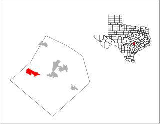
<span class="mw-page-title-main">Chamberlayne, Virginia</span> Census-designated place in Virginia

Chamberlayne is a census-designated place (CDP) in Henrico County, Virginia, United States. The population was 5,581 at the 2020 census.

<span class="mw-page-title-main">Dumbarton, Virginia</span> Census-designated place in Virginia

Dumbarton is a census-designated place (CDP) in Henrico County, Virginia, United States. The population was 7,879 at the 2010 census.

<span class="mw-page-title-main">East Highland Park, Virginia</span> Census-designated place in Virginia

East Highland Park is a census-designated place (CDP) in Henrico County, Virginia, in the United States. The population was 15,131 at the 2020 census.

Highland Springs is a census-designated place (CDP) located in Henrico County, Virginia, United States, 4.3 miles (7 km) east of Richmond. The population was 16,604 at the 2020 census.

<span class="mw-page-title-main">Lakeside, Virginia</span> Census-designated area in Virginia

Lakeside is a census-designated place (CDP) in Henrico County, Virginia, United States. It is an inner suburb of Richmond, Virginia. The population was 12,203 at the 2020 census.

<span class="mw-page-title-main">Laurel, Virginia</span> Census-designated place in Virginia, United States

Laurel is a census-designated place (CDP) in western Henrico County, Virginia. The population was 16,713 at the 2010 United States Census. It is the county seat of Henrico County.

<span class="mw-page-title-main">Montrose, Virginia</span> Census-designated place in Virginia

Montrose is a census-designated place (CDP) in Henrico County, Virginia, United States. The population was 7,909 at the 2020 census.

Short Pump is a census-designated place (CDP) in Henrico County, Virginia, United States. It is a suburb of Richmond, Virginia. The population was 30,626 at the 2020 census.

Wyndham is a census-designated place (CDP) in Henrico County, Virginia, United States, in the West End area outside of Richmond. The population was 9,785 at the 2010 census. The CDP is named for Wyndham, a planned community there. It is an affluent suburb of Richmond, Virginia.

<span class="mw-page-title-main">Laurel Park, Virginia</span> CDP in Virginia, United States

Laurel Park is a census-designated place (CDP) in Henry County, Virginia, United States. The population was 675 at the 2010 census. It is part of the Martinsville Micropolitan Statistical Area.

<span class="mw-page-title-main">Rushmere, Virginia</span> Census-designated place in Virginia, United States

Rushmere is a census-designated place (CDP) in Isle of Wight County, Virginia, United States. The population was 1,018 at the 2010 census.

<span class="mw-page-title-main">Pinch, West Virginia</span> Census-designated place in West Virginia, United States

Pinch is a census-designated place (CDP) in Kanawha County, West Virginia, United States. The population was 3,262 at the 2010 census.

<span class="mw-page-title-main">Mount Gay-Shamrock, West Virginia</span> Census-designated place in West Virginia, United States

Mount Gay-Shamrock is a census-designated place (CDP) in Logan County, West Virginia, United States.

<span class="mw-page-title-main">Switzer, West Virginia</span> Census-designated place in West Virginia, United States

Switzer is an unincorporated community and census-designated place (CDP) in Logan County, West Virginia, United States. The CDP includes the neighboring unincorporated community of Micco. The total CDP population was 595 at the 2010 census.

<span class="mw-page-title-main">Beaver, West Virginia</span> Census-designated place in West Virginia, United States

Beaver is a census-designated place (C.D.P.) in Raleigh County, West Virginia, United States. The population was 1,308 at the 2010 census.

<span class="mw-page-title-main">Piney View, West Virginia</span> Census-designated place in West Virginia, United States

Piney View is a census-designated place (CDP) in Raleigh County, West Virginia, United States. The population was 989 at the 2010 census.

<span class="mw-page-title-main">Stanaford, West Virginia</span> Census-designated place in West Virginia, United States

Stanaford is a census-designated place (CDP) and coal town in Raleigh County, West Virginia, United States. The population was 1,350 at the 2010 census.

<span class="mw-page-title-main">Eastchester (CDP), New York</span> CDP in New York, United States

Eastchester is a census-designated place (CDP) in Westchester County, New York, United States. The population was 19,554 at the 2010 census. The Eastchester CDP consists of the Town of Eastchester excluding the villages of Bronxville and Tuckahoe.

References

  1. 1 2 "U.S. Census website". United States Census Bureau . Retrieved January 31, 2008.
  2. "US Board on Geographic Names". United States Geological Survey. October 25, 2007. Retrieved January 31, 2008.
  3. 1 2 "Profile of General Population and Housing Characteristics: 2010 Demographic Profile Data (DP-1): Tuckahoe CDP, Virginia". United States Census Bureau . Retrieved August 6, 2012.
  4. "Geographic Identifiers: 2010 Demographic Profile Data (G001): Tuckahoe CDP, Virginia". United States Census Bureau . Retrieved August 6, 2012.
  5. Tuckahoe Creek Navigation Company, 1973 Report on canal usage of Tuckahoe Creek from 1827 to 1840.
  6. "Climatological Information for Tuckahoe, Virginia", USA.com, 2003. Web: .
  7. "CENSUS OF POPULATION AND HOUSING (1790-2000)". U.S. Census Bureau . Retrieved July 17, 2010.
  8. U.S. Census Bureau (2014-2018). People Reporting Ancestry American Community Survey 5-year estimates. Retrieved from <https://censusreporter.org>
  9. U.S. Census Bureau (2014-2018). Asian Alone by Selected Groups American Community Survey 5-year estimates. Retrieved from <https://censusreporter.org>
  10. U.S. Census Bureau (2014-2018). Hispanic or Latino Origin by Specific Origin American Community Survey 5-year estimates. Retrieved from <https://censusreporter.org>