Chamberlayne, Virginia

Last updated
Chamberlayne, Virginia
VAMap-doton-Chamberlayne.PNG
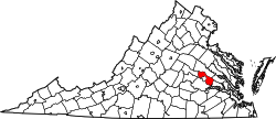
Location of Chamberlayne, Virginia
Coordinates: 37°37′51″N77°26′16″W / 37.63083°N 77.43778°W / 37.63083; -77.43778 Coordinates: 37°37′51″N77°26′16″W / 37.63083°N 77.43778°W / 37.63083; -77.43778
CountryFlag of the United States.svg  United States
State Flag of Virginia.svg  Virginia
County Flag of Henrico County, Virginia.png Henrico
Area
  Total3.7 sq mi (9.5 km2)
  Land3.4 sq mi (8.7 km2)
  Water0.3 sq mi (0.9 km2)
Elevation
[1]
180 ft (50 m)
Population
 (2020)
  Total5,581
  Density1,500/sq mi (590/km2)
Time zone UTC−5 (Eastern (EST))
  Summer (DST) UTC−4 (EDT)
FIPS code 51-14544 [2]
GNIS feature ID2389300 [1]

Chamberlayne is a census-designated place (CDP) in Henrico County, Virginia, United States. The population was 5,581 at the 2020 census. [3]

Contents

Geography

Chamberlayne is located at 37°37′51″N77°26′16″W / 37.63083°N 77.43778°W / 37.63083; -77.43778 (37.630794, 77.437807). [4]

According to the United States Census Bureau, the CDP has a total area of 3.7 square miles (9.5 km2), of which 3.4 square miles (8.7 km2) is land and 0.35 square miles (0.9 km2), or 8.99%, is water. [5]

Demographics

Historical population
CensusPop.Note
1980 5,136
1990 4,577−10.9%
2000 4,380−4.3%
2010 5,45624.6%
2020 5,5812.3%
U.S. Decennial Census [6]
2010 [7] 2020 [8]

2020 census

Chamberlayne CDP, Virginia - Demographic Profile
(NH = Non-Hispanic)
Note: the US Census treats Hispanic/Latino as an ethnic category. This table excludes Latinos from the racial categories and assigns them to a separate category. Hispanics/Latinos may be of any race.
Race / EthnicityPop 2010 [7] Pop 2020 [8] % 2010% 2020
White alone (NH)1,8361,81733.65%32.56%
Black or African American alone (NH)3,1703,05558.10%54.74%
Native American or Alaska Native alone (NH)7170.13%0.30%
Asian alone (NH)1541682.82%3.01%
Pacific Islander alone (NH)000.00%0.00%
Some Other Race alone (NH)10220.18%0.39%
Mixed Race/Multi-Racial (NH)1192432.18%4.35%
Hispanic or Latino (any race)1602592.93%4.64%
Total5,4565,581100.00%100.00%

2000 Census

As of the census [2] of 2000, there were 4,380 people, 1,884 households, and 1,352 families residing in the CDP. The population density was 1,163.5 people per square mile (449.8/km2). There were 1,916 housing units at an average density of 509.0/sq mi (196.7/km2). The racial makeup of the CDP was 47.83% White, 49.20% African American, 0.16% Native American, 1.12% Asian, 0.09% Pacific Islander, 0.39% from other races, and 1.21% from two or more races. Hispanic or Latino of any race were 0.84% of the population.

There were 1,884 households, out of which 19.5% had children under the age of 18 living with them, 58.4% were married couples living together, 10.0% had a female householder with no husband present, and 28.2% were non-families. 24.2% of all households were made up of individuals, and 12.1% had someone living alone who was 65 years of age or older. The average household size was 2.32 and the average family size was 2.73.

In the CDP, the population was spread out, with 16.6% under the age of 18, 4.5% from 18 to 24, 22.2% from 25 to 44, 32.4% from 45 to 64, and 24.2% who were 65 years of age or older. The median age was 49 years. For every 100 females there were 89.0 males. For every 100 females age 18 and over, there were 86.2 males.

The median income for a household in the CDP was $54,022, and the median income for a family was $60,425. Males had a median income of $40,858 versus $32,422 for females. The per capita income for the CDP was $28,405. About 1.9% of families and 3.3% of the population were below the poverty line, including 2.7% of those under age 18 and 2.3% of those age 65 or over.

Related Research Articles

<span class="mw-page-title-main">Green Valley, Maryland</span> Census-designated place in Maryland

Green Valley is an unincorporated area and census-designated place (CDP) in southern Frederick County, Maryland, United States. The population was 12,643 at the 2020 census. The area was listed as a census-designated place in 2000 but not listed as part of any CDP at the 2010 census. It was re-designated a census-designated place for the 2020 census.

<span class="mw-page-title-main">Brimhall Nizhoni, New Mexico</span> Census-designated place in McKinley County, New Mexico, United States

Brimhall Nizhoni is a census-designated place (CDP) in McKinley County, New Mexico, United States. The population was 199 at the 2010 census. The Navajo Coyote Canyon Chapter House is located in Brimhall.

<span class="mw-page-title-main">Bridgetown North, Ohio</span> Former CDP in Ohio, United States

Bridgetown North was a census-designated place (CDP) in Hamilton County, Ohio, United States. The population was 12,569 at the 2000 census. Its name was changed to Bridgetown for the 2010 census, as its area expanded to the south.

<span class="mw-page-title-main">Guys Mills, Pennsylvania</span> Census-designated place in Pennsylvania, United States

Guys Mills is a census-designated place in Crawford County, Pennsylvania, United States. The population was 124 at the 2010 census.

<span class="mw-page-title-main">Dooms, Virginia</span> CDP in Virginia, United States

Dooms is a census-designated place (CDP) in Augusta County, Virginia, United States. The population was 1,327 at the 2010 census. It is part of the Staunton–Waynesboro Micropolitan Statistical Area.

<span class="mw-page-title-main">Bensley, Virginia</span> CDP in Virginia, United States

Bensley is a census-designated place (CDP) in Chesterfield County, Virginia, United States. It is an inner suburb of Richmond, Virginia. The population was 5,819 at the 2010 census. Bensley Community building is inside of Bensley park. The community building is outside of Bensley, setting in walking distance of the CDP. The community is an old village with no active government. The community is over 100 years old. A new police substation in the village is next to the old Bensley Bermuda Rescue Squad, near DuPont Spruance.

<span class="mw-page-title-main">Chester, Virginia</span> CDP in Virginia, United States

Chester is a census-designated place (CDP) in Chesterfield County, Virginia, United States. Per the 2020 census, the population was 23,414.

<span class="mw-page-title-main">Chesterfield, Virginia</span> Unincorporated community in Virginia, United States

Chesterfield is an unincorporated community that is the county seat of Chesterfield County, Virginia, United States. It was a census-designated place (CDP) at the 2020 census. It was not delineated as a CDP for the 2010 census. The Chesterfield County Courthouse and Courthouse Square are listed in the National Register of Historic Places. The area is also home of the Chesterfield County Government Complex.

<span class="mw-page-title-main">Ettrick, Virginia</span> CDP in Virginia, United States

Ettrick is a census-designated place (CDP) in Chesterfield County, Virginia, United States. Per the 2020 census, the population was 7,241. The town is home to Virginia State University and the Petersburg Amtrak train station.

<span class="mw-page-title-main">Dumbarton, Virginia</span> Census-designated place in Virginia

Dumbarton is a census-designated place (CDP) in Henrico County, Virginia, United States. The population was 7,879 at the 2010 census.

<span class="mw-page-title-main">East Highland Park, Virginia</span> Census-designated place in Virginia

East Highland Park is a census-designated place (CDP) in Henrico County, Virginia, in the United States. The population was 15,131 at the 2020 census.

Highland Springs is a census-designated place (CDP) located in Henrico County, Virginia, United States, 4.3 miles (7 km) East of Richmond. The population was 16,604 at the 2020 census.

<span class="mw-page-title-main">Lakeside, Virginia</span> Census-designated area in Virginia

Lakeside is a census-designated place (CDP) in Henrico County, Virginia, United States. It is an inner suburb of Richmond, Virginia. The population was 11,849 at the 2010 census.

<span class="mw-page-title-main">Montrose, Virginia</span> Census-designated place in Virginia

Montrose is a census-designated place (CDP) in Henrico County, Virginia, United States. The population was 7,909 at the 2020 census.

Wyndham is a census-designated place (CDP) in Henrico County, Virginia, United States, in the West End area outside of Richmond. The population was 9,785 at the 2010 census. The CDP is named for Wyndham, a planned community there. It is an affluent suburb of Richmond, Virginia.

<span class="mw-page-title-main">Yorkshire, Virginia</span> CDP in Virginia, United States

Yorkshire is a census-designated place (CDP) in Prince William County, Virginia, United States. It is an annex of Manassas, Virginia. The population was 6,732 at the 2000 census.

<span class="mw-page-title-main">West Wenatchee, Washington</span> Unincorporated community in Washington, United States

West Wenatchee is a former census-designated place (CDP) and now an unincorporated community in Chelan County, Washington, United States. The United States Census Bureau removed the community at the 2010 census, with most of its former area being merged into Wenatchee city limits, raising the population significantly. The area that was West Wenatchee is part of the Wenatchee–East Wenatchee Metropolitan Statistical Area.

<span class="mw-page-title-main">Marblemount, Washington</span> CDP in Washington, United States

Marblemount is a census-designated place in Skagit County, Washington, United States. The population was 203 at the 2010 census. It is included in the Mount Vernon–Anacortes, Washington Metropolitan Statistical Area.

<span class="mw-page-title-main">Elkview, West Virginia</span> Census-designated place in West Virginia, United States

Elkview is a census-designated place (CDP) in Kanawha County, West Virginia, United States. The population was 1,222 at the 2010 census. It is named after the Elk River, which flows into the Kanawha River.

Vista West is a census-designated place (CDP) in Natrona County, Wyoming, United States. It is part of the Casper, Wyoming Metropolitan Statistical Area. The population was 951 at the 2010 census.

References

  1. 1 2 "Chamberlayne Census Designated Place". Geographic Names Information System . United States Geological Survey, United States Department of the Interior.
  2. 1 2 "U.S. Census website". United States Census Bureau . Retrieved 2008-01-31.
  3. "Chamberlayne CDP, Virginia". United States Census Bureau . Retrieved January 30, 2022.
  4. "US Gazetteer files: 2010, 2000, and 1990". United States Census Bureau. 2011-02-12. Retrieved 2011-04-23.
  5. "Geographic Identifiers: 2010 Demographic Profile Data (G001): Chamberlayne CDP, Virginia". United States Census Bureau . Retrieved August 6, 2012.
  6. "Decennial Census of Population and Housing by Decades". US Census Bureau.
  7. 1 2 "P2 HISPANIC OR LATINO, AND NOT HISPANIC OR LATINO BY RACE - 2010: DEC Redistricting Data (PL 94-171) - Chamberlayne CDP, Virginia". United States Census Bureau .
  8. 1 2 "P2 HISPANIC OR LATINO, AND NOT HISPANIC OR LATINO BY RACE - 2020: DEC Redistricting Data (PL 94-171) - Chamberlayne CDP, Virginia". United States Census Bureau .