
Minas Gerais is a state in Southeastern Brazil. It ranks as the second most populous, the third by gross domestic product (GDP), and the fourth largest by area in the country. The state's capital and largest city, Belo Horizonte, is a major urban and finance center in Latin America, and the sixth largest municipality in Brazil, after the cities of São Paulo, Rio de Janeiro, Salvador, Brasília and Fortaleza, but its metropolitan area is the third largest in Brazil with just over 5,800,000 inhabitants, after those of São Paulo and Rio de Janeiro. Nine Brazilian presidents were born in Minas Gerais, the most of any state. The state has 10.1% of the Brazilian population and is responsible for 8.7% of the Brazilian GDP.

The São Francisco River or Rio São Francisco is a river in Brazil. With a length of 2,914 kilometres (1,811 mi), it is the longest river that runs entirely in Brazilian territory, and the fourth longest in South America and overall in Brazil. It used to be known as the Opara by the indigenous people before colonisation, and is today also known as Velho Chico.

Manhuaçu is a municipality in Eastern Minas Gerais state, in Brazil. Its population was 91,169 (2020) and its area is 628 km².

Uberlândia is a municipality in the state of Minas Gerais, southeastern Brazil. It is the second largest municipality in the state of Minas Gerais after the state capital Belo Horizonte. Its population in 2020 was 699,097, making it the fourth largest city of the interior region of Brazil. The city is located on the Brazilian Highlands 2,802 feet (854 m) above sea level. It is an important logistic hub between São Paulo and Brasília. The city sits within the Brazilian cerrado and has eight protected zones of tropical savanna vegetation.

Pirapora is a municipality in northcentral Minas Gerais in Brazil. The population is 56,640 in an area of 550 km². The name Pirapora comes from the Tupi words for "fish" + "jump", referring to the piracema season when a mass migration of fishes ascends the São Francisco River to spawn.
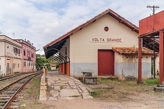
Volta Grande is a Brazilian municipality in the state of Minas Gerais. As of 2020 its population was estimated to be 5,261.

Almenara, is a municipality in the northeast of the Brazilian state of Minas Gerais. Situated on the Jequitinhonha River it is the largest city in that river valley. Its 2020 population was estimated at 42,143 and the municipal area was 2,301 km².

The Paranaíba River is a Brazilian river whose source lies in the state of Minas Gerais in the Mata da Corda mountains, municipality of Rio Paranaíba, at an altitude of 1,148 meters; on the other face of this mountain chain are the sources of the Abaeté river, tributary of the São Francisco River. The length of the river is approximately 1,000 kilometres (620 mi) up to the junction with the Grande River, both of which then form the Paraná River, at the point that marks the borders of the states of São Paulo, Minas Gerais, and Mato Grosso do Sul.

Santa Bárbara is a Brazilian municipality founded in 1704 and located in the state of Minas Gerais.

The Maxakalían languages were first classified into the Jê languages. It was only in 1931 that Loukotka separated them from the Jê family. Alfred Métraux and Curt Nimuendaju Unkel considered the Maxakalían family isolated from others. John Alden Mason suggests a connection with the Macro-Jê stock, confirmed by Aryon Dall’Igna Rodrigues.

The Mantiqueira Mountains are a mountain range in Southeastern Brazil, with parts in the states of São Paulo, Minas Gerais and Rio de Janeiro. It rises abruptly from the northwestern bank of the Paraíba do Sul River and extends northeastward for approximately 320 km (200 mi), reaching a height of 2,798 m (9,180 ft) at Pedra da Mina. The mountains, which eventually merge with the Serra do Espinhaço, were originally forest-covered, except for the peaks that rise above the tree line. They provide charcoal and pasture for cattle; on the lower slopes there are several health and tourist resorts, such as Campos do Jordão, Brazil's highest city. The name Mantiqueira derives from a Tupi word meaning "mountains that cry", denoting the large number of springs and streams found there.

Unaí is a municipality in the Northern Region of Minas Gerais, in the Brazilian state of Minas Gerais, in the Southeast Region of Brazil. It is located 590 km from the capital of Minas Gerais and 164 km from the federal capital. Unaí is the main municipality of its micro-region of the same name and, together with Paracatu, the most important city of the said mesoregion of Minas Gerais. Due to its geopolitical location, because it is geographically and politically linked to Brasilia and politically to Belo Horizonte, the municipality has a strong economic dynamism for a municipality that still carries the typically mineiro custom.

Córrego Danta is a town located in the state of Minas Gerais, Brazil.

Purian is a pair of extinct languages of eastern Brazil:
Pará de Minas is a Brazilian municipality located in the state of Minas Gerais.

Cônego Marinho is a municipality in the north of the state of Minas Gerais in Brazil. As of 2020 the population was 7,686 in an area of 1,618 km².

Jequitaí is a Brazilian municipality located in the north of the state of Minas Gerais. In 2020 the population was 7,468 in a total area of 1,268 km². It became a municipality in 1948.
São Romão is a Brazilian municipality located in the north of the state of Minas Gerais. In 2020 the population was 12,529 in a total area of 2,432 km². It became a municipality in 1943.

Senador Modestino Gonçalves is a Brazilian municipality in the state of Minas Gerais.

Nanuque is a municipality in the state of Minas Gerais, in the southeastern region of Brazil, belonging to Mucuri Valley and Region Nanuque. The relief consists of inselbergs and seas of hills, and the Serra dos Aimorés as predominant characteristic. Considered the 79th most populous city in the state, the 2nd Northeast 1st miner and its region, with 40,665 inhabitants according to the 2020 estimate. According to DENATRAN its fleet is 17,782 motor vehicles. As a regional hub ten municipalities, their total area 116,545 inhabitants and a total area of 8471.872 km ². Nanuque, cut the highway Ox (BR-418), reference is to be en route to the northern coast of Espirito Santo state by state highway LMG-719 and the southern coast of Bahia state by the then federal highway BR-418, of which is 605 km to the northeast of the state capital Belo Horizonte and 1257 km east of the federal capital Brasília.
