
The Rio Grande, known in Mexico as the Río Bravo del Norte or simply the Río Bravo, is one of the principal rivers in the southwestern United States and in northern Mexico. The length of the Rio Grande is 1,896 miles (3,051 km), making it the 4th longest river in North America by main stem. It originates in south-central Colorado, in the United States, and flows to the Gulf of Mexico. The Rio Grande drainage basin (watershed) has an area of 182,200 square miles (472,000 km2); however, the endorheic basins that are adjacent to and within the greater drainage basin of the Rio Grande increase the total drainage-basin area to 336,000 square miles (870,000 km2).

The Río de la Plata, also called the River Plate or La Plata River in English, is the estuary formed by the confluence of the Uruguay River and the Paraná River at Punta Gorda. It empties into the Atlantic Ocean and forms a funnel-shaped indentation on the southeastern coastline of South America. Depending on the geographer, the Río de la Plata may be considered a river, an estuary, a gulf, or a marginal sea. If considered a river, it is the widest in the world, with a maximum width of 220 kilometres (140 mi).
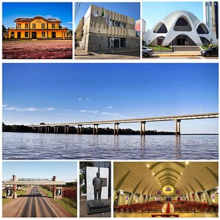
São Borja is a city in the Brazilian state of Rio Grande do Sul. São Borja is the oldest municipality in the Brazilian state of Rio Grande do Sul and was founded in 1682 by the Jesuits as the first of the Seven Points of the Missions, and named São Francisco de Borja, in honor of Saint Francis Borgia.

The Río Tinto is a river in southwestern Spain that rises in the Sierra Morena mountains of Andalusia. It flows generally south-southwest, reaching the Gulf of Cádiz at Huelva. The Rio Tinto river has a unique red and orange colour derived from its chemical makeup that is extremely acidic and with very high levels of iron and heavy metals.

The Rio Grande Wild and Scenic River is a U.S. National Wild and Scenic River that protects 260 miles (420 km) of the Rio Grande in New Mexico and Texas. The designation was first applied in 1968 to a 55.7-mile (89.6 km) stretch of the river in New Mexico; an additional 191.2 miles (307.7 km) of the river in Texas was added in 1978, followed by another 12.5 miles (20.1 km) in New Mexico in 1994.

The Valdivia River or Río Valdivia, as it is known locally, is a major river in southern Chile. It is the continuation of the Calle-Calle River, from the point where it meets the Cau-Cau River in the city of Valdivia. The Valdivia river ends in Corral Bay, on the Pacific coast. Other tributaries are the Cruces River, the Tornagaleones River and the Futa River. Pedro de Valdivia Bridge crosses the river in downtown Valdivia.

Purian is a pair of extinct languages of eastern Brazil:

Bueno River is a river in southern Chile. It originates in Ranco Lake and like most of Chile rivers it drains into the Pacific Ocean at the southern boundary of the Valdivian Coastal Reserve. Its lower flow forms the border between Osorno Province and Ranco Province. Traditionally it marks also the northern boundary of the indigenous Huilliche territory known as Futahuillimapu. The river passes through Río Bueno commune and city that takes name from the river.

Caraá is a municipality in the state of Rio Grande do Sul, Brazil where Rio dos Sinos' river rises. It was originally part of the city Santo Antônio da Patrulha, emancipated on December 28, 1995.
Mariano Moro is a municipality in the state of Rio Grande do Sul, Brazil.

Muçum is a small town in the state of Rio Grande do Sul, Brazil.

São Jerônimo is a municipality in the state of Rio Grande do Sul, Brazil.

Dos Rios is an unincorporated community in Mendocino County, California. It is located 7 miles (11 km) east-northeast of Laytonville, at an elevation of 961 feet (293 m). Dos Rios's ZIP code, 95429, has a population of 70. The Dos Rios AVA is located in the area.

Vaupés River is a tributary of the Rio Negro in South America. It rises in the Guaviare Department of Colombia, flowing east through Guaviare and Vaupés Departments. It forms part of the international border between the Vaupés department of Colombia and the Amazonas state of Brazil. On the border it merges with the Papurí River and becomes known as the Uaupés. In 1847 an explorer saw a rapid which hurled its waves 12 or 15 metres in the air, "as if great subaqueous explosions were taking place." The river continues on east through the Alto Rio Negro Indigenous Territory until it flows into the Rio Negro at São Joaquim, Amazonas. Vaupés is a blackwater river.
The Palena River or Carrenleufú is a river shared by Chile and Argentina in Northern Patagonia. It drains the waters of the Vintter Lake, also shared by these nations, and it flows into the Pacific Ocean. 56.5% of the river basin lies in Chile.
José Luis Vásquez is a retired Peruvian professional football player and manager.
Hot springs, Pachia is a hot spring in Tacna, Peru. It's located 22.8 km away from Tacna to the east, placed on the shores of the Caplina River, and 1,400m above sea level.

Casiri, also known as Paucarani, is an about 5,650 metres (18,537 ft) high complex volcano in the Barroso mountain range of the Andes, in the Tacna Region of Peru. It consists of four individual volcanic edifices with lava domes; the southeasternmost edifice has been active during the Holocene, producing thick lava flows that have overrun moraines of Pleistocene age. The youngest lava flow has been dated to 2,600 ± 400 years ago. Although no historical eruptions are known, the volcano is considered to be potentially active and is monitored.

