
Bahia is one of the 26 states of Brazil, located in the Northeast Region of the country. It is the fourth-largest Brazilian state by population and the 5th-largest by area. Bahia's capital is the city of Salvador, on a spit of land separating the Bay of All Saints from the Atlantic. Once a stronghold of supporters of direct rule of Brazil by the Portuguese monarchy, and dominated by agricultural, slaving, and ranching interests, Bahia is now a predominantly working-class industrial and agricultural state. The state is home to 7% of the Brazilian population and produces 4.2% of the country's GDP.

The caravel is a small sailing ship that uses both lateen and square sails and was known for its agility and speed and its capacity for sailing windward (beating). Caravels were used by the Portuguese and Spanish for the voyages of exploration during the 15th and 16th centuries, in the Age of Discovery.

Abaeté Linhas Aéreas was a domestic regional airline headquartered in Lauro de Freitas, near Salvador da Bahia, Brazil. Founded in 1994, it ceased operations in 2012 and in 2018 had its license revoked by the National Civil Aviation Agency of Brazil (ANAC). The airline was a subsidiary of Aerotáxi Abaeté, which in 2020 resumed regular commercial flights.

The Maxakalían languages are a group of related indigenous languages of Brazil, named after Maxakalí, the one surviving language in the group. Many of the other, extinct, languages are poorly attested and linguists differ in the languages they identify as part of the group. The Maxakalían group is today usually considered part of the Macro-Jê language family.

Caravelas is a city of about 20,000 inhabitants in southern Bahia, Brazil, a few miles above the mouth of the Caravelas River.

The Archdiocese of São Salvador da Bahia is part of the Roman Catholic Church in Brazil. The Archbishop of São Salvador da Bahia also carries the title Primate of Brazil. The archdiocese is located in the city of Salvador, Bahia.

Araçuaí is a Brazilian municipality located in the northeast of the state of Minas Gerais in the Jequitinhonha River valley. The Araçuaí River, a tributary of the Jequitinhonha, flows through it. Its population as of 2020 was estimated to be 36,712 people living in a total area of 2,235 km2. The city belongs to the mesoregion of Jequitinhonha and the microregion of Araçuaí. The city is the seat of the Roman Catholic Diocese of Araçuaí. The elevation of the municipal seat is 307 meters. It became a municipality in 1870.
Itaobim is a municipality in the northeast of the Brazilian state of Minas Gerais. Its population in 2020 was 21,029 inhabitants in a total area of 680 km². It belongs to the Pedra Azul statistical microregion. The elevation of the municipal seat is 180 meters. It became a municipality in 1962. Neighboring municipalities are Medina, Jequitinhonha, Ponto dos Volantes and Itinga. The distance to the state capital, Belo Horizonte is 604 kilometers.

The Roman Catholic Diocese of Teixeira de Freitas–Caravelas is a diocese located in the cities of Teixeira de Freitas and Caravelas in the ecclesiastical province of São Salvador da Bahia in Brazil.
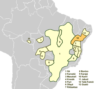
The Karirí languages, generally considered dialects of a single language, were a group of languages formerly spoken by the Kiriri people of Brazil. It was spoken until the middle of the 20th century; the 4,000 ethnic Kiriri are now monolingual Portuguese speakers, though a few know common phrases and names of medicinal plants.

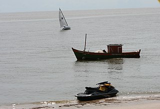
The Itanhém River is a river of Bahia state in eastern Brazil. The Itanhém River, also called the Alcobaça River, cuts through the Bahia municipalities of Alcobaça and Itanhém, and flows into Barra do Itanhém Beach in Alcobaça. It is born from the Machacalis in the municipality of Fronteira dos Vales, state of Minas Gerais, and runs from west to east to the mouth of Alcobaça in Bahia, where it flows into the Atlantic Ocean. This river used to be the main access of the white colonizers originating from the Vila de Caravelas to the sertão baiano. The most common fish found in the river Itanhém are: cordata, traíra, piaú, catfish and cascudo. But there are some crustaceans like pitu and shrimp.

Jaguaripe is a municipality in the state of Bahia in the North-East region of Brazil. It covers 863.424 km2 (333.370 sq mi), and has a population of 18,981 with a population density of 18.32 inhabitants per square kilometer. Jaguaripe is located 130 km (81 mi) from the state capital of Bahia, Salvador. Jaguaripe shares a border with the municipalities of Aratuípe, Nazaré, Maragogipe, Laje, São Miguel das Matas, and Santo Antônio de Jesus. It was the first municipality created outside of Salvador, dating to 1693.
Nova Viçosa is a municipality in the state of Bahia in the North-East region of Brazil. It was "discovered" in 1720 and became a municipality in 1962. The municipality contains part of the Cassurubá Extractive Reserve, a 100,768 hectares sustainable use conservation unit that protects an area of mangroves, river and sea where shellfish are harvested.

The square-rigged caravel, was a sailing ship created by the Portuguese in the second half of the fifteenth century. A much larger version of the caravel, its use was most notorious beginning in the end of that century. The square-rigged caravel held a notable role in the Portuguese expansion during the Age of Discovery, especially in the first half of the sixteenth century, for its exceptional maneuverability and combat capabilities. This ship was also sometimes adopted by other European powers. Its hull resembled the shape of the later galleon and some scholars have claimed that this vessel is a forerunner of the fighting galleon, by the name of caravela de armada.
The Cassurubá Extractive Reserve is an extractive reserve in the state of Bahia, Brazil.
Caravelas Airport is the airport serving Caravelas, Brazil.

Clementino Rodrigues was a Brazilian samba composer and singer.

Aerotáxi Abaeté (ATA), known as Abaeté Aviação, is a domestic subregional airline and air taxi headquartered in Salvador da Bahia, Brazil. Although the company was established in 1979, it was not authorized to operate regular flights until 2020.
Makoní is an extinct Maxakalian language of Brazil.
