Related Research Articles

Efforts to scientifically ascertain and attribute mechanisms responsible for recent global warming and related climate changes on Earth have found that the main driver is elevated levels of greenhouse gases produced by human activities, with natural forces adding variability. The likely range of human-induced surface-level air warming by 2010–2019 compared to levels in 1850–1900 is 0.8 °C to 1.3 °C, with a best estimate of 1.07 °C. This is close to the observed overall warming during that time of 0.9 °C to 1.2 °C, while temperature changes during that time were likely only ±0.1 °C due to natural forcings and ±0.2 °C due to variability in the climate.

Satellite temperature measurements are inferences of the temperature of the atmosphere at various altitudes as well as sea and land surface temperatures obtained from radiometric measurements by satellites. These measurements can be used to locate weather fronts, monitor the El Niño-Southern Oscillation, determine the strength of tropical cyclones, study urban heat islands and monitor the global climate. Wildfires, volcanos, and industrial hot spots can also be found via thermal imaging from weather satellites.

The instrumental temperature record is a record of temperatures within Earth's climate based on direct, instrument-based measurements of air temperature and ocean temperature. Instrumental temperature records are distinguished from indirect reconstructions using climate proxy data such as from tree rings and ocean sediments. Instrument-based data are collected from thousands of meteorological stations, buoys and ships around the globe. Whilst many heavily-populated areas have a high density of measurements, observations are more widely spread in sparsely populated areas such as polar regions and deserts, as well as over many parts of Africa and South America. Measurements were historically made using mercury or alcohol thermometers which were read manually, but are increasingly made using electronic sensors which transmit data automatically. Records of global average surface temperature are usually presented as anomalies rather than as absolute temperatures. A temperature anomaly is measured against a reference value. For example, a commonly used baseline period is the time period 1951-1980.

The first systematic measurements of global direct irradiance at the Earth's surface began in the 1950s. A decline in irradiance was soon observed, and it was given the name of global dimming. It continued from 1950s until 1980s, with an observed reduction of 4–5% per decade, even though solar activity did not vary more than the usual at the time. Global dimming has instead been attributed to an increase in atmospheric particulate matter, predominantly sulfate aerosols, as the result of rapidly growing air pollution due to post-war industrialization. After 1980s, global dimming started to reverse, alongside reductions in particulate emissions, in what has been described as global brightening, although this reversal is only considered "partial" for now. The reversal has also been globally uneven, as the dimming trend continued during the 1990s over some mostly developing countries like India, Zimbabwe, Chile and Venezuela. Over China, the dimming trend continued at a slower rate after 1990, and did not begin to reverse until around 2005.

Radiative forcing is the change in energy flux in the atmosphere caused by natural or anthropogenic factors of climate change as measured by watts / meter². It is a scientific concept used to quantify and compare the external drivers of change to Earth's energy balance. System feedbacks and internal variability are related concepts, encompassing other factors that also influence the direction and magnitude of imbalance.
John Raymond Christy is a climate scientist at the University of Alabama in Huntsville (UAH) whose chief interests are satellite remote sensing of global climate and global climate change. He is best known, jointly with Roy Spencer, for the first successful development of a satellite temperature record.

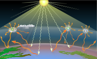
Earth's energy budget accounts for the balance between the energy that Earth receives from the Sun and the energy the Earth loses back into outer space. Smaller energy sources, such as Earth's internal heat, are taken into consideration, but make a tiny contribution compared to solar energy. The energy budget also accounts for how energy moves through the climate system. Because the Sun heats the equatorial tropics more than the polar regions, received solar irradiance is unevenly distributed. As the energy seeks equilibrium across the planet, it drives interactions in Earth's climate system, i.e., Earth's water, ice, atmosphere, rocky crust, and all living things. The result is Earth's climate.

The global temperature record shows the fluctuations of the temperature of the atmosphere and the oceans through various spans of time. There are numerous estimates of temperatures since the end of the Pleistocene glaciation, particularly during the current Holocene epoch. Some temperature information is available through geologic evidence, going back millions of years. More recently, information from ice cores covers the period from 800,000 years before the present time until now. A study of the paleoclimate covers the time period from 12,000 years ago to the present. Tree rings and measurements from ice cores can give evidence about the global temperature from 1,000-2,000 years before the present until now. The most detailed information exists since 1850, when methodical thermometer-based records began.

This is a list of the most influential long-lived, well-mixed greenhouse gases, along with their tropospheric concentrations and direct radiative forcings, as identified by the Intergovernmental Panel on Climate Change (IPCC). Abundances of these trace gases are regularly measured by atmospheric scientists from samples collected throughout the world. Since the 1980s, their forcing contributions are also estimated with high accuracy using IPCC-recommended expressions derived from radiative transfer models.

The advanced microwave sounding unit (AMSU) is a multi-channel microwave radiometer installed on meteorological satellites. The instrument examines several bands of microwave radiation from the atmosphere to perform atmospheric sounding of temperature and moisture levels.

Over the last two centuries many environmental chemical observations have been made from a variety of ground-based, airborne, and orbital platforms and deposited in databases. Many of these databases are publicly available. All of the instruments mentioned in this article give online public access to their data. These observations are critical in developing our understanding of the Earth's atmosphere and issues such as climate change, ozone depletion and air quality. Some of the external links provide repositories of many of these datasets in one place. For example, the Cambridge Atmospheric Chemical Database, is a large database in a uniform ASCII format. Each observation is augmented with the meteorological conditions such as the temperature, potential temperature, geopotential height, and equivalent PV latitude.
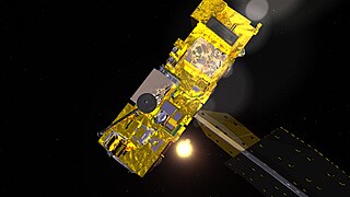
The atmospheric infrared sounder (AIRS) is one of six instruments flying on board NASA's Aqua satellite, launched on May 4, 2002. The instrument is designed to support climate research and improve weather forecasting.
A greenhouse gas (GHG or GhG) is a gas that absorbs and emits radiant energy at thermal infrared wavelengths, causing the greenhouse effect. The primary greenhouse gases in Earth's atmosphere are water vapor (H2O), carbon dioxide (CO2), methane (CH4), nitrous oxide (N2O), and ozone (O3). Without greenhouse gases, the average temperature of Earth's surface would be about −18 °C (0 °F), rather than the present average of 15 °C (59 °F). Greenhouse gases exist in many atmospheres, creating greenhouse effects on Mars, Titan and particularly in the thick atmosphere of Venus.
Remote Sensing Systems (RSS) is a private research company founded in 1974 by Frank Wentz. It processes microwave data from a variety of NASA satellites. Most of their research is supported by the Earth Science Enterprise program. The company is based in Santa Rosa, California.
The microwave sounding unit (MSU) was the predecessor to the Advanced Microwave Sounding Unit (AMSU).
Frank Wentz is the CEO and director of Remote Sensing Systems, a company he founded in 1974, which specializes in satellite microwave remote sensing research. Together with Carl Mears, he is best known for developing a satellite temperature record from MSU and AMSU. Intercomparison of this record with the earlier UAH satellite temperature record, developed by John Christy and Roy Spencer, revealed deficiencies in the earlier work; specifically, the warming trend in the RSS version is larger than the University of Alabama in Huntsville (UAH) one. From 1978 to 1982, Wentz was a member of NASA's SeaSat Experiment Team involved in the development of physically based retrieval methods for microwave scatterometers and radiometers. He has also investigated the effect of climate change on satellite-derived evaporation, precipitation and surface wind values. His findings are different from most climate change model predictions.
Microwave Sounding Unit temperature measurements refers to temperature measurement using the Microwave Sounding Unit instrument and is one of several methods of measuring Earth atmospheric temperature from satellites. Microwave measurements have been obtained from the troposphere since 1979, when they were included within NOAA weather satellites, starting with TIROS-N. By comparison, the usable balloon (radiosonde) record begins in 1958 but has less geographic coverage and is less uniform.
The UAH satellite temperature dataset, developed at the University of Alabama in Huntsville, infers the temperature of various atmospheric layers from satellite measurements of the oxygen radiance in the microwave band, using Microwave Sounding Unit temperature measurements.
The Advanced Technology Microwave Sounder (ATMS) is a 22-channel scanning microwave radiometer for observation of the Earth's atmosphere and surface. It is the successor to the Advanced Microwave Sounding Unit (AMSU) on NOAA weather satellites. ATMS units have been flown on the Suomi NPP and on the Joint Polar Satellite System.
Joyce Penner is an atmospheric scientist known for her research on climate change, especially on the impact of aerosols and clouds.
References
- ↑ "RSS People Carl Mears". Archived from the original on 15 July 2011. Retrieved 12 May 2011.
| | This biographical article about a climatologist or meteorologist is a stub. You can help Wikipedia by expanding it. |