
Satellite temperature measurements are inferences of the temperature of the atmosphere at various altitudes as well as sea and land surface temperatures obtained from radiometric measurements by satellites. These measurements can be used to locate weather fronts, monitor the El Niño-Southern Oscillation, determine the strength of tropical cyclones, study urban heat islands and monitor the global climate. Wildfires, volcanos, and industrial hot spots can also be found via thermal imaging from weather satellites.

Numerical climate models are mathematical models that can simulate the interactions of important drivers of climate. These drivers are the atmosphere, oceans, land surface and ice. Scientists use climate models to study the dynamics of the climate system and to make projections of future climate and of climate change. Climate models can also be qualitative models and contain narratives, largely descriptive, of possible futures.

The atmosphere of Earth is composed of a layer of gas mixture that surrounds the Earth's planetary surface, known collectively as air, with variable quantities of suspended aerosols and particulates, all retained by Earth's gravity. The atmosphere serves as a protective buffer between the Earth's surface and outer space, shields the surface from most meteoroids and ultraviolet solar radiation, keeps it warm and reduces diurnal temperature variation through heat retention, redistributes heat and moisture among different regions via air currents, and provides the chemical and climate conditions allowing life to exist and evolve on Earth.

Global cooling was a conjecture, especially during the 1970s, of imminent cooling of the Earth culminating in a period of extensive glaciation, due to the cooling effects of aerosols or orbital forcing. Some press reports in the 1970s speculated about continued cooling; these did not accurately reflect the scientific literature of the time, which was generally more concerned with warming from an enhanced greenhouse effect.
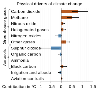
Radiative forcing is a concept used to quantify a change to the balance of energy flowing through a planetary atmosphere. Various factors contribute to this change in energy balance, such as concentrations of greenhouse gases and aerosols, and changes in surface albedo and solar irradiance. In more technical terms, it is defined as "the change in the net, downward minus upward, radiative flux due to a change in an external driver of climate change." These external drivers are distinguished from feedbacks and variability that are internal to the climate system, and that further influence the direction and magnitude of imbalance. Radiative forcing on Earth is meaningfully evaluated at the tropopause and at the top of the stratosphere. It is quantified in units of watts per square meter, and often summarized as an average over the total surface area of the globe.
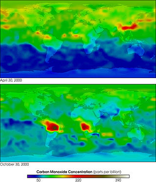
MOPITT is an ongoing astronomical instrument aboard NASA's Terra satellite that measures global tropospheric carbon monoxide levels. It is part of NASA's Earth Observing System (EOS), and combined with the other payload remote sensors on the Terra satellite, the spacecraft monitors the Earth's environment and climate changes. Following its construction in Canada, MOPITT was launched into Earth's orbit in 1999 and utilizes gas correlation spectroscopy to measure the presence of different gases in the troposphere. The fundamental operations occur in its optical system composed of two optical tables holding the bulk of the apparatus. Results from the MOPITT enable scientists to better understand carbon monoxide's effects on a global scale, and various studies have been conducted based on MOPITT's measurements.
John Raymond Christy is a climate scientist at the University of Alabama in Huntsville (UAH) whose chief interests are satellite remote sensing of global climate and global climate change. He is best known, jointly with Roy Spencer, for the first successful development of a satellite temperature record.

James Edward Hansen is an American adjunct professor directing the Program on Climate Science, Awareness and Solutions of the Earth Institute at Columbia University. He is best known for his research in climatology, his 1988 Congressional testimony on climate change that helped raise broad awareness of global warming, and his advocacy of action to avoid dangerous climate change. In recent years, he has become a climate activist to mitigate the effects of global warming, on a few occasions leading to his arrest.

Sea surface temperature is the temperature of ocean water close to the surface. The exact meaning of surface varies in the literature and in practice. It is usually between 1 millimetre (0.04 in) and 20 metres (70 ft) below the sea surface. Sea surface temperatures greatly modify air masses in the Earth's atmosphere within a short distance of the shore. The thermohaline circulation has a major impact on average sea surface temperature throughout most of the world's oceans.

In climate science, longwave radiation (LWR) is electromagnetic thermal radiation emitted by Earth's surface, atmosphere, and clouds. It is also referred to as terrestrial radiation. This radiation is in the infrared portion of the spectrum, but is distinct from the shortwave (SW) near-infrared radiation found in sunlight.
Carl Mears is a Senior Scientist, at Remote Sensing Systems, since 1998. He has worked on validation of SSM/I derived winds, and rain-flagging algorithm for the QuikScat scatterometer. He is best known for his work with Frank Wentz in developing a satellite temperature record from MSU and AMSU. Intercomparison of this record with the earlier UAH satellite temperature record, developed by John Christy and Roy Spencer, revealed deficiencies in the earlier work; specifically, the warming trend in the RSS version is larger than the UAH one.
The microwave sounding unit (MSU) was the predecessor to the Advanced Microwave Sounding Unit (AMSU).
Frank Wentz is the CEO and director of Remote Sensing Systems, a company he founded in 1974, which specializes in satellite microwave remote sensing research. Together with Carl Mears, he is best known for developing a satellite temperature record from MSU and AMSU. Intercomparison of this record with the earlier UAH satellite temperature record, developed by John Christy and Roy Spencer, revealed deficiencies in the earlier work; specifically, the warming trend in the RSS version is larger than the University of Alabama in Huntsville (UAH) one. From 1978 to 1982, Wentz was a member of NASA's SeaSat Experiment Team involved in the development of physically based retrieval methods for microwave scatterometers and radiometers. He has also investigated the effect of climate change on satellite-derived evaporation, precipitation and surface wind values. His findings are different from most climate change model predictions.
Microwave Sounding Unit temperature measurements refers to temperature measurement using the Microwave Sounding Unit instrument and is one of several methods of measuring Earth atmospheric temperature from satellites. Microwave measurements have been obtained from the troposphere since 1979, when they were included within NOAA weather satellites, starting with TIROS-N. By comparison, the usable balloon (radiosonde) record begins in 1958 but has less geographic coverage and is less uniform.
The UAH satellite temperature dataset, developed at the University of Alabama in Huntsville, infers the temperature of various atmospheric layers from satellite measurements of the oxygen radiance in the microwave band, using Microwave Sounding Unit temperature measurements.

Global surface temperature (GST) is the average temperature of Earth's surface. More precisely, it is the weighted average of the temperatures over the ocean and land. The former is also called sea surface temperature and the latter is called surface air temperature. Temperature data comes mainly from weather stations and satellites. To estimate data in the distant past, proxy data can be used for example from tree rings, corals, and ice cores. Observing the rising GST over time is one of the many lines of evidence supporting the scientific consensus on climate change, which is that human activities are causing climate change. Alternative terms for the same thing are global mean surface temperature (GMST) or global average surface temperature.

A global warming hiatus, also sometimes referred to as a global warming pause or a global warming slowdown, is a period of relatively little change in globally averaged surface temperatures. In the current episode of global warming many such 15-year periods appear in the surface temperature record, along with robust evidence of the long-term warming trend. Such a "hiatus" is shorter than the 30-year periods that climate is classically averaged over.
Ground-based, flight-based, or satellite-based remote sensing instruments can be used to measure properties of the planetary boundary layer, including boundary layer height, aerosols and clouds. Satellite remote sensing of the atmosphere has the advantage of being able to provide global coverage of atmospheric planetary boundary layer properties while simultaneously providing relatively high temporal sampling rates. Advancements in satellite remote sensing have provided greater vertical resolution which enables higher accuracy for planetary boundary layer measurements.
Global terrestrial stilling is the decrease of wind speed observed near the Earth's surface over the last three decades, originally termed "stilling". This slowdown of near-surface terrestrial winds has mainly affected mid-latitude regions of both hemispheres, with a global average reduction of −0.140 m s−1 dec−1 or between 5 and 15% over the past 50 years. With high-latitude showing increases in both hemispheres. In contrast to the observed weakening of winds over continental surfaces, winds have tended to strengthen over ocean regions. In the last few years, a break in this terrestrial decrease of wind speed has been detected suggesting a recovery at global scales since 2013.
Atmospheric correction for Interferometric Synthetic ApertureRadar (InSAR) technique is a set of different methods to remove artefact displacement from an interferogram caused by the effect of weather variables such as humidity, temperature, and pressure. An interferogram is generated by processing two synthetic-aperture radar images before and after a geophysical event like an earthquake. Corrections for atmospheric variations are an important stage of InSAR data processing in many study areas to measure surface displacement because relative humidity differences of 20% can cause inaccuracies of 10–14 cm InSAR due to varying delays in the radar signal. Overall, atmospheric correction methods can be divided into two categories: a) Using Atmospheric Phase Screen (APS) statistical properties and b) Using auxiliary (external) data such as GPS measurements, multi-spectral observations, local meteorological models, and global atmospheric models.