Carlyle | |||||||||||
|---|---|---|---|---|---|---|---|---|---|---|---|
 | |||||||||||
| General information | |||||||||||
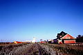
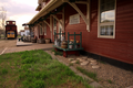
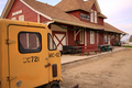
| Location | 115 Railway Avenue West Carlyle, Saskatchewan | ||||||||||
| Coordinates | 49°38′13″N102°16′13″W / 49.63682°N 102.2702°W | ||||||||||
| Platforms | 1 | ||||||||||
| History | |||||||||||
| Opened | 1909 | ||||||||||
| Former services | |||||||||||
| |||||||||||
| |||||||||||

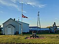
The Carlyle station is a former railway station in Carlyle, Saskatchewan. It was built by the Canadian National Railway in 1909 and later served Via Rail. It now houses the Rusty Relics Museum. [1]