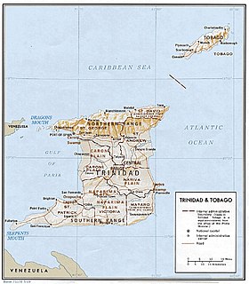
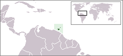
Trinidad and Tobago is an archipelagic republic in the southern Caribbean between the Caribbean Sea and the North Atlantic Ocean, northeast of Venezuela. They are southeasterly islands of the Lesser Antilles, Monos, Huevos, Gaspar Grande, Little Tobago, and St. Giles Island. Trinidad is 11 km (6.8 mi) off the northeast coast of Venezuela and 130 km (81 mi) south of the Grenadines. The island measures 4,768 km2 (1,841 sq mi) in area with an average length of 80 km (50 mi) and an average width of 59 km (37 mi). The island appears rectangular in shape with three projecting peninsular corners. Tobago is 30 km (19 mi) northeast of Trinidad and measures about 298 km2 (115 sq mi) in area, or 5.8% of the country's area, 41 km (25.5 mi) in length and 12 km (7.5 mi) at its greatest width. The island is cigar-shaped in appearance, with a northeast–southwest alignment.
The name Caroni may refer to:

Trinidad is the larger and more populous of the two major islands of Trinidad and Tobago. The island lies 11 km (6.8 mi) off the northeastern coast of Venezuela and sits on the continental shelf of South America. It is often referred to as the southernmost island in the West Indies. With an area of 4,768 km2 (1,841 sq mi), it is also the fifth largest in the West Indies.

The Borough of Chaguanas is the largest municipality and fastest-growing town in Trinidad and Tobago. Located in west-central Trinidad, south of Port of Spain, north of Couva and San Fernando, and named after the indigenous tribe who originally settled there, it grew in size due to its proximity to the Woodford Lodge sugar refinery. It remained a minor town until the 1980s when it began to grow rapidly as it drew people for its bargain shopping and moderately priced housing. Its rapid growth has seen property values increase dramatically, however.

The Northern Range is the range of tall hills across north Trinidad, the major island in the Republic of Trinidad and Tobago. The hills range from the Chaguaramas peninsula on the west coast to Toco in the east. The Northern Range covers approximately twenty-five percent of the land area of Trinidad.

Caroni County was a historic county of Trinidad and Tobago. It occupies 557 km2 (215 sq mi) in the west central part of the island of Trinidad, the larger island in the Republic of Trinidad and Tobago. It lies south and southwest of Saint George County, west of Nariva County and north of Victoria County. To the west it is bounded by the Gulf of Paria. County Caroni includes the towns of Chaguanas, the largest town in the country and Couva, the capital of the Couva–Tabaquite–Talparo region. Administratively it is divided between the Borough of Chaguanas, the Region of Couva–Tabaquite–Talparo and the Region of Tunapuna–Piarco. The county was divided into four Wards: Chaguanas, Couva, Cunupia and Montserrat. The major towns of County Caroni are Chaguanas and Couva. The port and industrial zone of Point Lisas is located in Caroni, and the region is also a site for agriculture.

The Nariva Swamp is the largest freshwater wetland in Trinidad and Tobago and has been designated a Wetland of International Importance under the Ramsar Convention. The swamp is located on the east coast of Trinidad, immediately inland from the Manzanilla Bay through Biche and covers over 60 square kilometres (23 mi2). The Nariva Swamp is extremely biodiverse. It is home to 45 mammal species, 39 reptile species, 33 fish species, 204 bird species, 19 frog species, 213 insect species and 15 mollusc species. All this contained in just 60 square kilometers.

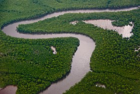
The Caroni Swamp is the second largest mangrove wetland in Trinidad and Tobago. It is located on the west coast of Trinidad, south of Port of Spain and northwest of Chaguanas, where the Caroni River meets the Gulf of Paria.

The Caroni River is the largest river in Trinidad and Tobago, running for 40 km (25 mi) from its origins in the Northern Range on the island of Trinidad, through the northern lowlands of the Caroni Plains and enters the Gulf of Paria at the Caroni Swamp.
Trinidad and Tobago are continental islands with a geologically very recent history of direct land bridge connection to South America. As a result, unlike most of the Caribbean Islands, Trinidad and Tobago supports a primarily South American flora and fauna and has greater diversity of plant and animal species than the Antilles. However, rates of endemism are lower than in the rest of the Caribbean because there has been less time for genetic isolation from mainland populations because of the history of land bridge connections and hence fewer opportunities for speciation, and so a greater proportion of the species in Trinidad and Tobago are also found on the South American mainland. Trinidad is nearer to mainland South America and has been directly connected to the mainland via land bridges more often and for longer periods than Tobago. This, as well as Trinidad's larger size and more varied topography and hydrology compared to that of Tobago allow greater species and ecosystem diversity on the former compared to that on the later of the islands.
Victoria was a county on Trinidad island in Trinidad and Tobago.
The counties of Trinidad and Tobago are historic administrative divisions of Trinidad and Tobago. Trinidad was divided into eight counties, and these counties were subdivided into wards. Tobago was administered as a ward of Saint David County.
Saint George is a county in Trinidad and Tobago. It occupies the northwestern portion of the island of Trinidad and is bounded by the Caribbean Sea to the north, the Gulf of Paria to the west, Caroni County to the south and Saint David County and Saint Andrew County to the east. It occupies an area of 912 km2 (352 sq mi). The county includes the Bocas Islands and the towns of Port of Spain and Arima. It also includes the small town of Blanchisseuse and its attractive beach, backed by a forest-fringed lagoon. County Saint George is divided into six Wards: Diego Martin, Saint Ann's, Blanchisseuse, Tacarigua, Arima and San Raphael.

The Central Range is a mountain range on the island of Trinidad. It extends diagonally across the island and is a low-lying range rising from swampy areas into rolling hills. The tallest hills in the range are Mount Tamana, Mount Harris and Brigand Hill; all located in the northeastern portion of the range. The Central Range mountains are biodiverse, and are home to the Tamana Caves - the site of Trinidad's largest bat roost. Howler monkeys can be found here and numerous species of birds as well.

Couva–Tabaquite–Talparo is one of the nine regions of Trinidad and Tobago, and one of the five regions which form the Gulf of Paria coastline on Trinidad's West Coast. Its regional capital and commercial center is Couva. Couva–Tabaquite–Talparo is the third-largest of Trinidad and Tobago's nine regions, with an area of 723 square kilometres (300 sq mi). As of 2011, the population was 178,410. The region is the second-most populous and fourth-least-densely populated region in Trinidad with 247 inhabitants per square kilometre (640/sq mi).
On the island of Trinidad, the Naparima Plain is a broad lowland area on the west between the Central Range and the Southern Range ; the lowland area on the east is the Nariva Plain. To the north of the Central Range is the Caroni Plain. The Oropouche river flows through the Naparima Plain and drains into the Oropouche Lagoon, a swampy area, on the Gulf of Paria coast. The northern region of the Naparima Plain has alluvial soil; the southern region is sandy and less fertile.
On the island of Trinidad, the Nariva Plain is a lowland area on the east between the Central Range and the Southern Range; the lowland area on the west is the Naparima Plain. To the north of the Central Range is the Caroni Plain. The lowland areas are either flat or consist of gently rolling hills. The eastern half of the island is not as thickly settled as the western. The 35-mile long Ortoire River flows eastward through the Nariva Plain and drains in the Nariva Swamp on the Atlantic Ocean coast.
On the island of Trinidad, the Southern Range is a discontinuous chain of low hills along the southern coast, reaching their highest altitude in the 1,000 feet (300 m) high Trinity Hills of the southeast. According to legend, the sight of the three neighboring hilltops of the then unnamed Trinity Hills, led to Christopher Columbus, on his third voyage to the New World, to name the island, "La Trinidad". The broad lowland area on the west between the Southern Range and the Central Range is the Naparima Plain; the lowland area on the east is the Nariva Plain. The Oropuche River flows through the Naparima Plain and drains into the Oropuche Lagoon, a swampy area, on the Gulf of Paria coast, whereas the 31-mile long Ortoire River flows through the Nariva Plain and drains into the Nariva Swamp on the Atlantic Ocean coast. The Southern region of the island has sandy and less fertile soil. The Southern Range, particularly its Western and Central parts, consists of unconsolidated segments.

The Trinidad mangroves ecoregion covers the separate mangrove forest areas on the coast of the island of Trinidad, in the country of Trinidad and Tobago. The character of the mangroves is affected by the large amount of fresh water flowing out of the Orinoco River and Amazon River to the south, which flow northwest around the island. The mangroves of Trinidad are found on all coasts, and are usually in the estuaries of rivers, but also found in coastal lagoons.