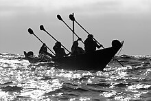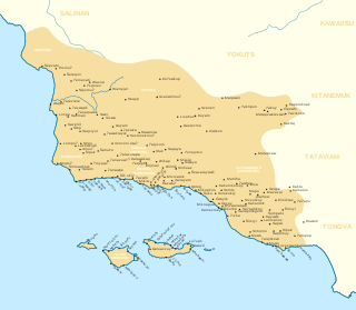
The Chumash are a Native American people of the central and southern coastal regions of California, in portions of what is now San Luis Obispo, Santa Barbara, Ventura and Los Angeles counties, extending from Morro Bay in the north to Malibu in the south. Their territory included three of the Channel Islands: Santa Cruz, Santa Rosa, and San Miguel; the smaller island of Anacapa was likely inhabited seasonally due to the lack of a consistent water source.

Carpinteria is a small seaside city in southeastern Santa Barbara County, California. Located on the Central Coast of California, it had a population of 13,264 at the 2020 census. Carpinteria is a popular surf destination; the city embraced the slogan "World's Safest Beach" in 1912, which it still uses today.
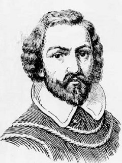
Juan Rodríguez Cabrillo was an Iberian maritime explorer best known for investigations of the West Coast of North America, undertaken on behalf of the Spanish Empire. He was the first European to explore present-day California, navigating along the coast of California in 1542–1543 on his voyage from New Spain.

Gaspar de Portolá y Rovira was a Spanish military officer, best known for leading the Portolá expedition into California and for serving as the first Governor of the Californias. His expedition laid the foundations of important Californian cities like San Diego and Monterey, and bestowed names to geographic features throughout California, many of which are still in use.

The Conejo Valley is a region spanning both southeastern Ventura County and northwestern Los Angeles County in Southern California, United States. It is located in the northwestern part of the Greater Los Angeles Area.
Pedro Fages (1734–1794) was a Spanish soldier, explorer, first Lieutenant Governor of the Californias under Gaspar de Portolá. Fages claimed the governorship after Portolá's death, acting as governor in opposition to the official governor Felipe de Barri, and later served officially as fifth (1782–91) Governor of the Californias.

Morro Rock is a volcanic plug in Morro Bay, California, on the Pacific Coast at the entrance to Morro Bay harbor. A causeway connects it with the shore, making it a tied island. The rock is protected as the Morro Rock State Preserve.

Joan Crespí or Juan Crespí was a Franciscan missionary and explorer of Las Californias.

The Portolá expedition was a Spanish voyage of exploration in 1769–1770 that was the first recorded European land entry and exploration of the interior of the present-day U.S. state of California. It was led by Gaspar de Portolá, governor of Las Californias, the Spanish colonial province that included California, Baja California, and other parts of present-day Mexico and the United States. The expedition led to the founding of Alta California and contributed to the solidification of Spanish territorial claims in the disputed and unexplored regions along the Pacific coast of North America.

El Presidio Real de San Diego is a historic fort in San Diego, California. It was established on May 14, 1769, by Gaspar de Portolá, leader of the first European land exploration of Alta California—at that time an unexplored northwestern frontier area of New Spain. The presidio was the first permanent European settlement on the Pacific Coast of the present-day United States. As the first of the presidios and Spanish missions in California, it was the base of operations for the Spanish colonization of California. The associated Mission San Diego de Alcalá later moved a few miles away.
José Francisco Ortega was an indigenous Californio soldier and early settler of Alta California. He joined the military at the age of twenty-one and rose to the rank of sergeant by the time he joined the Portola expedition in 1769. At the end of his military duty he would be granted land which he named Rancho Nuestra Senora del Refugio near Santa Barbara.
The Rancho Nuestra Señora del Refugio was a 74,000-acre (300 km2) Spanish land grant to José Francisco Ortega in 1794 and is the only land grant made under Spanish and confirmed by USA in 1866 to Jose Maria Ortega.under the US Supreme Court rule in what is today Santa Barbara County, California. A Mexican title was granted to Antonio Maria Ortega in 1834 by Mexican Governor José Figueroa. The grant extended along the Pacific coast from Cojo Canyon east of Point Conception, past Arroyo Hondo and Tajiguas Canyon, to Refugio Canyon, including what is now Gaviota Coast.

Saticoy is an unincorporated community in Ventura County, California, United States. The settlement was laid out in 1887 along the railroad line that was being built from Los Angeles through the Santa Clara River Valley to the town of San Buenaventura. Although the town was 10 miles (16 km) distant at that time, the City of Ventura grew to a point where the community is now just outside the city limits. For statistical purposes, the United States Census Bureau has defined Saticoy as a census-designated place (CDP).
Rancho Dos Pueblos was a 15,535-acre (62.87 km2) Mexican land grant in present day Santa Barbara County, California given in 1842 by Governor Juan Alvarado to Nicolas A. Den. The rancho stretched along the Pacific coast to the northwest of today's city of Santa Barbara, from Fairview Avenue in Goleta to the southeastern boundary of today's El Capitan State Beach. A 500-acre parcel was bought by Colin Powys Campbell in 1919. That parcel is now owned by University of California, Santa Barbara which purchased it from the Devereux Foundation in 2007, following the closure of the campus it had established there in 1945.
Rancho Punta de la Concepcion was a 24,992-acre (101.14 km2) Mexican land grant in the northern Santa Ynez Mountains, in present day Santa Barbara County, California. It was granted by Governor Juan Alvarado in 1837, to Anastacio Carrillo. The grant extended along the Pacific coast from Point Arguello south to Cojo Creek, just east of Point Conception.

Mescalitan Island was a mesalike island located about 10 miles west of Santa Barbara near the outlet of the Goleta Slough into the Pacific Ocean.

This timeline of the Portolá expedition tracks the progress during 1769 and 1770 of the first European exploration-by-land of north-western coastal areas in what became Las Californias, a province of Spanish colonial New Spain. Later, the region was administratively-split into Baja and Alta. The first section of the march was on the Baja California peninsula, and the northern section of the expedition's trail was in today's US state of California.

Burton Mound is a California Historical Landmark located in Santa Barbara, California, in the United States. It is believed to be a former Native American village that was discovered in 1542 by Juan Rodríguez Cabrillo. Historically known as Syujtun, it was also visited and documented by Juan Crespí, Gaspar de Portolà, and eventually Don Luís Burton, the latter who purchased the property in 1860. The California Department of Parks and Recreation has acknowledged that Burton Mound has "yielded some of the most important archeological evidence found in California".

The Portolá Trail Campsite or Portolá Trail Campsite No. 1 is the spot of the first Europeans to travel and camp overnight in what is now Central Los Angeles, California. The Portolá expedition camped at the site on August 2, 1769. The Portolá Trail Campsite No. 1 was designated a California Historic Landmark (No.655) on Sept. 26, 1958. The Portolá Trail Campsite is located in what is now the Elysian Park entrance, at the NW corner of North Broadway and Elysian Park Drive in the City of Los Angeles in Los Angeles County. The campsite is near the Los Angeles River, which they used as their water supply for the camp. Military officer Gaspar de Portolá was the commander of the expedition for the Spanish Empire with the goal of the Spanish colonization of the Americas. The expedition led to the founding of the first mission in the Los Angeles Basin, the Mission Vieja, on September 8, 1771 and of Alta California. The expedition arrived at Portolá Trail Campsite No. 1 from the San Gabriel Valley, were the Mission San Gabriel would be built later in 1776. As they depart Portolá Trail Campsite No. 1 they traveled west towards Santa Monica Bay, stopping at Portolá Trail Campsite 2, which is in present day Beverly Hills. Portolá Trail Campsite 2 is also a California Historic Landmark (No.665). At San Monica Bay the expedition turned and traveled north to were the future Mission San Fernando would be built in 1797. Form San Fernando the expedition turned west to Ventura, the site of the future Mission San Buenaventura built in 1782.
The Portolá Trail Campsite 2 or Portolá Trail Campsite No. 2 is the spot of the first Europeans to travel and camp overnight in what is now Beverly Hills, California. The Portolá expedition camped at the site on August 3, 1769. The Portolá Trail Campsite No. 2 was designated a California Historic Landmark (No.665) on Nov. 5, 1958. The Portolá Trail Campsite is located in what is now 325 South La Cienega Boulevard between Olympic Boulevard and Gregory, in Beverly Hills. in Los Angeles County. Military officer Gaspar de Portolá was the commander of the expedition for the Spanish Empire with the goal of the Spanish colonization of the Americas. The expedition led to the founding of the first mission in the Los Angeles Basin, the Mission Vieja, on September 8, 1771, and of Alta California. The expedition arrived at Portolá Trail Campsite No. 2 from the Portolá Trail Campsite No. 1 in what is now Elysian Park. They came to camp site 1 from the San Gabriel Valley, were the Mission San Gabriel would be built later in 1776. As they depart Portolá Trail Campsite No. 2 they traveled west towards Santa Monica Bay. At San Monica Bay the expedition turned and traveled north to were the future Mission San Fernando would be built in 1797. Form San Fernando the expedition turned west to Ventura, the site of the future Mission San Buenaventura built in 1782.