
Cabo Rojo is a city and municipality situated on the southwest coast of Puerto Rico and forms part of the San Germán–Cabo Rojo metropolitan area as well as the larger Mayagüez–San Germán–Cabo Rojo Combined Statistical Area.

Cabo da Roca or Cape Roca is a cape which forms the westernmost point of the Sintra Mountain Range, of mainland Portugal, of continental Europe, and of the Eurasian landmass. It is situated in the municipality of Sintra, near Azóia, in the south west of the Lisbon District. Notably, the point includes a lighthouse that started operation in 1772.
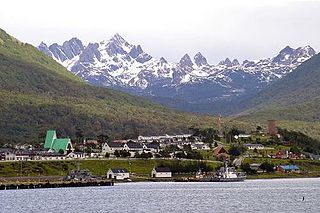
Puerto Williams is a city, port and naval base on Navarino Island in Chile, and is also the southernmost populated settlement in the world. It faces the Beagle Channel. It is the capital of the Chilean Antarctic Province, one of four provinces in the Magellan and Chilean Antarctica Region, and administers the communes of Chilean Antarctic Territory and Cabo de Hornos. It has a population of 2,874, including both naval personnel and civilians. Puerto Williams claims the title of world's southernmost city. The settlement was founded in 1953, and was first named Puerto Luisa. The town was later named after John Williams Wilson, a British man who founded Fuerte Bulnes, the first settlement in the Strait of Magellan. It has served primarily as a naval base for Chile. The Chilean Navy runs the Guardiamarina Zañartu Airport and hospital, as well as nearby meteorological stations. Since the late 20th century, the number of navy personnel has decreased in Puerto Williams and the civilian population has increased. In that period, tourism and support of scientific research have contributed to an increase in economic activity.

Costa da Morte is a part of the Galician coast. The most common definition of the Costa da Morte states that it extends from Cape Finisterre to Malpica, although some may debate it extends from Muros to A Coruña.

Los Cabos is a municipality located at the southern tip of Mexico's Baja California Peninsula, in the state of Baja California Sur. It encompasses the two towns of Cabo San Lucas and San José del Cabo linked by a thirty-two-km Resort Corridor of beach-front properties and championship golf courses.

La Manga, or La Manga del Mar Menor is a seaside spit of Mar Menor in the Region of Murcia, Spain.

Faro Los Morrillos de Cabo Rojo, also known as Los Morrillos Light, is a historic lighthouse located in Los Morrillos cape in the municipality of Cabo Rojo, Puerto Rico.

Cabo Polonio is a hamlet located in the eastern coast of Uruguay in the Rocha Department.

Cape Horn is the southernmost headland of the Tierra del Fuego archipelago of southern Chile, and is located on the small Hornos Island. Although not the most southerly point of South America, Cape Horn marks the northern boundary of the Drake Passage and marks where the Atlantic and Pacific Oceans meet.

Navarino Island is a Chilean island located between Isla Grande de Tierra del Fuego, to the north, and Cape Horn, to the south. The island forms part of the Commune of Cabo de Hornos, the southernmost commune in Chile and in the world, belonging to Antártica Chilena Province in the XII Region of Magallanes and Chilean Antarctica. Its population is concentrated primarily in the communal capital, Puerto Williams, and in small settlements like Puerto Navarino, Río Guanaco and Puerto Toro. The highest point of the island is Pico Navarino at 1,195 m (3,921 ft). The island is a popular destination for fly-fishers.

Alberto de Agostini National Park is a protected area that was created on January 22, 1965, on land that was formerly part of the "Hollanda" forest reserve and "Hernando de Magallanes National Park". It covers 1,460,000 hectares and includes the Cordillera Darwin mountain range, which is the final land-based stretch of the Andes before it becomes a chain of mountains appearing as small islands that sink into the Pacific Ocean and the Beagle Channel.

Hornos Island is a Chilean island at the southern tip of South America. The island is mostly known for being the location of Cape Horn. It is generally considered South America's southernmost island, but the Diego Ramírez Islands are farther south. The island is one of the Hermite Islands, part of the Tierra del Fuego archipelago.
Cape St. Vincent is a headland in the municipality of Vila do Bispo, in the Algarve, southern Portugal. It is the southwesternmost point of Portugal and of mainland Europe.
Cabo San Pío at 55°3′S66°31′W, the southernmost tip of mainland Isla Grande de Tierra del Fuego as well as of Argentina, except for the small islet Islote Blanco that lies about 1.5 kilometres (0.93 mi) off the coast in SW direction.

Cape Bojeador Lighthouse, also known as Burgos Lighthouse, is a cultural heritage structure in Burgos, Ilocos Norte, that was established during the Spanish colonial period in the Philippines. The lighthouse was first lit on March 30, 1892, and is set high on Vigia de Nagpartian Hill overlooking the scenic Cape Bojeador where early galleons used to sail by. After over 100 years, it still functions and serves ships that enter the Philippine archipelago from the north and guide them safely away from the rocky coast of the town.
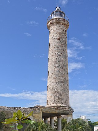
The Faro Vargas, also known as Faro de Cabo Cruz, is a staffed lighthouse located on the southernmost part of Cape Cruz in Cuba. Construction of the 32 metre lighthouse started in 1862 and was finished in 1871. The lighthouse has a height of 32 metres (105 ft), a focal height of 34 metres (112 ft) and emits one white flash every 5 seconds.

Cape Engaño Lighthouse, also known as Faro de Cabo Engaño, is a historic lighthouse located at Cape Engaño on Palaui Island in the town of Santa Ana, the province of Cagayan, Philippines. Located at the northernmost part of Luzon Island and situated atop the summit of a hill, 92 meters above sea level, the lighthouse provides a 360-degree view of Babuyan Island and the Dos Hermanas Island on the North, Pacific Ocean on the West and Engaño cove on the East.

Cape Espichel Lighthouse is situated on the western coast of the civil parish of Castelo, municipality of Sesimbra, in the Setúbal district of Portugal. The lighthouse was built in 1790.

Fort São Vicente is a military monument in Sagres, in the Algarve region of Portugal. It consists of the remains of a fortification, with a lighthouse inside. It was built in the 16th century to protect a coastal strip and an existing monastery on the site. In 1587 it was destroyed by British privateer Francis Drake, and rebuilt in 1606. In the mid-19th century, a lighthouse was built on the site, which was replaced by a new one in the early 20th century. In the mid-2000s, Cape São Vicente was closed to the public for construction work.

