Related Research Articles

Shinjuku-nishiguchi Station is a subway station on the Toei Oedo Line in Tokyo, Japan, operated by the Tokyo subway operator Toei Subway.

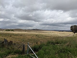
Lake Bathurst is a shallow lake located 27 kilometres (17 mi) south-east of Goulburn, New South Wales in Australia. It is also the name of a nearby locality in the Goulburn Mulwaree Council.

Ramla railway station is a railway station in Ramla, Israel, on the Tel Aviv–Beit Shemesh–Jerusalem line. The station is located in the east of Ramla. The station is also on a section shared with the Be'er Sheva–Tel Aviv line, which branches out in a southerly direction about 3 km east of Ramla.
The Parish of Nattery is a parish of Argyle County located between Goulburn and Marulan in New South Wales. It is just east of the village of Towrang and includes the locality of Carrick. The Wollondilly River is the boundary in the north-west. Jerraba creek is part of the boundary in the south-east. The Southern Highlands railway line runs through the northern end of the parish, to the east of the Wollondilly river. The Hume Highway passes through the middle of the parish.
Towrang is a closed railway station on the Main South railway line in New South Wales, Australia. A platform opened in the locality in 1869 south of the later station, called Mannafields after a property of the same name. A later station opened in 1874 north of the initial platform at 208 km south of Central, serving the small Southern highlands town of Towrang. It was an active station with a siding to load local agricultural produce. The station closed in 1974 and was demolished in the 1980s. Little evidence remains of the station, although two sets of points were later installed at the site to allow access to either track at times of track maintenance.
North Goulburn is a closed railway station on the Main South railway line in the town of Goulburn, New South Wales, Australia. It opened in 1882 and closed to passenger services in 1975. The privately owned red brick and sandstone Gatekeeper's cottage built in 1867, weatherboard signal box and platform all survive in good condition.
Murrays Flats was a railway station on the Main South railway line in New South Wales, Australia. It opened in 1888 and closed to passenger services in 1975.
Yarra was a railway station on the Main South railway line in New South Wales, Australia. It opened in 1875 initially as Collector and closed to passenger services in the 1970s. It was later completely demolished and no trace of the station now survives. East of the station is Joppa Junction, the junction of the Main South line and the Bombala line, which branches at Queanbeyan for Canberra.
Fish River was a small railway station on the Main South railway line in New South Wales, Australia. It opened in 1875 as part of the extension of the Great Southern line from Goulburn to Gunning and closed to passenger services in 1975. The signal box survived for a time after the platform was demolished, little trace of the station now survives.
Jerrawa was a small railway station, at the locality also known as Jerrawa, on the Main South railway line in New South Wales, Australia.
Argyle was a railway station on the Crookwell railway line, New South Wales, Australia. The station opened in 1902 with the opening of the line, and consisted of a 50 ft platform on the down side of the line. It gained its name from Argyle in Scotland, and was located adjacent to the Goulburn Training Centre.
Kenmore was a railway station on the Crookwell railway line, New South Wales, Australia. The station opened in 1902 with the opening of the line, and consisted of a 100 ft platform on the down side of the line. It gained its name from Kenmore a small village in Perthshire, Scotland, and was located adjacent to Kenmore Hospital. A 275 ft loop siding was constructed with the line, subsequently shortened in 1934 to 175 ft. In 1942, and additional siding was added. Passenger services ceased in 1974, and in 1975, the station and facilities closed and the platform was subsequently demolished. The line closed to goods traffic in 1984. The closed rail-line and loop remain in-situ.
The Norwood railway station was a railway station on the Crookwell railway line, New South Wales, Australia. The station opened in 1902 with the opening of the line, and consisted of a 30-metre (100 ft) platform on the down side of the line with a loop siding on the up side. The siding was removed in 1941 and the station closed in 1943 and was subsequently demolished. The line through Norwood closed to goods traffic in 1984.
The Forest was a railway station on the Crookwell railway line, New South Wales, Australia. The station opened in 1902 with the opening of the line, and consisted of a 100 ft platform on the down side of the line with a loop siding on the up side. It was named after an adjoining property named Forest Lodge. The platform was removed in 1969 and the loop closed in 1974 and was subsequently demolished. The line through The Forest closed to goods traffic in 1984.

Woodhouselee was a railway station on the Crookwell railway line, in Woodhouselee, New South Wales, Australia. The station opened in 1902 with the opening of the line, and consisted of a 100 ft platform on the up side of the line with a loop siding on the down side. It was named after a local resident Mr Woodhouse. The platform was closed in 1974 with the cessation of passenger services and subsequently demolished. The line through Woodhouselee closed to goods traffic in 1984, the loop has been removed but the mainline remains intact.

Roslyn was a railway station on the Crookwell railway line, New South Wales, Australia. The station opened in 1902 with the opening of the line, and consisted of a 100 ft platform on the down side of the line with a loop siding on the up side. Cattle loading facilities and goods sheds were also provided. It was named after the estate of a local resident Dr Mitchell. In 1925, the station became the location of the branch line to Taralga, with the new branch extending off the loop line.. The platform was shortened to 30 ft in 1969, and closed in 1974 with the cessation of passenger services. in 1975 the station and goods facilities were demolished. The line through Roslyn closed to goods traffic in 1984, and little remains at the site apart from the mainline track, the goods loading bank and the station master's residence.

Broxburn is a rural locality in the Toowoomba Region, Queensland, Australia. In the 2016 census Broxburn had a population of 153 people.

Tirrannaville is a locality in the Goulburn Mulwaree Council, New South Wales, Australia. It is located about 11 km south of Goulburn on the road to Braidwood. It was formerly called Terranna, which is the name of the parish covering most of the locality. The northern part of the defined locality, including the small settlement of Tirrannaville and cemetery, is in the parish of Goulburn. At the 2016 census, it had a population of 237. The locality mostly consists of grazing land.
Paget is a coastal suburb of Mackay in the Mackay Region, Queensland, Australia. In the 2016 census, Paget had a population of 273 people.
References
- ↑ Carrick station. NSWrail.net. Accessed 19 August 2009.
34°41′36″S149°52′51″E / 34.6934°S 149.8809°E
| | This article about a railway station in New South Wales is a stub. You can help Wikipedia by expanding it. |