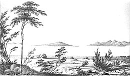
The Great Salt Lake is the largest saltwater lake in the Western Hemisphere and the eighth-largest terminal lake in the world. It lies in the northern part of the U.S. state of Utah and has a substantial impact upon the local climate, particularly through lake-effect snow. It is a remnant of Lake Bonneville, a prehistoric body of water that covered much of western Utah.
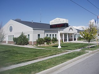
Grantsville is the second most populous city in Tooele County, Utah, United States. It is part of the Salt Lake City, Utah Metropolitan Statistical Area. The population was 12,617 at the 2020 census. The city has grown slowly and steadily throughout most of its existence, but rapid increases in growth occurred during the 1970s, 1990s, and 2010s. Recent rapid growth has been attributed to being close to Salt Lake City, small town community feel, lower housing costs than Salt Lake County, the nearby Deseret Peak recreational center, the Utah Motorsports Campus raceway, and the newly built Wal-Mart distribution center located just outside the city. It is quickly becoming a bedroom community for commuters into the Salt Lake Valley.

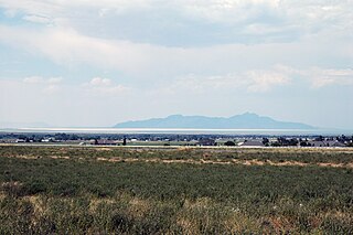
Tooele is a city in Tooele County in the U.S. state of Utah. The population was 35,742 at the 2020 census. It is the county seat of Tooele County. Located approximately 30 minutes southwest of Salt Lake City, Tooele is known for Tooele Army Depot, for its views of the nearby Oquirrh Mountains and the Great Salt Lake.

Utah Lake is a shallow freshwater lake in the center of Utah County, Utah, United States. It lies in Utah Valley, surrounded by the Provo-Orem metropolitan area. The lake's only river outlet, the Jordan River, is a tributary of the Great Salt Lake. Evaporation accounts for 42% of the lake's outflow, which leaves the lake slightly saline. The elevation of the lake is at 4,489 feet (1,368 m) above sea level. If the lake's water level rises above that, the pumps and gates on the Jordan River are left open. Recently the lake has been at a lower level because of a drought.

Lake Bonneville was the largest Late Pleistocene paleolake in the Great Basin of western North America. It was a pluvial lake that formed in response to an increase in precipitation and a decrease in evaporation as a result of cooler temperatures. The lake covered much of what is now western Utah and at its highest level extended into present-day Idaho and Nevada. Many other hydrographically closed basins in the Great Basin contained expanded lakes during the Late Pleistocene, including Lake Lahontan in northwestern Nevada.
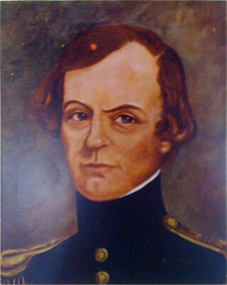
John Williams Gunnison was an American military officer and explorer.

Antelope Island ,with an area of 42 square miles (109 km2), is the largest of ten islands located within the Great Salt Lake in Utah. The island lies in the southeastern portion of the lake, near Salt Lake City and Davis County, and becomes a peninsula when the lake is at extremely low levels. It is protected as Antelope Island State Park.
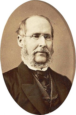
Albert Carrington was an apostle and member of the Quorum of the Twelve Apostles and First Presidency of the Church of Jesus Christ of Latter-day Saints.

The Deseret Peak Wilderness is located in the Stansbury Mountains of Tooele County, Utah, United States near the towns of Tooele and Grantsville, not far from the Great Salt Lake. It is part of the Wasatch-Cache National Forest. This semi-arid wilderness is part of the Great Basin ecosystem. Elevations range from about 6,000 feet to the top of Deseret Peak's limestone escarpment at 11,031 feet (3,362 m). In this high country, with barren Skull Valley to the west, you'll find some springs and intermittent creeks, despite the general dryness of the area.

The Salt Lake City Cemetery is a cemetery in northeastern Salt Lake City, Utah, United States, that is one of the largest city-operated cemeteries in the United States.
Deseret Peak is the highest peak in the Stansbury Mountains with an elevation of 11,035 ft. It is located in the Deseret Peak Wilderness area west of Grantsville, Utah and east of Skull Valley Indian Reservation. It is the fourth most topographically prominent peak in the state of Utah. The site is a popular destination for hikers and backcountry skiers as the area is a contrast of the alpine wilderness with the surrounding desert basin. The trail that leads to the peak is easily accessible from Salt Lake City. The mountain offers views of the Bonneville Salt Flats, the Great Salt Lake, and the surrounding towns and mountain ranges. On a clear day, it is possible to see Mount Nebo, the highest peak in the adjacent Wasatch Mountains.

Gunnison Island is located in the northwest quadrant of the Great Salt Lake in Box Elder County, Utah, United States, approximately 55 miles (89 km) northwest of Salt Lake City and about 6 miles (9.7 km) east from the lake's western shore, and is best known as an important rookery for the American white pelican. The California gull also nests on the island, and occasional nesters include the great blue heron, common raven, prairie falcon, and rock wren.

The Promontory Mountains are a range in Box Elder County, Utah. The range is oriented north–south and has a length of about 35 miles (56 km). The southern portion forms a cape extending 20 miles (32 km) south into the Great Salt Lake. The First transcontinental railroad was completed with the Golden Spike just north of the range at Promontory Summit in the Utah Territory. Today, trains cross the Promontory Point at the southern tip of the range via the Lucin Cutoff railroad causeway across the lake.

Fremont Island is a 2,943.04-acre (11.91 km2) island located in Great Salt Lake in northern Utah, United States. State owned, it is the lake's third largest island after Stansbury Island and Antelope Island. The island has also been known by several other names, including mo'ko-mom-bĭtc, Castle Island, Coffin Island, Disappointment Island, and Miller Island.
Stansbury Island is the second largest island within the Great Salt Lake in the U.S. state of Utah. Located in Tooele County, it is considered an island even though a dirt causeway connects it to the mainland. Stansbury Island was named after Howard Stansbury, the leader of a government expedition that surveyed the lake in 1849.
Howard Stansbury was a major in the U.S. Army Corps of Topographical Engineers. His most notable achievement was leading a two-year expedition (1849–1851) to survey the Great Salt Lake and its surroundings. The expedition report entitled Exploration and survey of the valley of the Great Salt Lake of Utah, including a reconnaissance of a new route through the Rocky Mountains was published in 1852 providing the first serious scientific exploration of the flora and fauna of the Great Salt Lake Valley as well as a favorable impression of the members of the Church of Jesus Christ of Latter-day Saints, who had settled there beginning in 1847.

The Stansbury Mountains are a 28-mile (45 km) long mountain range located in eastern Tooele County, Utah. It is named for U.S. Army Major Howard Stansbury, a topographical engineer, who led an expedition that surveyed the region.
Skull Valley is a 40-mile (64 km) long valley located in east Tooele County, Utah, United States at the southwest of the Great Salt Lake. The valley trends north–south, but turns slightly northeast to meet Stansbury Bay,.
The Salt Lake City Radar Bomb Scoring Site is a Formerly Used Defense Site that was an automatic tracking (AUTOTRACK) radar station during the Cold War. Operated by Detachment 6 of the 11th Radar Bomb Scoring Squadron which had relocated from the Phoenix semi-mobile RBS station in December 1964, the military installation evaluated practice bomb runs by Strategic Air Command simulating attacks on the metropolitan area and on the Hill Air Force Range which had been the Salt Lake City Army Air Base Gunnery Range in World War II.