
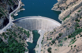
Glen Canyon Dam is a concrete arch-gravity dam in the southwestern United States, located on the Colorado River in northern Arizona, near the town of Page. The 710-foot-high (220 m) dam was built by the Bureau of Reclamation (USBR) from 1956 to 1966 and forms Lake Powell, one of the largest man-made reservoirs in the U.S. with a capacity of more than 25 million acre-feet (31 km3). The dam is named for Glen Canyon, a series of deep sandstone gorges now flooded by the reservoir; Lake Powell is named for John Wesley Powell, who in 1869 led the first expedition to traverse the Colorado River's Grand Canyon by boat.

Horsetooth Reservoir is a large reservoir in southern Larimer County, Colorado, in the foothills just west of the city of Fort Collins, Colorado. The reservoir runs north-south for approximately 6.5 miles (10 km) and is approximately one-half mile (1 km) wide. Its shape and orientation are the result of the fact that the main body of the reservoir is contained between several homoclinal ridges. A ridge composed of Dakota sandstone runs along the east side where gaps in the ridge are plugged by dams. On the west (uphill) side there are two prominent ridges topped by erosion-resistant sandstones of the Lyons and Ingleside formations. Gaps in these ridges have created a handful of bays and coves the largest of which is Inlet Bay, home to a marina and campgrounds.

New Melones Dam is an earth and rock filled embankment dam on the Stanislaus River, about 5 miles (8.0 km) west of Jamestown, California, United States, on the border of Calaveras County and Tuolumne County. The water impounded by the 625-foot-tall (191 m) dam forms New Melones Lake, California's fourth-largest reservoir, in the foothills of the Sierra Nevada east of the San Joaquin Valley. The dam serves mainly for irrigation water supply, and also provides hydropower generation, flood control, and recreation benefits.

The Colorado–Big Thompson Project is a federal water diversion project in Colorado designed to collect West Slope mountain water from the headwaters of the Colorado River and divert it to Colorado's Front Range and plains. In Colorado, approximately 80% of the state's precipitation falls on the West Slope, in the Rocky Mountains, while around 80% of the state's growing population lives along the eastern slope, between the cities of Fort Collins and Pueblo.

Flaming Gorge Dam is a concrete thin-arch dam on the Green River, a major tributary of the Colorado River, in northern Utah in the United States. Flaming Gorge Dam forms the Flaming Gorge Reservoir, which extends 91 miles (146 km) into southern Wyoming, submerging four distinct gorges of the Green River. The dam is a major component of the Colorado River Storage Project, which stores and distributes upper Colorado River Basin water.
Strawberry Reservoir is a large reservoir in the U.S. state of Utah. It is Utah's most popular fishery, receiving over 1.5 million angling hours annually and is part of the Blue Ribbon Fisheries program. Game fish in the reservoir include sterilized rainbow trout, bear lake cutthroat trout, kokanee salmon and crayfish. It is located 23 miles (37 km) southeast of Heber, Utah on U.S. Route 40. The reservoir is situated in Strawberry Valley. This valley is normally part of the Colorado River drainage. The dam was constructed to divert water into Utah Valley.
Monticello Dam is a 304-foot (93 m) high concrete arch dam in Napa County, California, United States, constructed between 1953 and 1957. The dam impounded Putah Creek to create Lake Berryessa in the Vaca Mountains.

Navajo Dam is a dam on the San Juan River, a tributary of the Colorado River, in northwestern New Mexico in the United States. The 402-foot (123 m) high earthen dam is situated in the foothills of the San Juan Mountains about 44 miles (71 km) upstream and east of Farmington, New Mexico. It was built by the U.S. Bureau of Reclamation (Reclamation) in the 1960s to provide flood control, irrigation, domestic and industrial water supply, and storage for droughts. A small hydroelectric power plant was added in the 1980s.

Yellowtail Dam is a dam across the Bighorn River in south central Montana in the United States. The mid-1960s era concrete arch dam serves to regulate the flow of the Bighorn for irrigation purposes and to generate hydroelectric power. The dam and its reservoir, Bighorn Lake, are owned by the U.S. Bureau of Reclamation.

Green Mountain Reservoir lies at the northern end of Summit County, Colorado along the Blue River. The Green Mountain Dam was built between 1938 and 1942 by the United States Bureau of Reclamation. The reservoir and its dam store water to benefit Colorado's Western Slope. Created by President Roosevelt as part of the Colorado-Big Thompson Project in 1937, Green Mountain was the first facility to be constructed. This is because it represents a great compromise that made the C-BT project possible: it compensates the Western Slope for water diverted to cities in Northern Colorado from Lake Granby further upstream on the Colorado River. Water from Green Mountain Dam is released either over the spillway, through the dam, or through the hydroelectric powerplant at the dam's base. The Green Mountain Power Plant has the capacity to generate up to 21,000 kilowatts, using two generators. Combined with the other five Federal power plants on the C-BT, enough electricity is produced annually to power almost 60,000 American homes.

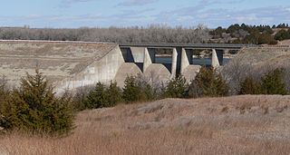
Pactola Dam is an embankment dam on Rapid Creek in Pennington County, South Dakota, about 10 miles (16 km) west of Rapid City. The dam was completed in 1956 by the U.S. Bureau of Reclamation to provide flood control, water supply and recreation. Along with the nearby Deerfield Dam, it is part of the Rapid Valley Unit of the Pick-Sloan Missouri Basin Program. U.S. Route 385 runs along the crest of the dam. The dam forms Pactola Lake, which at over 1,200 acres (490 ha) is the largest and deepest body of water in the Black Hills.

Sugar Loaf Dam is a dam in Lake County of mid-Colorado, 4 miles (6.4 km) west of Leadville.

Crawford Dam impounds water for Crawford Reservoir in Delta County, Colorado about a mile south of the town of Crawford. The earthen dam was completed in 1962 by the United States Bureau of Reclamation with a height of 162 feet (49 m) and 580 feet (180 m) long at its crest. It impounds Iron Creek for irrigation flood control, one element of the Smith Fork Project. The dam is owned by the Bureau and operated by the local Crawford Water Conservancy District. When full, Crawford Reservoir has a water surface area of 406 acres (164 ha), about 7 miles (11 km) of shoreline, and a total capacity of 14,395 acre-feet (17,756,000 m3). The main purpose of the facility is to provide farm irrigation, and the size of Crawford Reservoir changes significantly with the seasons. In most years, the lake is full in late Spring and early Summer, but by early Fall, the water level drops enough to leave boat launches high and dry. The low water pool lasts through the Winter until Spring runoff begins to fill the water supply once again.
The reservoir is encompassed within Crawford State Park with Park Headquarters located on a peninsula along the northeastern shore. Recreation opportunities include fishing, boating, camping on 66 campsites, picnicking, swimming, and hiking.

Prosser Creek Dam is a dam in Nevada County, California.
Medicine Creek Dam is a dam in Frontier County, Nebraska.
Twin Lakes Dam is a dam in Lake County, Colorado, about 13 miles (21 km) south of Leadville.

Bonny Dam is a dam in Yuma County, Colorado, in the eastern part of the state.
Willow Creek Dam is a dam in Lewis and Clark County, Montana.
Conconully Dam is a dam in Okanogan County, Washington, United States.

Willow Creek Dam is a dam in Grand County, Colorado.


