
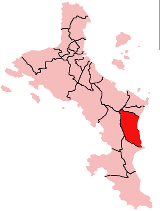
Takamaka is one of the 26 administrative regions of Mahé, Republic of Seychelles. It is located on the southern part of the island of Mahé. Three other districts cover the two other main islands of the Republic, Grand' Anse and Baie Sainte Anne on the island of Praslin and the inner islands district which comprise the 3rd largest island, La Digue. The population of Takamata is estimated at around 3,000.

Anse Boileau is an administrative district on the south of the island of Mahé in the Seychelles. Anse Boileau encapsulates the natural wonders of the Seychelles: it sits at the foot of a steep, green mountain, it is on the shores of the Indian Ocean, and in its midst are streams, mini-forests, creeks, ponds, and an enchanting array of all that defines the Seychellois landscape. It is often described as a fishing village because many of the local residents fish for a living. It has a school, a restaurant, a number of grocery shops, a health centre, and a police station. It is a short distance away from Anse La Mouche, a popular tourist destination. Anse Boileau is so-called because of its many coves.

Grand'Anse Mahé is an administrative district of Seychelles located on the island of Mahé.

Anse aux Pins is an administrative district of Seychelles located on the island of Mahé. Soleil Island is part of the district.

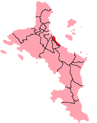
Anse Etoile is an administrative district of Seychelles on the island of Mahé.
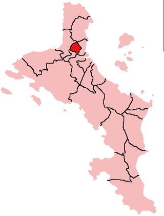
Au Cap is an administrative district of Seychelles located on the island of Mahé.
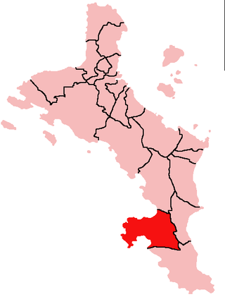
Baie Lazare is an administrative district of Seychelles located on the island of Mahé. It is named after the explorer Lazare Picault.

Grand'Anse Praslin is an administrative district of Seychelles located mostly on the island of Praslin, but also administers Cousin Island, Cousine Island, Booby Island, and Aride Island.
Bel Air is an administrative district of Seychelles located on the island of Mahé.

Bel Ombre is an administrative district of Seychelles located on the island of Mahé. It has a small fishing harbour for artesan fishing from small boats with lines.

Glacis is an administrative district of Seychelles located in the North Region of the island of Mahé. It also encompasses uninhabited Mamelles Island 13 kilometers to the northeast of Mahé, and the tiny Brisan Rocks in between.

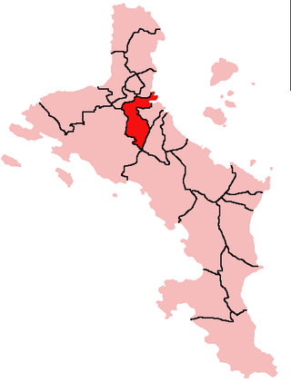
English River is an administrative district of Seychelles on the island of Mahé.

Port Glaud is an administrative district of Seychelles located on the northwestern coast of the island of Mahé. It is 25 km² and has a population of 2174. The main village is Port Glaud. The district contains two marine parks; Bay Ternay & Port Launay. The offshore islands of Thérèse Island and Conception Island are part of Port Glaud District.
Roche Caïman is an administrative district of Seychelles located on the island of Mahé. It has a football stadium where its national team play most of the home matches.
Mont Buxton is an administrative district of Seychelles located on the island of Mahé.

Mont Fleuri is an administrative district of Seychelles with its main part located on the island of Mahé. It also includes the six islands of the Sainte Anne Marine National Park and two islets further east.

Saint Louis is an administrative district of Seychelles located on the island of Mahé. It is the smallest district of Seychelles with an area slightly more than a square kilometer.

Pointe La Rue is an administrative district of Seychelles located in the eastern region of the island of Mahé.

Les Mamelles is an administrative district of the Seychelles, located in the south of the Greater Victoria (suburban) area on Mahé, the main island of the archipelago. The district is located inward from the adjacent coastal district of Roche Caiman. It is not to be confused with Mamelles Island some 13 kilometers northeast of Mahé.

Plaisance is an administrative district of Seychelles located on the island of Mahé.

