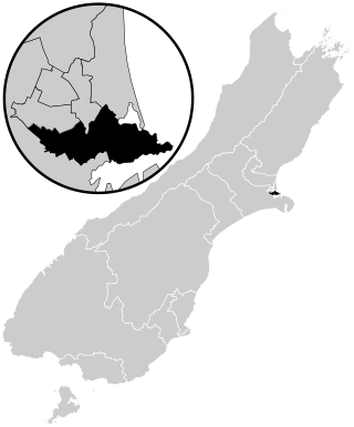
Christchurch is the largest city in the South Island and the second-largest city by urban area population in New Zealand, after Auckland. Christchurch lies in the Canterbury Region, near the centre of the east coast of the South Island, east of the Canterbury Plains. It is located near the southern end of Pegasus Bay, and is bounded to the east by the Pacific Ocean and to the south by Banks Peninsula. The Avon River / Ōtākaro flows through the centre of the city, with a large urban park along its banks. Christchurch has a reputation for being an 'English' city, with its architectural identity and common nickname the "Garden City" due to similarities with garden cities in England.

Opawa is an inner residential suburb of Christchurch, New Zealand. It is located approximately 3.5 kilometres south-east of the city centre. Initally Opawa was a low-lying area, and a continuation of the Sydenham swamp. By the 1860s, the area was sparsely populated by European settlers and later became a rural-agricultural locality, with many of the early settlers of English descent. As Woolston emerged as an industrial hub nearby, Opawa was heavily urbanised, transforming it into an upscale residential area and its population largely included factory workers and businesspeople. Notable heritage-listed buildings in the suburb include "Risingholme" and "The Hollies". In its formative days, Opawa was a riding of the Heathcote County Council. It later amalgamated in to the city area in 1916.

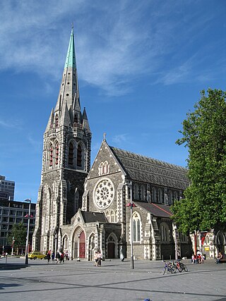
ChristChurch Cathedral, also called Christ Church Cathedral and (rarely) Cathedral Church of Christ, is a deconsecrated Anglican cathedral in the city of Christchurch, New Zealand. It was built between 1864 and 1904 in the centre of the city, surrounded by Cathedral Square. It became the cathedral seat of the Bishop of Christchurch, who is in the New Zealand tikanga of the Anglican Church in Aotearoa, New Zealand and Polynesia.

Cashmere is a suburb which rises above the southern end of the city of Christchurch in New Zealand's South Island, on the north side of the Port Hills. It covers an area of 4.71 km2 (1.82 sq mi) and has a population of 6,453 as at 2018.

Cashmere High School is a state coeducational secondary school, located in southern Christchurch, New Zealand. It was opened in 1956 in response to population growth in southern Christchurch during the 1950s.

Rangi Ruru Girls' School is a New Zealand private girls' day and boarding secondary school located in Merivale, an inner suburb of Christchurch. The school is affiliated with the Presbyterian Church and serves approximately 704 girls from Years 7 to 13.
St Martins is an inner suburb of Christchurch, New Zealand, located two kilometres south of the city centre. Primarily a residential area, St Martins is host to a small shopping mall complex situated on Wilsons Road, the main thoroughfare through the suburb.

The Christchurch City Council is the local government authority for Christchurch in New Zealand. It is a territorial authority elected to represent the 396,200 people of Christchurch. Since October 2022, the Mayor of Christchurch is Phil Mauger, who succeeded after the retirement of Lianne Dalziel. The council currently consists of 16 councillors elected from sixteen wards, and is presided over by the mayor, who is elected at large. The number of elected members and ward boundaries changed prior to the 2016 election.

Port Hills was a parliamentary electorate of New Zealand that existed for the 2008 through 2017 general elections. Ruth Dyson of the Labour Party had previously held the Banks Peninsula electorate since the 1999 election that was largely replaced by Port Hills, and held Port Hills for its entire existence before retiring ahead of the 2020 election. The Port Hills electorate was mostly urban, and lost the more rural Banks Peninsula areas of the old electorate to the Selwyn electorate that was also formed for the 2008 election.
The 2010 Canterbury earthquake struck the South Island of New Zealand with a moment magnitude of 7.1 at on 4 September, and had a maximum perceived intensity of X (Extreme) on the Mercalli intensity scale. Some damaging aftershocks followed the main event, the strongest of which was a magnitude 6.3 shock known as the Christchurch earthquake that occurred nearly six months later on 22 February 2011. Because this aftershock was centred very close to Christchurch, it was much more destructive and resulted in the deaths of 185 people.

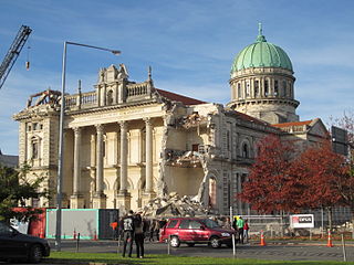
A major earthquake occurred in Christchurch on Tuesday 22 February 2011 at 12:51 p.m. local time. The 6.2 earthquake struck the Canterbury region in the South Island, centred 6.7 kilometres (4.2 mi) south-east of the central business district. It caused widespread damage across Christchurch, killing 185 people in New Zealand's fifth-deadliest disaster.

St Paul's Church was a heritage-listed former Presbyterian church in Cashel Street, Christchurch. Built in 1877, the church was registered by the New Zealand Historic Places Trust as a Category I heritage building. Following the February 2011 Christchurch earthquake, the building was removed from the heritage list and demolished.

Governors Bay is a small town in Canterbury, New Zealand.

City Mall is the main pedestrian mall in the central city of Christchurch, New Zealand, comprising two sections of Cashel Street plus the Bridge of Remembrance and one section of High Street. It is also known colloquially as Cashel Mall. The Bridge of Remembrance was pedestrianised in 1976. The main mall was closed to traffic on 11 January 1982 and formally reopened as a pedestrian mall on 7 August, but it was not until 1992 that the entire mall was paved. The mall was redeveloped between 2006 and 2009, and track was installed for an expansion of the heritage tram network.

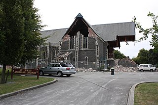
St Luke's Church was an Anglican church located in Christchurch, New Zealand. The former church was built on one of the five sites set aside in the central city in the original survey of Christchurch for the Anglican church and the building was registered as a Category II historic place with the New Zealand Historic Places Trust. Following sustained damage caused by the February 2011 Christchurch earthquake, the building was demolished in July 2011.

TheTrinity Church or Trinity Congregational Church designed by Benjamin Mountfort, later called the State Trinity Centre, is a Category I heritage building listed with Heritage New Zealand. Damaged in the 2010 Canterbury earthquake and red-stickered after the February 2011 Christchurch earthquake, the building was threatened with demolition like most other central city heritage buildings. In June 2012, it was announced that the building would be saved, repaired and earthquake strengthened. The building, post its church status, has housed some commercial operations, including the State Trinity Centre; 'The Octagon' (2006–2010); and later, following earthquake repairs, a business called 'The Church Brew Pub' (2023–present).

Leonard Roy Lovell-Smith was a New Zealand architect.

St Peter's Church is an Anglican church in Riccarton, Christchurch, New Zealand. It is registered as Category II by Heritage New Zealand.


