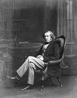
James Orchard Halliwell-Phillipps was an English Shakespearean scholar, antiquarian, and a collector of English nursery rhymes and fairy tales.
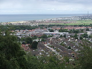
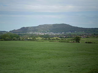
Abergele is a market town and community, situated on the north coast of Wales between the holiday resorts of Colwyn Bay and Rhyl, in Conwy County Borough and in the historic county of Denbighshire. Its northern suburb of Pensarn lies on the Irish Sea coast. Abergele and Pensarn railway station serves both resorts. Abergele is often overlooked due to the popularity of towns in nearby Rhyl, Prestatyn, Colwyn Bay, Llandudno and Conwy. Only 46.5% of the population was born in Wales as of the 2011 census.

Yr Eifl, sometimes called the Rivals in English, is a group of hills on the north coast of the Llŷn Peninsula in Gwynedd, Wales.
The Castle of Dinerth is a Welsh castle located near Aberarth, Ceredigion, west Wales that was completed c. AD 1110. It is also known as Hero Castle, presumably from the Norse hiro.

Margam Country Park is a country park estate in Wales, of around 850 acres (3.4 km²). It is situated in Margam, about 2 miles (3 km) from Port Talbot in south Wales. It was once owned by the Mansel Talbot family and is now owned and administered by the local council, Neath Port Talbot County Borough Council. Situated within the park are three notable buildings: Margam Abbey, a Cistercian monastery; Margam Castle, a neo-Gothic country house that was once the seat of the Mansel Talbot family; and the 18th-century Orangery.

The Clwydian Range is a series of hills in the north-east of Wales that runs from Llandegla in the south to Prestatyn in the north, the highest point being the popular Moel Famau. The range forms part of the Clwydian Range and Dee Valley Area of Outstanding Natural Beauty.

Sychnant Pass in Conwy County Borough, Wales, links Conwy to Penmaenmawr via Dwygyfylchi. Much of the pass is in Snowdonia National Park, and a large area of land within it has been designated a Site of Special Scientific Interest. At the bottom is the village of Capelulo, which lends its name to the community of Penmaenmawr.

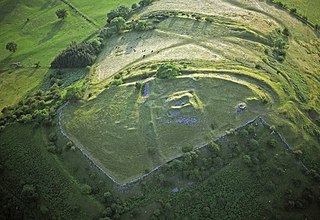
Tre'r Ceiri is a hillfort dating back to the Iron Age. The name means 'town of the giants', from cewri, plural of cawr, 'giant'. The settlement is located 450 metres (1,480 ft) above sea level on the slopes of Yr Eifl, a mountain on the north coast of the Llŷn Peninsula in Gwynedd, north-western Wales. Evidence suggests the settlement was first built around 200 BC, though most of the archaeological finds date from AD 150–400, showing the site continued as a settlement during the Roman occupation.

Breidden Hill is an extinct volcanic hill in Powys, Wales, near the town of Welshpool. It is immediately surrounded by the villages of Trewern, Middletown, Criggion, Crew Green and Llandrinio. The peak of the hill reaches to 367 metres (1,204 ft). Footpaths which lead up to the summit provide excellent 360 degree views over Powys and over the border with England to the Shropshire Plain.
Castell Dinas is a hillfort and castle in southern Powys, Wales. At 450 m (SO179301) it has the highest castle in England and Wales. It is positioned to defend the Rhiangoll pass between Talgarth and Crickhowell.

Mynydd y Dref or Conwy Mountain is a hilly area to the west of the town of Conwy, in North Wales. To the north it overlooks the sea of Conwy Bay, and to the south lie the foothills of the Carneddau range of mountains, of which it forms a part. Mynydd y Dref is the remains of an ancient volcano that erupted about 450 million years ago.
The Celtic Way is a long-distance walk from West Wales, through South Wales and into Wessex and the West of England in the United Kingdom. The route is 725-mile-long (1,167 km) and visits more than one hundred pre-historic sites through its route.
Gaer is the name of a hill in the Black Mountains of the Brecon Beacons National Park in Monmouthshire, south Wales. It lies at the southern end of the long ridge between the valley of the Grwyne Fawr and the Vale of Ewyas one mile to the north of Bryn Arw and 3 miles northeast of Sugarloaf. Its summit at 427m above sea level sits within an Iron Age hillfort known as Twyn y Gaer.

Moel y Gaer is an Iron Age hillfort located on a summit at the southern end of Halkyn Mountain, overlooking the village of Rhosesmor, Flintshire, Wales. It is a well-preserved hillfort overlooking the Dee Estuary. Excavations in the early 1970s revealed a sequence of defensive structures made of timber and several phases of building work inside the ramparts.

Castell Bryn Gwyn is a prehistoric site on the Isle of Anglesey, west of Brynsiencyn. It is a circular clay and gravel bank covered with grass, still some 1.5m high and revetted externally by stone walls, which surround a level area some 54 metres in diameter. Its name means "White Hill Castle".

Trencrom Hill is a prominent hill fort, owned by the National Trust, near Lelant, Cornwall. It is crowned by an univallate Neolithic tor enclosure and was re-used as a hillfort in the Iron Age. Cairns or hut circles can be seen in the level area enclosed by the stone and earth banks. The hill overlooks the Hayle Estuary and river, and Mount's Bay and St Michael's Mount can be seen to the south. The hill was recorded as Torcrobm in 1758 which is derived from Cornish "torr crobm", i.e. 'hunched bulge'.
Coed y Gopa is a Site of Special Scientific Interest in the preserved county of Clwyd, north Wales.
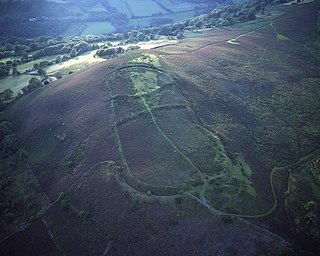
Moel Hiraddug, also known as Y Foel, is a hill fort and hill in the Clwydian Range of north-east Wales. The northern part of the hill has been eaten away by limestone quarrying. An Iron Age hillfort crowns the hill, called Moel Hiraddug. Its ridge runs North-South and it lies above the village of Dyserth. The views from the top are extensive and include Snowdonia. It is 265 metres above sea level.

Bedd-y-Cawr Hillfort, or Bedd y Cawr Hillfort, is an Iron Age hillfort on a natural inland promontory in the community of Cefnmeiriadog in Denbighshire in North Wales. The name of the hillfort translates from the Welsh as Giant's Tomb.
