
The Fraser River is the longest river within British Columbia, Canada, rising at Fraser Pass near Blackrock Mountain in the Rocky Mountains and flowing for 1,375 kilometres (854 mi), into the Strait of Georgia just south of the City of Vancouver. The river's annual discharge at its mouth is 112 cubic kilometres (27 cu mi) or 3,550 cubic metres per second (125,000 cu ft/s), and each year it discharges about 20 million tons of sediment into the ocean.

Mount Garibaldi is a dormant stratovolcano in the Garibaldi Ranges of the Pacific Ranges in southwestern British Columbia, Canada. It has a maximum elevation of 2,678 metres and rises above the surrounding landscape on the east side of the Cheakamus River in New Westminster Land District. In addition to the main peak, Mount Garibaldi has two named sub-peaks. Atwell Peak is a sharp, conical peak slightly higher than the more rounded peak of Dalton Dome. Both were volcanically active at different times throughout Mount Garibaldi's eruptive history. The northern and eastern flanks of Mount Garibaldi are obscured by the Garibaldi Névé, a large snowfield containing several radiating glaciers. Flowing from the steep western face of Mount Garibaldi is the Cheekye River, a tributary of the Cheakamus River. Opal Cone on the southeastern flank is a small volcanic cone from which a lengthy lava flow descends. The western face is a landslide feature that formed in a series of collapses between 12,800 and 11,500 years ago. These collapses resulted in the formation of a large debris flow deposit that fans out into the Squamish Valley.

The Stikine River is a major river in northern British Columbia (BC), Canada and southeastern Alaska in the United States. It drains a large, remote upland area known as the Stikine Country east of the Coast Mountains. Flowing west and south for 610 kilometres (379 mi), it empties into various straits of the Inside Passage near Wrangell, Alaska. About 90 percent of the river's length and 95 percent of its drainage basin are in Canada. Considered one of the last truly wild large rivers in BC, the Stikine flows through a variety of landscapes including boreal forest, steep canyons and wide glacial valleys.

The Cheakamus River is a tributary of the Squamish River, beginning at the terminus of McBride Glacier on Mount Sir Richard in Garibaldi Provincial Park upstream from Cheakamus Lake on the southeastern outskirts of the resort area of Whistler. The river flows into Cheakamus Lake before exiting it and flowing northwest until it turns south and enters Daisy Lake. Between the outlet of Daisy Lake and its mouth, much of its length is spent going through Cheakamus Canyon, where the river flows through swift rapids and even one good sized waterfall. The river flows south from the lake and through the canyon before joining the Squamish River at Cheekye, a few miles north of the town of Squamish. The river's name is an anglicization of the name of Chiyakmesh, a village of the Squamish people and a reserve of the Squamish Nation.
Erg Mountain Provincial Park is a provincial park in British Columbia, Canada.

The Purcell Wilderness Conservancy is a provincial park in British Columbia, Canada. It was established in 1974, and encompasses six large drainages in the Purcell Mountains in the southeast of the province. It contains high peaks, alpine meadows and ridges, deep creek and river valleys, and hot springs at Dewar Creek.

Strathcona Provincial Park is the oldest provincial park in British Columbia, Canada, and the largest on Vancouver Island. Founded in 1911, the park was named for Donald Alexander Smith, 1st Baron Strathcona and Mount Royal, a wealthy philanthropist and railway pioneer. It lies within the Strathcona Regional District. The Clayoquot Sound Biosphere Reserve, established in 2000, includes three watersheds in the western area of the park.
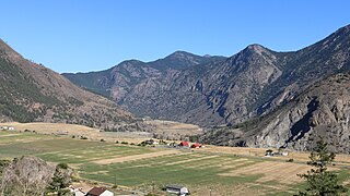
Tête Jaune Cache is an unincorporated rural area and the site of an important abandoned historic town in British Columbia, Canada. Its population is approximately 500. It is on the Fraser River in the Robson Valley at the intersection of Yellowhead Highways 5 and 16. Tête Jaune Cache is located 18 km north of Valemount, B.C., 101 km west of Jasper, Alberta, 241 km east of Prince George, B.C., and 332 km north of Kamloops, B.C., by road.

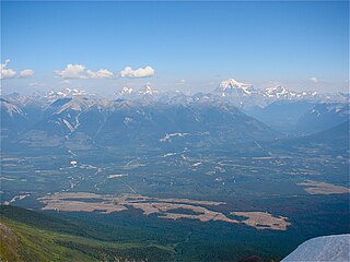
The Robson Valley is a geographic region of the Canadian province of British Columbia, comprising the section of the Rocky Mountain Trench that lies southeast of the city of Prince George following the Fraser River to the Yellowhead Pass. The name is derived from Mount Robson, which stands near the entrance to the Yellowhead Pass. Communities in the Robson Valley include the settlements of Dome Creek, Crescent Spur, Dunster, and Tête Jaune Cache, with larger population concentrations in the villages of McBride and Valemount. On a map, the Robson Valley is located immediately south of the elbow in the boundary between Alberta and British Columbia. Transportation corridors through the Robson Valley include the Canadian National Railway lines, and Highways 16 and 5.
Fountain is an unincorporated rural area and Indian reserve community in the Fraser Canyon region of British Columbia, Canada, located at the ten-mile (16 km) mark from the town of Lillooet on BC Highway 99, which in that area is also on the route of the Old Cariboo Road and is located at the junction of that route with the old gold rush-era trail via Fountain Valley and the Fountain Lakes.
The Holmes River is a tributary of the upper Fraser River in the Robson Valley region of British Columbia, Canada, entering that river southeast of the village of McBride. The river was named after Albert W. Holmes, provincial forest ranger at McBride. "Beaver River" is or was the local name, probably referring to a distinctive rock formation.

The Murtle River is a river in east-central British Columbia, Canada. It rises from a large unnamed glacier in the Cariboo Mountains at an elevation of 2,300 metres (7,500 ft) and flows southwest for 18 kilometres (11 mi) to the head of gigantic Murtle Lake. The river also drains Murtle Lake then flows southwest for 36 kilometres (22 mi) into the Clearwater River. The Murtle River is the longest and largest tributary to the Clearwater.

The Mount Edziza volcanic complex is a group of volcanoes and associated lava flows in northwestern British Columbia, Canada. Located on the Tahltan Highland, it is 40 kilometres southeast of Telegraph Creek and 85 kilometres southwest of Dease Lake. The complex encompasses a broad, steep-sided lava plateau that extends over 1,000 square kilometres. Its highest summit is 2,786 metres in elevation, making the MEVC the highest of four large complexes in an extensive north–south trending volcanic region. It is obscured by an ice cap characterized by several outlet glaciers that stretch out to lower altitudes.

Adams River is a tributary to the Thompson and Fraser Rivers in British Columbia, Canada. Beginning in the Monashee Mountains to the north, the Upper Adams River flows mainly southward and eventually reaches Adams Lake. The Lower Adams River begins at the southern end of the lake and flows into the extreme western end of Shuswap Lake. The river is one of the most important sockeye salmon breeding areas in North America. The run occurs in mid-October and can bring millions of fish to a concentrated area near the river mouth. Excavations of Secwepemc villages on the river have shown a long tradition of habitation and salmon fishing in the area. The river also served as an important transportation route for early logging operations in the watershed.
Kakwa Pass, 1,570 metres (5,151 ft), is a mountain pass in the Canadian Rockies. It is located in the province of British Columbia on the Continental Divide. It is located just east of McGregor Pass and to the north of the town of McBride.

Wells Gray Provincial Park is a large wilderness park located in east-central British Columbia, Canada. The park protects most of the southern, and highest, regions of the Cariboo Mountains and covers 5,415 square kilometres. It is British Columbia's fifth largest provincial park, after Tweedsmuir, Tatshenshini, Spatsizi and Northern Rocky Mountains.

Jumbo Glacier, also known as Jumbo, was a mountain resort municipality within the Regional District of East Kootenay in southeast British Columbia, Canada between 2013 and 2021. It was approximately 55 km (34 mi) west of Invermere near the Commander Glacier and around the headwaters of Jumbo Creek in the Purcell Range of the Columbia Mountains.

The Raush River is a tributary of the Fraser River in British Columbia, Canada. It drains a watershed of approximately 100,000 hectares on the eastern flanks of the Cariboo Mountains, a sub-range of the Columbia Mountains. The river joins the Fraser near the community of Dunster in the Robson Valley. The river's name is the result of a transcription error; it was originally called the Rivière au Shuswap, this was recorded on some maps as R.auSh., which then became Raush on official maps. Its source is the Raush Glacier, and major tributary creeks include Black Martin and Quanstrom.
The Goat River is a tributary of the Fraser River in British Columbia, Canada. Starting in the northern reaches of the Cariboo Mountains, it flows eastward and northeastward to join the Fraser near the settlement of Crescent Spur in the Robson Valley. Including its main tributary, the Milk River, its watershed covers 66,468 hectares. Other major tributaries for the river include McLeod, North Star, Whitehorse, Quartz, Diggings and Kendall creeks.

Kiwa Creek is a tributary of the Fraser River that extends from its source at Kiwa Glacier in the Cariboo Mountains to its confluence with the Fraser near Tête Jaune Cache, British Columbia. It is named from the Secwepemc word for "crooked".
