
Dule trees, or dool trees, in Britain were used as gallows for public hangings. They were also used as gibbets for the display of the corpse for a considerable period after such hangings. These "trees of lamentation or grief" were usually growing in prominent positions or at busy thoroughfares, particularly at crossroads, so that justice could be seen to have been done and as a salutary warning to others. Place names such as Gallows-Hill, Gallows-See, Gallows-Fey and Hill of the Gallows record the site of such places of execution.
A moot hill or mons placiti is a hill or mound historically used as an assembly or meeting place, as a moot hall is a meeting or assembly building, also traditionally to decide local issues. In early medieval Britain, such hills were used for "moots", meetings of local people to settle local business. Among other things, proclamations might be read; decisions might be taken; court cases might be settled at a moot. Although some moot hills were naturally occurring features or had been created long before as burial mounds, others were purpose-built.
Riccarton is a village and parish in East Ayrshire, Scotland. It lies across the River Irvine from Kilmarnock, this river forming the boundary between Riccarton and Kilmarnock parishes, and also between the historical districts of Kyle and Cunningham. The name is a corruption of 'Richard's town', traditionally said to refer to Richard Wallace, the uncle of Sir William Wallace. The parish also contains the village of Hurlford.
Craigie Castle, in the old Barony of Craigie, is a ruined fortification situated about 4 miles (6.4 km) southeast of Kilmarnock and 1 mile (1.6 km) southeast of Craigie village, in the Civil Parish of Craigie, South Ayrshire, Scotland. The castle is recognised as one of the earliest buildings in the county. It lies about 1.25 miles (2 km) west-south-west of Craigie church. Craigie Castle is protected as a scheduled monument.

Polnoon Castle was a 14th-century fortification located on a motte beside the Polnoon Water in Millhall, in the Parish of Eaglesham, East Renfrewshire, Scotland.
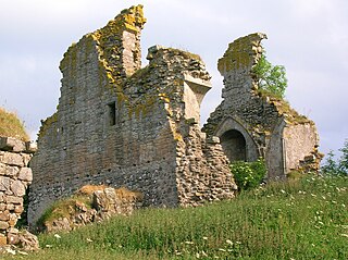
Trabboch Castle is a ruined L-plan tower house in the old Barony of Trabboch, Parish of Stair, East Ayrshire, Scotland.
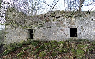
Haining Place or The Haining in the Parish of Kilmarnock lies near an old fording place across the Cessnock Water in East Ayrshire, Parish of Riccarton, Scotland. Hanyng (sic) was the caput or laird's dwelling of the Barony of Haining-Ross with a tower house or keep located in a defensive position on a high promontory of land, half encircled by the river. Later Haining Place may have been a dower house, then a tenanted farm, finally being used as farm workers accommodation. Haining Place is now a ruin following a fire. The old farm of Haining Mains is still located nearby.
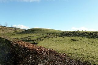
The Castle Knowe (NS20365081), is a prominent mound located slightly to the west of North Kilruskin Farm on the Kilruskin Toll Road, West Kilbride, North Ayrshire. Scotland. The mound may have served several different functions over the ages.

The Scheduled Ancient Monument of Alloway Mote, also known as the Alloway Moat or Alloway Motte, is a roughly circular earthwork that is regarded as a possible early medieval ringwork, located near the village of Alloway in South Ayrshire, Scotland.

Earlston is a hamlet in Riccarton, East Ayrshire, Scotland. The habitation dates from at least the early 18th century and is near Caprington Castle and Todrigs Mill. It was for many years the site of a large sawmill and a mine pumping engine, and had sidings of the Glasgow and South-Western Railway's Fairlie Branch.
What now survives of the old Caprington Loch (NS402352) is situated near Earlston, Riccarton, East Ayrshire, Scotland. The loch was a natural feature, sitting in a hollow on the old Caprington Castle estate. The loch waters drain via the Todrigs Burn that flows into the River Irvine to the east of Gatehead village. It was partly drained, probably sometime after the 1820s, as were so many other lochs, as part of 18th and 19th centuries extensive agricultural improvements and the only area of open water that remains does so as it was once used as a curling pond for the Caprington Castle Estate owners and their employees or tenants.

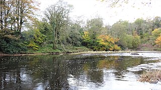
The Bickering bush (NS41863635) thorn grew near Caprington on the lands of Monksholm or Maxholm, Riccarton, East Ayrshire, Scotland. The old farm house at Maxholm sat in hollow on the old Caprington Castle estate and to the north and west its fields bordered the River Irvine. The thorn was located, as recorded on the OS map, near to the confluence of the Kilmarnock Water and the River Irvine, downstream of the Simon's Burn's confluence on the south bank of the river.
Craigie is a small village and parish of 6,579 acres in the old district of Kyle, now South Ayrshire, four miles south of Kilmarnock, Scotland. This is mainly a farming district, lacking in woodland, with a low population density, and only one village. In the 19th century, high quality lime was quarried here with at least three sites in use in 1832.

Lendalfoot is a small village located on Carleton Bay, parish of Colmonell in the old district of Carrick, now South Ayrshire, about six miles south of Girvan, Scotland. This is mainly a farming district, lacking in woodland, with a low population density. The village sits astride the A77 that runs north to Girvan and south to Cairnryan and Stranraer. Carleton Hill rises to 520 feet or 158 metres from the road and is the site near its summit of earth banks, an ancient fort.

The ruins of the five storey high 15th century Carleton Castle lie in a prominent position above the village of Lendalfoot located on Carleton Bay, parish of Colmonell in the old district of Carrick, now South Ayrshire, about 6 miles south of Girvan, Scotland.
The castle known as Gadgirth Old Ha' or Gadgirth Old Hall, was the first castle at Gadgirth, held by the Chalmer family, standing on a whinstone promontory overlooking the River Ayr in the Parish of Coylton, the old district of Kyle, now part of South Ayrshire, Scotland.
The Castle and Barony of Gadgirth was held by the Chalmer family, originally De Camera, with successive castles and a mansion house overlooking the River Ayr at the border of the Parish of Coylton, the old district of Kyle, now part of South Ayrshire, Scotland.

Lawthorn is a hamlet near Perceton in Strathannick, Irvine, North Ayrshire, Scotland. The settlement lies on the old Irvine to Stewarton toll road.

Kemp Law Dun is a vitrified fort dating from the Iron Age situated near the town of Dundonald in South Ayrshire, Scotland. The remains of the Iron Age fort or dun lie on the old Auchans Estate in the Dundonald Woods near the site of the old Hallyards Farm and the quarry of that name. The footpath route known as the Smugglers' Trail through the Clavin Hills from Troon to Dundonald runs passed the ruins of the dun. Kemps Law is in the order of two thousand years old.


