The Aan River is a short river in the South Island of New Zealand.
Lake Christabel is a small lake in the north of New Zealand's South Island. It is located 12 kilometres southwest of the Lewis Pass. The lake is the source of the Grey River, one of the longest rivers on the South Island's West Coast, although its outlet is underground. The lake lies behind a landslide dam, thought to have been created by a prehistoric earthquake. The river runs under the debris for about 200 m (660 ft). A 1976 survey said it was, "one of the very few lakes in New Zealand in a natural, unmodified state". It estimated its depth at over 90 m (300 ft). Galaxias brevipinnis and Anquilla dieffenbachii were the only fish found.
Abel Lake was a small lake in the Westland region of the South Island of New Zealand. It was located in the Southern Alps, 35 kilometres (22 mi) east of Franz Josef and was fed by the Abel Glacier. A short stream linked the lake with the Perth River. The lake was was likely displaced with alluvial / glacial rock or the outlet was lowered by natural erosion or manually by gold prospectors.

Ōhinetamatea River / Saltwater Creek is a river in the Westland District of New Zealand.
The Maraehara River is a river of the Gisborne Region in New Zealand. Rising on the eastern slopes of Mount Whakatiki in the Ruatoria Forest, the river flows eastwards. It flows into the Pacific Ocean, sharing a coastal lagoon with the larger Waiapu River.
The Little Grey River, also known as the Māwheraiti is a river of the West Coast Region of New Zealand. It is a major tributary of the Grey River / Māwheranui which it joins at Ikamatua.
Mount Franklin is a peak in the Nelson Lakes National Park in the Tasman Region of New Zealand. It is the northernmost – and highest – of New Zealand's four Mounts Franklin, located 15 kilometres (9.3 mi) south of Lake Rotoroa. It is the highest peak in the Tasman Region, just two metres higher than the nearby Mount Travers.
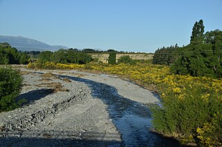
The Rainy River is a short river of the northeastern Marlborough Region of New Zealand's South Island. The 790-metre Rainy flows north from the Richmond Range into the Pelorus River, which it reaches five kilometres west of Pelorus Bridge.
The Spey River is a river in the Southland Region of New Zealand. Its entire length lies within the Fiordland National Park. The Spey rises at the Mckenzie Pass and Murrell's Pass either side of Mt Horatio (1,380 metres, and the river flows in a northeasterly direction, emptying into the West Arm of Lake Manapouri adjacent to the intake of the Manapouri Power Station. The Dusky Track follows the Spey valley for much of the river's length.
The Spey River is a river in the Tasman Mountains in the northwest of the South Island of New Zealand. The river drains Lake Aorere near the Aorere Saddle, and is fed by numerous small streams draining the Gouland Range on the west and part of the Domett Range on the east. It flows north then east before joining the upper reaches of the Aorere River.
The Snow River is a river in the Tasman Region of the South Island of New Zealand. It rises at the western end of the Haupiri Range and flows northward before rounding the tip of Kill Devil Spur to join the Slate River. The Slate is a tributary of the Aorere, the major river of the northwestern Tasman region.
The Cass River is an alpine river in the Canterbury region of the South Island of New Zealand. It rises in the Hall Range immediately below Rankin Pass, and also receives water from the nearby Huxley Glacier. After dropping 600 metres (2,000 ft) very rapidly the river flows south with braided channels along a flat-bottomed valley for 25 kilometres (16 mi). The Leibig Range and Gamack Range are to the west, and the Haszard Range to the east. The river flows into the west side of Lake Tekapo where it has built up a gravel delta.
The Fork River is a short river in the far south of the West Coast Region in New Zealand. As the name suggests, the river has two branches, with the longer South branch draining a plateau. The larger Spoon River lies a couple of kilometres to the north.
The Robinson River is a river in the West Coast Region of the South Island of New Zealand. It is a tributary of the Upper Grey River and much of the river lies within the Lake Sumner Conservation Park. Rising on the slopes of Mount Boscawen on the main divide about 12 kilometres (7.5 mi) south of the Lewis Pass, the river runs west-southwest along a straight, narrow valley before turning northwest to reach the Upper Grey.

The Ashburton River / Hakatere is a river in the Canterbury region of New Zealand, flowing across Mid Canterbury from the Southern Alps to the Pacific Ocean. The official name of the river was amended to become a dual name by the Ngāi Tahu Claims Settlement Act 1998. It has been identified as an Important Bird Area by BirdLife International because it supports breeding colonies of the endangered black-billed gull.
The northern Tiraumea River is a river of the Manawatū-Whanganui region of New Zealand's North Island. The river rises in the rough hill country of the Tararua District, just south of the settlement of Tiraumea. A tributary, Tiraumea Stream, drains the southern end of the Puketoi Range. The river flows west then north to reach the Manawatu River immediately above the highway and Rail bridges, 5 kilometres (3 mi) south of Woodville.
Mount Murchison is a mountain in the Southern Alps in the Canterbury region of New Zealand. It is the highest point of the Shaler Range, which runs approximately north–south to the east of the Wilberforce River. A col to the east of the peak separates two glaciers, the Kahutea Glacier to the south and the White Glacier to the Northeast.
The Tōtara River is a river of the southern West Coast of New Zealand's South Island. Rising on the slopes of Bald Hill the river flows north then west to reach the Tasman Sea two kilometres north of Ross.
The Kowai River is a river in the Canterbury region of New Zealand. It rises on the southern flanks of the Torlesse Range and travels south, emerging from the foothills of the Southern Alps near Springfield. The river turns east across the upper Canterbury Plains before joining the Waimakariri River. State Highway 73 follows the river as it climbs towards Porters Pass.
The Waikare River is a river in the Bay of Plenty Region of New Zealand' North Island. It flows north from its origins between the peaks of Matawhio and Papakai north of Lake Waikaremoana to reach the Whakatāne River 25 kilometres (16 mi) east of Murupara.
