Castlemilk House

Last updated

Castlemilk House, 1870 CastlemilkHouse.jpg
Castlemilk House, 1870

Castlemilk House was a country house located in what is now the Castlemilk district of Glasgow, Scotland. The house was the ancestral home of the Stirling-Stuart family and was built around the 15th-century Cassiltoun Tower during the 18th and 19th centuries. The house and Castlemilk Estate were purchased by Glasgow Corporation in 1938, with the house serving as a children's home until it was closed in 1969 and demolished in 1972.

Contents

History

Sketch of Castlemilk published in 1793 Castlemilk House 1790s.jpg
Sketch of Castlemilk published in 1793

The lands of Cassiltoun of Carmunnock, [1] located on high ground south of Glasgow between the hills of the Cathkin Braes and the burgh of Rutherglen near the River Clyde, were acquired by the Stuarts of Castlemilk in Dumfriesshire (an estate near Lockerbie which still exists also featuring a grand mansion) [2] [3] [4] [5] in the 13th century. In the 16th century, they renamed the Cassiltoun estate Castlemilk. [6] [7] [8] [9] Five generations of the Stuart family formed a dynastic baronetcy from the 1660s to the 1790s. [6] [10]

Ruins of Castlemilk House, 2008 The ruins of Castlemilk House - geograph.org.uk - 717417.jpg
Ruins of Castlemilk House, 2008
Fish pond in the park, adjacent to the location of the house The Pond - geograph.org.uk - 717406.jpg
Fish pond in the park, adjacent to the location of the house

In 1937 the 445 hectare (1100 acre) Estate of Castlemilk were acquired by Glasgow Corporation for housing. [11] The estate was acquired under a compulsory purchase order as William Stirling-Stuart, the Laird of Castlemilk, had misgivings over the land being used for high-density housing so far from locations of industry. [12] The outbreak of the Second World War delayed building work on the Castlemilk housing scheme, which was constructed in the 1950s, and soon modern tenements surrounded the house's grounds on all sides. [11]

Castlemilk House was acquired by Glasgow Corporation in 1939, and was used to accommodate evacuees from the city until the end of the war. It was then used as a children's home from 1948 until the expense of maintaining the house forced it to close in January 1969. Castlemilk House was demolished in 1972; [7] [8] [6] [13] [14] [15] a children's play area now occupies the site. [16] In the 21st century the many green areas between the clusters of housing, including the remaining features of the rural estate, are managed as Castlemilk Park and Woodlands, an award-winning project aimed to benefit the community. [17] [18]

Castlemilk Stables

Restored stable block Castlemilk Stables - geograph.org.uk - 717337.jpg
Restored stable block

Other than a small park featuring the landscaped fish pond and a stone bridge (1833, Category B listed) [6] which once formed the driveway to the mansion, and the entrance gateways which are sited to the north-east on the edge of Rutherglen, [19] the accompanying stables block (built 1794, designed by David Hamilton, also Category B listed) is the main surviving legacy of the grand estate. [14] After being damaged by a fire in 1994 [20] and left abandoned, [9] it was restored in 2007 (with the project winning awards) [21] and now contains the local housing offices, community facilities and a nursery. [22] [23]

See also

Related Research Articles

<span class="mw-page-title-main">Rutherglen</span> Town in Scotland

Rutherglen is a town in South Lanarkshire, Scotland, immediately south-east of the city of Glasgow, three miles from its centre and directly south of the River Clyde. Having previously existed as a separate Lanarkshire burgh, in 1975 Rutherglen lost its own local council and administratively became a component of the City of Glasgow District within the Strathclyde region. In 1996 the towns were reallocated to the South Lanarkshire council area.

<span class="mw-page-title-main">East Kilbride</span> Town in South Lanarkshire, Scotland

East Kilbride is the largest town in South Lanarkshire in Scotland, and the country's sixth-largest locality by population. It was also designated Scotland's first new town on 6 May 1947. The area lies on a raised plateau to the south of the Cathkin Braes, about eight miles southeast of Glasgow and close to the boundary with East Renfrewshire.

<span class="mw-page-title-main">Castlemilk</span> Human settlement in Scotland

Castlemilk is a district of Glasgow, Scotland. It lies to the far south of the city centre, adjacent to the Croftfoot and Simshill residential areas within the city to the north-west, the town of Rutherglen - neighbourhoods of Spittal to the north-east and Fernhill to the east, Linn Park and its golf course to the west, and the separate village of Carmunnock further south across countryside.

<span class="mw-page-title-main">Carmunnock</span> Human settlement in Scotland

Carmunnock is a conservation village situated within the Glasgow City council area, lying within three miles of East Kilbride and Rutherglen in South Lanarkshire and Busby in East Renfrewshire. The nearest other district within Glasgow is Castlemilk.

<span class="mw-page-title-main">Toryglen</span> Human settlement in Scotland

Toryglen is a district in southern Glasgow, Scotland, falling within the Langside ward under Glasgow City Council. It is approximately two miles south of the city centre, bounded to the west by Mount Florida, the north-west by Polmadie, to the north-east by the West Coast Main Line railway and the M74 motorway the south by King's Park, and immediately to the east by the town of Rutherglen.

<span class="mw-page-title-main">Croftfoot</span> Human settlement in Scotland

Croftfoot is a residential area on the southeastern side of the Scottish city of Glasgow. It is bordered by Castlemilk to the south and King's Park to the west within Glasgow, and by the Rutherglen areas of Spittal to the east and Bankhead to the north. Historically within the civil parish of Cathcart in Renfrewshire, it is within the Linn ward of Glasgow City Council.

The city of Glasgow, Scotland, has many amenities for a wide range of cultural activities, from curling to opera and from football to art appreciation; it also has a large selection of museums that include those devoted to transport, religion, and modern art. In 2009 Glasgow was awarded the title UNESCO Creative City of Music in recognition of its vibrant live music scene and its distinguished heritage. Glasgow has three major universities, each involved in creative and literary arts, and the city has the largest public reference library in Europe in the form of the Mitchell Library. Scotland's largest newspapers and national television and radio companies are based in the city.

<span class="mw-page-title-main">Fernhill, South Lanarkshire</span> Human settlement in Scotland

Fernhill is a residential neighbourhood in the Scottish town of Rutherglen in South Lanarkshire; it is situated south of the River Clyde and borders the Rutherglen neighbourhoods of High Burnside to the north and Cathkin to the east, the Glasgow district of Castlemilk to the west, and the open lands of Fernbrae Meadows to the south. Its location on a steep incline which is part of the Cathkin Braes range of hills offers panoramic views over the south and eastern parts of Greater Glasgow.

<span class="mw-page-title-main">King's Park, Glasgow</span> Human settlement in Scotland

King's Park is a district in the city of Glasgow, Scotland. It is situated south of the River Clyde and borders the Glasgow areas of Croftfoot, Cathcart, Simshill, Mount Florida and Toryglen and the neighbourhood of Bankhead in the adjoining town of Rutherglen.

<span class="mw-page-title-main">Burnside, South Lanarkshire</span> Human settlement in Scotland

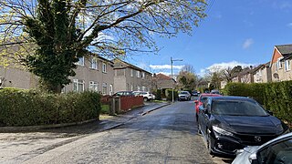
Burnside is a mostly residential area in the town of Rutherglen in South Lanarkshire, Scotland. Including the neighbourhoods of High Burnside and High Crosshill, respectively south and north-west of its main street, it borders Overtoun Park in Rutherglen plus several other residential areas of the town, as well as western parts of neighbouring Cambuslang.

<span class="mw-page-title-main">Stonelaw High School</span> Secondary school in Rutherglen, South Lanarkshire, Scotland

Stonelaw High School is a non-denominational state high school located in Rutherglen, Scotland near the city of Glasgow.

<span class="mw-page-title-main">A730 road</span> Road in Scotland running from the centre of Glasgow to Cathkin

The A730 road in Scotland runs between the centre of Glasgow and the south-eastern edge of the city's urban area at Cathkin.

<span class="mw-page-title-main">Cathcart Castle</span> Castle in Glasgow City, Scotland, UK

Cathcart Castle was a 15th-century castle, located in what is now Linn Park in the Cathcart area of southern Glasgow, Scotland. The castle was abandoned in the 18th century, and the remaining ruins were pulled down in 1980, leaving only foundations visible.

<span class="mw-page-title-main">Cathkin High School</span> Secondary school comprehensive school in Cambuslang, South Lanarkshire, Scotland

Cathkin High School is a state secondary school in Cambuslang, South Lanarkshire, Scotland.

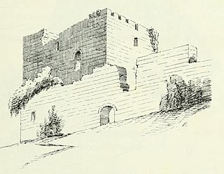
Farme Castle was located in Rutherglen, to the south-east of Glasgow, Scotland. It stood 0.5 miles (0.80 km) east of Farme Cross where the A724 meets the A749 trunk road. The castle keep acted as one corner of a courtyard, formed by an extension in the form of a castellated mansion. High walls and subsidiary buildings completed the courtyard. There was an ornate arched gateway to the courtyard adjacent to the keep. The old keep was of three storeys and a garret, above a corbelled-out parapet with machicolations and water spouts.

<span class="mw-page-title-main">Linn Park, Glasgow</span> 200 acre park in Glasgow, Scotland

Linn Park is an 82-hectare (200-acre) park in Glasgow, Scotland, surrounded by the suburbs of Cathcart, Muirend, Simshill, and Castlemilk, also bordering Netherlee in East Renfrewshire. It is Glasgow's third largest park, after Pollok Country Park and Dams to Darnley Country Park, although Dams to Darnley is half in East Renfrewshire. Both Linn and Pollok parks have the White Cart Water flowing through them. Some areas in the park are unsuitable for prams and the infirm.

<span class="mw-page-title-main">A749 road</span> Road in Scotland

The A749 road in Scotland connects East Kilbride with Glasgow city centre via Rutherglen and Bridgeton.

<span class="mw-page-title-main">Cathkin Braes</span>

Cathkin Braes is an area of hills to the south east of the city of Glasgow, in Scotland. It lies to the south of the districts of Castlemilk, Fernhill and Burnside, and to the east of Carmunnock.

<span class="mw-page-title-main">Calderglen Country Park</span> Country park in South Lanarkshire, Scotland, UK

Calderglen Country Park is a country park in the town of East Kilbride, South Lanarkshire, Scotland. It is situated along the eastern edge of the town and is its principal greenspace and recreation area.

<span class="mw-page-title-main">Whitlawburn</span> Human settlement in Scotland

Whitlawburn is a residential area in the town of Cambuslang in South Lanarkshire, Scotland. It is located south of the town centre on high ground overlooking the Greater Glasgow urban area.

References

  1. Map of the Parish of Carmunnock in the Historical County of Lanark, Gazetteer for Scotland
  2. Castlemilk [Dumfriesshire], Canmore
  3. Castlemilk [Dumfriesshire], Gazetteer for Scotland
  4. Castlemilk, Annandale, British Listed Buildings
  5. Castle Milk, Lockerbie, Dumfriesshire, Scotland, Children's Homes Website
  6. 1 2 3 4 "Castlemilk, Glasgow - origins & history". Glasgow's South Side. Archived from the original on 4 February 2020. Retrieved 13 February 2018.
  7. 1 2 "Castlemilk House (Glasgow University Library, Special Collections, Dougan Collection, 1870)". The Glasgow Story. Retrieved 13 February 2018.
  8. 1 2 "Castlemilk House (Mitchell Library, Glasgow Collection, Postcards Collection, 1904)". The Glasgow Story. Retrieved 13 February 2018.
  9. 1 2 History, Cassiltoun Trust
  10. Of the Extent of Kilbride, its Population, Places of Note, &c., Part II., pp.151-161., History of Rutherglen and East-Kilbride, David Ure, 1793, via Random Scottish History
  11. 1 2 Castlemilk from Cathkin Braes (Glasgow City Archives, Department of Architectural and Civic Design, 1957), The Glasgow Story
  12. "Housing, Everyday Life & Wellbeing over the long term: A brief history of Castlemilk housing estate". University of Glasgow . Retrieved 13 February 2018.
  13. "Castlemilk from Cathkin Braes". The Glasgow Story. Retrieved 13 February 2018.
  14. 1 2 Stable place to be, Evening Times, 12 September 2008
  15. Dark and mysterious Castlemilk House, Glasgow, Spooky Isles, 3 November 2014
  16. Castlemilk Castle (Lanarkshire) - Past & Present, Scottish Castles Association, 19 January 2012
  17. Castlemilk Park Project, Cassiltoun Housing Association
  18. Cassiltoun Housing Association wins prize for their work at Castlemilk Woods, Scottish Federation of Housing Associations, 18 August 2016
  19. Croftfoot Road, Mill Street, Gatepiers, Formerly to Castlemilk House, British Listed Buildings
  20. "Castlemilk House stables (West of Scotland Archaeology Service)". The Glasgow Story. Retrieved 13 February 2018.
  21. "MyPlace Awards: Castlemilk Stables". Scottish Civic Trust. Archived from the original on 13 February 2018. Retrieved 13 February 2018.
  22. "Case study: Castlemilk Stables, Glasgow". The Prince's Regeneration Trust. Archived from the original on 26 October 2017. Retrieved 13 February 2018.
  23. "Castlemilk Stables". Glasgow Building Preservation Trust. 10 June 2016. Archived from the original on 13 February 2018. Retrieved 13 February 2018.

55°48′32″N4°13′12″W / 55.809°N 4.220°W / 55.809; -4.220