Castlereagh West (District Electoral Area)

Last updated
Castlereagh West DEA (1993-2014) within Castlereagh Castlereagh 1993 Castlereagh West highlight.svg
Castlereagh West DEA (1993-2014) within Castlereagh

Castlereagh West was one of the four district electoral areas in Castlereagh, Northern Ireland which existed from 1993 to 2014. The district elected five members to Castlereagh Borough Council, and formed part of Belfast South constituencies for the Northern Ireland Assembly and UK Parliament.

Contents

It was created for the 1993 local elections, and contained the wards of Beechill, Galwally, Hillfoot, Minnowburn and Newtownbreda. It was abolished for the 2014 local elections and mostly transferred to the Castlereagh South DEA with Hillfoot moved to form part of the new Lisnasharragh DEA for the 2014 Belfast City Council election.

Councillors

ElectionCouncillor
(Party)
Councillor
(Party)
Councillor
(Party)
Councillor
(Party)
Councillor
(Party)
2011 Sara Duncan
(Alliance)
Peter O'Reilly
(SDLP)
Cecil Hall
(UUP)
Ann-Marie Beattie
(DUP)
Myreve Chambers
(DUP)
2005 Rosaleen Hughes
(SDLP)
2001 Mark Robinson
(DUP)
Vivienne Stevenson
(DUP)
1997 William Clulow
(DUP)
1993 David Andrews
(Alliance)
John Taylor
(UUP)
William Stevenson
(UUP)
Ernest Harper
(DUP)

2011 Election

2005: 2 x DUP, 1 x Alliance, 1 x SDLP, 1 x UUP

2011: 2 x DUP, 1 x Alliance, 1 x SDLP, 1 x UUP

2005-2011 Change: No change

Castlereagh West - 5 seats [1]
PartyCandidateFPv%Count
12345
Alliance Sara Duncan*26.97%1,456    
DUP Ann-Marie Beattie*21.08%1,138    
SDLP Peter O'Reilly17.34%936    
DUP Myreve Chambers*11.67%630726 948.6  
UUP Cecil Hall*11.13%601768.5 777.11 811.61 850.67
UUP Bill White4.98%269370.5 374.07 397.78 405.22
Sinn Féin Laura Keenan5.11%276340 340.21 386.71 387.13
People Before Profit Gordon Hewitt1.72%93215 215.21   
Electorate: 10,045  Valid: 5,399 (53.75%)  Spoilt: 100  Quota: 900  Turnout: 5,499 (54.74%)  

    2005 Election

    2001: 2 x DUP, 1 x Alliance, 1 x SDLP, 1 x UUP

    2005: 2 x DUP, 1 x Alliance, 1 x SDLP, 1 x UUP

    2001-2005 Change: No change

    Castlereagh West - 5 seats [2]
    PartyCandidateFPv%Count
    123456
    DUP Ann-Marie Beattie24.00%1,417     
    Alliance Sara Duncan*19.93%1,177     
    DUP Myreve Chambers10.09%596991.1    
    UUP Cecil Hall*14.14%835847.6 917.3 1,039.3  
    SDLP Rosaleen Hughes*13.45%794794.6 850.53 862.85 862.85 1,285.85
    UUP Bill White6.42%379384.1 410.28 467.14 519.08 525.08
    SDLP Gary Vaugh7.47%441441 458 467.19 468.78  
    Independent Cyril Kernaghan4.50%266271.4 284.66    
    Electorate: 9,805  Valid: 5,905 (60.22%)  Spoilt: 145  Quota: 985  Turnout: 6,050 (61.70%)  

      2001 Election

      1997: 2 x DUP, 1 x UUP, 1 x SDLP, 1 x Alliance

      2001: 2 x DUP, 1 x UUP, 1 x SDLP, 1 x Alliance

      1997-2001 Change: No change

      Castlereagh West - 5 seats [3]
      PartyCandidateFPv%Count
      123456
      DUP Mark Robinson 27.20%1,858     
      UUP Cecil Hall*25.30%1,728     
      SDLP Rosaleen Hughes*17.51%1,196     
      Alliance Sara Duncan*16.54%1,1301,141.31    
      DUP Vivienne Stevenson0.89%61603.88 840.76 841.6 1,075.37 1,276.18
      NI Women's Coalition Eileen Cairnduff4.48%306311.85 463.47 570.89 577.96 672.08
      PUP Frederick Ferguson4.41%301324.01 452.53 459.53 469  
      DUP Charles Tosh1.35%92223.82 280.52 280.94   
      Sinn Féin Sean Montgomery2.31%158158 162.62    
      Electorate: 10,958  Valid: 6,830 (62.33%)  Spoilt: 164  Quota: 1,139  Turnout: 6,994 (63.83%)  

        1997 Election

        1993: 2 x UUP, 2 x DUP, 1 x Alliance

        1997: 2 x DUP, 1 x UUP, 1 x Alliance, 1 x SDLP

        1993-1997 Change: SDLP gain from UUP

        Castlereagh West - 5 seats [4]
        PartyCandidateFPv%Count
        123456789
        DUP William Clulow*19.80%952        
        Alliance Sara Duncan14.49%697700.45 816.45      
        DUP Mark Robinson 12.62%607698.5 701.5 815.5     
        UUP Cecil Hall15.47%744759.15 763.3 777.85 781.3 788.5 1,024.5  
        SDLP Rosaleen Hughes*12.87%619619.3 625.3 626.45 631.85 631.85 631.85 637.85 659.6
        PUP Samuel Johnston7.63%367371.8 373.8 378.15 380.4 382 404.9 448.9 651.25
        Ind. Unionist Ernest Harper*5.55%267279.6 281.75 289.15 291.55 294.15 313.5 418.5  
        UUP Marie Luney5.70%274276.25 277.25 284.3 285.2 287.2    
        DUP Thomas Scott2.95%142153.4 153.4       
        Alliance Malcolm Gilmore2.91%140140.3        
        Electorate: 11,140  Valid: 4,809 (43.17%)  Spoilt: 87  Quota: 802  Turnout: 4,896 (43.95%)  

          1993 Election

          1993: 2 x UUP, 2 x DUP, 1 x Alliance

          Castlereagh West - 5 seats [5]
          PartyCandidateFPv%Count
          123456
          UUP John Taylor *34.16%1,549     
          DUP Ernest Harper*21.81%989     
          Alliance David Andrews20.40%925     
          UUP William Stevenson3.75%170781    
          DUP William Clulow8.05%365434.16 493.68 496.2 518.84 796.44
          Alliance Sara Duncan5.25%238264 266.4 420.66 531.52 546.64
          DUP William Smyth2.95%89139.96 309.16 310.42 349.78  
          NI Conservatives Andrew Fee4.63%210232.36 232.84 237.34   
          Electorate: 10,557  Valid: 4,535 (42.96%)  Spoilt: 120  Quota: 756  Turnout: 4,655 (44.09%)  

            Related Research Articles

            <span class="mw-page-title-main">Balmoral (District Electoral Area)</span>

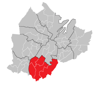
            Balmoral is the most southern of ten district electoral areas (DEA) in Belfast, Northern Ireland. The district elects five members to Belfast City Council and contains the wards of Belvoir; Finaghy; Malone; Musgrave; Windsor; and Upper Malone. Balmoral, along with neighbouring Botanic, forms the greater part of the Belfast South constituencies for the Northern Ireland Assembly and UK Parliament.

            <span class="mw-page-title-main">Castle (District Electoral Area)</span> District Electoral Area in Belfast, Northern Ireland

            Castle is one of the ten district electoral areas in Belfast, Northern Ireland. Located in the north of the city, the district elects six members to Belfast City Council and contains the wards of Bellevue, Cavehill, Chichester Park, Duncairn, Fortwilliam and Innisfayle. Castle, along with Oldpark district and parts of the Court district and Newtownabbey Borough Council, forms the Belfast North constituency for the Northern Ireland Assembly and UK Parliament. The district is bounded to the east by the Victoria Channel, to the north by Newtownabbey Borough Council and Belfast Lough, to the south by North Street and to the west by the Cavehill Road.

            <span class="mw-page-title-main">Oldpark (District Electoral Area)</span> Electoral division in Belfast, Northern Ireland

            Oldpark is one of the ten district electoral areas (DEA) in Belfast, Northern Ireland. Located in the north of the city, the district elects six members to Belfast City Council and contains the wards of Ardoyne; Ballysillan; Cliftonville; Legoniel; New Lodge and Water Works. Oldpark forms part of the Belfast North constituency for the Northern Ireland Assembly and UK Parliament.

            <span class="mw-page-title-main">Pottinger (District Electoral Area)</span> Human settlement in Northern Ireland

            Pottinger was one of the nine district electoral areas (DEA) in Belfast, Northern Ireland from 1985 to 2014. Located in the east of the city, the district elected six members to Belfast City Council and contained the wards of Ballymacarrett, Bloomfield, Orangefield, Ravenhill, The Mount, and Woodstock.

            <span class="mw-page-title-main">Victoria (District Electoral Area)</span> Electoral division in east Belfast, Northern Ireland

            Victoria was one of the nine district electoral areas (DEA) in Belfast, Northern Ireland, from 1985 to 2014, when it was mostly replaced by the Ormiston district.

            <span class="mw-page-title-main">2011 Castlereagh Borough Council election</span> Local government election in Northern Ireland

            Elections to Castlereagh Borough Council were held on 5 May 2011 on the same day as the other Northern Irish local government elections. The election used four district electoral areas to elect a total of 23 councillors.

            <span class="mw-page-title-main">Ards Peninsula (District Electoral Area)</span> District electoral area in Ards and North Down, Northern Ireland

            Ards Peninsula is one of the seven district electoral areas (DEA) in Ards and North Down, Northern Ireland. The district elects five members to Ards and North Down Borough Council and contains the wards of Ballywalter, Carrowdore, Kircubbin, Loughries, Portaferry and Portavogie. Ards Peninsula forms part of the Strangford constituencies for the Northern Ireland Assembly and UK Parliament.

            <span class="mw-page-title-main">Castlereagh East (District Electoral Area)</span> Electoral area in Northern Ireland

            Castlereagh East is one of the seven district electoral areas (DEA) in Lisburn and Castlereagh, Northern Ireland. The district elects five members to Lisburn and Castlereagh City Council and contains the wards of Ballyhanwood, Carrowreagh, Dundonald, Enler, Graham's Bridge and Moneyreagh. Castlereagh East forms part of the Belfast East constituencies for the Northern Ireland Assembly and UK Parliament.

            <span class="mw-page-title-main">Castlereagh South (District Electoral Area)</span> Electoral area in Northern Ireland

            Castlereagh South is one of the seven district electoral areas (DEA) in Lisburn and Castlereagh, Northern Ireland. The district elects five members to Lisburn and Castlereagh City Council and contains the wards of Beechill, Cairnshill, Carryduff East, Carryduff West, Galwally, Knockbracken and Newtownbreda. Castlereagh South forms part of the Belfast South constituencies for the Northern Ireland Assembly and UK Parliament.

            <span class="mw-page-title-main">Castlereagh Central (District Electoral Area)</span> District electoral areas in Ards, Northern Ireland

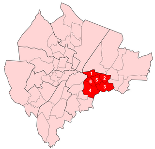
            Castlereagh Central was one of the district electoral areas in Castlereagh, Northern Ireland which existed from 1985 to 2014. It was one of three Castlereagh DEAs until 1993, and one of four until 2014. The district elected seven members to Castlereagh Borough Council from 1985 to 1993, and six members from 1993 to 2014. It formed part of the Strangford constituency until 1997, the Strangford and Belfast East constituencies from 1997 to 2010 and the Belfast East and Belfast South constituencies for the Northern Ireland Assembly and UK Parliament.

            <span class="mw-page-title-main">Lisburn North (District Electoral Area)</span> District electoral area in Northern Ireland

            Lisburn North is one of the seven district electoral areas (DEA) in Lisburn and Castlereagh, Northern Ireland. The district elects six members to Lisburn and Castlereagh City Council and contains the wards of Derryaghy, Harmony Hill, Hilden, Lambeg, Magheralave and Wallace Park. Lisburn North forms part of the Lagan Valley constituencies for the Northern Ireland Assembly and UK Parliament.

            <span class="mw-page-title-main">Killultagh (District Electoral Area)</span> District electoral area in Northern Ireland

            Killultagh is one of the seven district electoral areas (DEA) in Lisburn and Castlereagh, Northern Ireland. The district elects five members to Lisburn and Castlereagh City Council and contains the wards of Ballinderry, Glenavy, Maghaberry, Stonyford and White Mountain. Killultagh forms part of the Lagan Valley constituencies for the Northern Ireland Assembly and UK Parliament, and part of the South Antrim constituencies for the Northern Ireland Assembly and UK Parliament.

            Dunmurry Cross was one of the district electoral areas in Lisburn, Northern Ireland which existed from 1985 to 2014. It was one of four Lisburn DEAs until 1993, and one of five until 2014. The district elected seven members to Lisburn City Council and formed part of Belfast West constituencies for the Northern Ireland Assembly and UK Parliament and part of the Lagan Valley constituencies for the Northern Ireland Assembly and UK Parliament.

            Antrim Line was one of the district electoral areas in Newtownabbey, Northern Ireland which existed from 1985 to 2014, one of five DEAs until 1993 and one of four DEAs until 2014. The district elected five members to Newtownabbey Borough Council until 1993 and seven members until 2014, and formed part of the South Antrim constituencies for the Northern Ireland Assembly and UK Parliament and part of the Belfast North constituencies for the Northern Ireland Assembly and UK Parliament.

            <span class="mw-page-title-main">Antrim South East (District Electoral Area)</span> District electoral areas in Antrim, Northern Ireland

            Antrim South East was one of the three district electoral areas in Antrim, Northern Ireland which existed from 1985 to 2014. The district elected seven members to Antrim Borough Council and formed part of the South Antrim constituencies for the Northern Ireland Assembly and UK Parliament.

            <span class="mw-page-title-main">Coast Road (District Electoral Area)</span> District electoral area in Northern Ireland

            Coast Road is one of the seven district electoral areas (DEA) in Mid and East Antrim, Northern Ireland. The district elects five members to Mid and East Antrim District Council and contains the wards of Cairncastle, Carnlough and Glenarm, Craigyhill, Gardenmore and The Maidens. Coast Road forms part of the East Antrim constituencies for the Northern Ireland Assembly and UK Parliament.

            <span class="mw-page-title-main">The Skerries (District Electoral Area)</span> District electoral areas in Coleraine, Northern Ireland

            The Skerries was one of the district electoral areas in Coleraine, Northern Ireland which existed from 1985 to 2014, one of three DEAs from 1985 to 1993 and one of four DEAs from 1993 to 2014. The district elected seven members to Coleraine Borough Council until 1993, and five until 2014, and formed part of the East Londonderry constituencies for the Northern Ireland Assembly and UK Parliament.

            <span class="mw-page-title-main">Banbridge (District Electoral Area)</span> District electoral area in Northern Ireland

            Banbridge is one of the seven district electoral areas (DEA) in Armagh City, Banbridge and Craigavon, Northern Ireland. The district elects seven members to Armagh City, Banbridge and Craigavon Borough Council and contains the wards of Banbridge East, Banbridge North, Banbridge South, Banbridge West, Gilford, Loughbrickland and Rathfriland. Banbridge forms part of the Upper Bann constituencies for the Northern Ireland Assembly and UK Parliament.

            <span class="mw-page-title-main">Rowallane (District Electoral Area)</span> District electoral area in Northern Ireland

            Rowallane is one of the seven district electoral areas (DEA) in Newry, Mourne and Down, Northern Ireland. The district elects five members to Newry, Mourne and Down District Council and contains the wards of Ballynahinch, Crossgar and Killyleagh, Derryboy, Kilmore and Saintfield. Rowallane forms part of the Strangford constituencies for the Northern Ireland Assembly and UK Parliament and part of the South Down constituencies for the Northern Ireland Assembly and UK Parliament.

            Castlereagh Area C was one of the three district electoral areas in Castlereagh, Northern Ireland which existed from 1973 to 1985. The district elected five members to Castlereagh Borough Council, and formed part of the Belfast East constituencies for the Northern Ireland Assembly and UK Parliament.

            References

            1. "Castlereagh West Result Sheet" (PDF). EONI. Retrieved 8 July 2021.
            2. "Local Government Results 2005". EONI. Retrieved 8 July 2021.
            3. "Local Government Results 2001". EONI. Retrieved 8 July 2021.
            4. "Local Government Results 1997". EONI. Retrieved 8 July 2021.
            5. "Local Government Results 1993". EONI. Retrieved 8 July 2021.