
Alaska is a non-contiguous U.S. state on the northwest extremity of North America. It borders British Columbia and Yukon in Canada to the east and it shares a western maritime border in the Bering Strait with Russia's Chukotka Autonomous Okrug. The Chukchi and Beaufort Seas of the Arctic Ocean lie to the north and the Pacific Ocean lies to the south. Technically a semi-exclave of the U.S., Alaska is the largest exclave in the world.

The Bureau of Land Management (BLM) is an agency within the United States Department of the Interior responsible for administering U.S. federal lands. Headquartered in Washington, D.C., the BLM oversees more than 247.3 million acres (1,001,000 km2) of land, or one-eighth of the United States's total landmass.

Hoonah–Angoon Census Area is a census area located in the U.S. state of Alaska. As of the 2020 census, the population was 2,365, up from 2,150 in 2010. It is part of the unorganized borough and therefore has no borough seat. Its largest community is the city of Hoonah.
Homer is a city in Kenai Peninsula Borough in the U.S. state of Alaska. It is 218 mi (351 km) southwest of Anchorage. According to the 2020 Census, the population is 5,522, up from 5,003 in 2010. Long known as the "Halibut Fishing Capital of the World", Homer is also nicknamed "the end of the road", and more recently, "the cosmic hamlet by the sea".

Glacier View is a census-designated place (CDP) in Matanuska-Susitna Borough, Alaska, United States. It is part of the Anchorage Metropolitan Area. At the 2020 census the population was 375, up from 234 in 2010. The terminus of Matanuska Glacier is located approximately three miles southwest of Glacier View.

Lake Louise is a census-designated place (CDP) in Matanuska-Susitna Borough, Alaska, United States. Although it is an isolated settlement and is close to Glennallen, it is considered part of the Anchorage Metropolitan Area, like all other locations in the Mat-Su Borough. At the 2020 census the population was 15, down from 46 in 2010 and 88 in 2000.

Palmer is a city in and the borough seat of the Matanuska-Susitna Borough, Alaska, United States, located 42 miles (68 km) northeast of Anchorage on the Glenn Highway in the Matanuska Valley. It is the ninth-largest city in Alaska, and forms part of the Anchorage Metropolitan Statistical Area. As of the 2020 census, the population of the city is 5,888, down from 5,937 in 2010.
Gustavus is a second-class city in Hoonah-Angoon Census Area in the U.S. state of Alaska. The 2020 census population was 655, which represents a 48% increase over the 2010 census of 442 and is one of the fastest growing communities in Alaska.

Valdez is a city in the Chugach Census Area in the U.S. state of Alaska. According to the 2020 US Census, the population of the city is 3,985, up from 3,976 in 2010. It is the third most populated city in Alaska's Unorganized Borough.
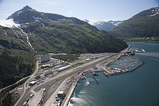
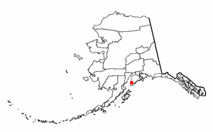
Whittier is a city at the head of the Passage Canal in the U.S. state of Alaska, about 58 miles (93 km) southeast of Anchorage. The city is within the Chugach Census Area, one of the two entities established in 2019 when the former Valdez–Cordova Census Area was dissolved. It is also a port for the Alaska Marine Highway. The population was 272 at the 2020 census, having increased from 220 in 2010.

The Alaska Range is a relatively narrow, 600-mile-long (950 km) mountain range in the southcentral region of the U.S. state of Alaska, from Lake Clark at its southwest end to the White River in Canada's Yukon Territory in the southeast. Denali, the highest mountain in North America, is in the Alaska Range. The range is part of the American Cordillera.

Denali Highway is a lightly traveled, mostly gravel highway in the U.S. state of Alaska. It leads from Paxson on the Richardson Highway to Cantwell on the Parks Highway. Opened in 1957, it was the first road access to Denali National Park. Since 1971, primary park access has been via the Parks Highway, which incorporated a section of the Denali Highway from Cantwell to the present-day park entrance. The Denali Highway is 135 miles (217 km) in length.

The National Petroleum Reserve in Alaska (NPRA) is an area of land on the Alaska North Slope owned by the United States federal government and managed by the Department of the Interior, Bureau of Land Management (BLM). It lies to the west of the Arctic National Wildlife Refuge, which, as a U.S. Fish and Wildlife Service managed National Wildlife Refuge, is also federal land.
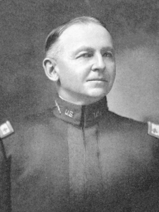
Joseph Compton Castner was a United States Army general. He commanded the Ninth Infantry Brigade in all its operations as a part of the Fifth Division, American Expeditionary Forces (AEF) during the final months of World War I.

Mount Castner is a 5,535-foot (1,687 m) elevation glaciated summit located 44 mi (71 km) west of Valdez in the Chugach Mountains of the U.S. state of Alaska, on land managed by Chugach National Forest. It is situated at the head of Ranney Glacier and Dartmouth Glacier. Although modest in elevation, relief is significant since the mountain rises from tidewater at Unakwik Inlet and College Fjord of Prince William Sound in approximately three miles. The mountain's name was applied in 1910 by Lawrence Martin, and officially adopted by the United States Geological Survey. This peak's name honors Joseph Compton Castner (1869–1946), who was with Captain Edwin F. Glenn during the exploration of this area in 1898.
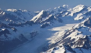
Mount Glenn is a 9,806-foot (2,989 m) elevation glaciated summit located 40 mi (64 km) northwest of Valdez in the Chugach Mountains of the U.S. state of Alaska. This remote mountain north of Prince William Sound, set on land managed by Chugach National Forest, is situated 6.44 mi (10 km) west-southwest of Mount Witherspoon, and 9.34 mi (15 km) west of Mount Einstein. It is part of the Dora Keen Range, which is a 25-miles-long divide separating Harvard Glacier from Yale Glacier. The mountain's name was applied in 1911 by Lawrence Martin, and officially adopted in 1930 by the U.S. Board on Geographic Names to honor Edwin Forbes Glenn (1857–1926), an Army officer who explored this College Fjord area in 1898. The Glenn Highway is also named for this same person.
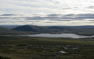
Toolik Lake is an Arctic lake located within the North Slope Borough, Alaska. It is in a remote wilderness area managed by the Bureau of Land Management accessed by the Dalton Highway. It is 130 mi (210 km) south of Prudhoe Bay in the northern foothills of the Brooks Range. The name is derived from the Iñupiat word tutlik, meaning yellow-billed loon.


