
Castor and Pollux are twin half-brothers in Greek and Roman mythology, known together as the Dioscuri or Dioskouroi.

Shackleton Glacier is a major Antarctic glacier, over 60 nautical miles long and from 5 to 10 nautical miles wide, descending from the Antarctic Plateau from the vicinity of Roberts Massif and flowing north through the Queen Maud Mountains to enter the Ross Ice Shelf between Mount Speed and Waldron Spurs. Discovered by the United States Antarctic Service (USAS) (1939–41) and named by the Advisory Committee on Antarctic Names (US-ACAN) for Sir Ernest Shackleton, British Antarctic explorer.

James Ross Island is a large island off the southeast side and near the northeastern extremity of the Antarctic Peninsula, from which it is separated by Prince Gustav Channel. Rising to 1,630 metres (5,350 ft), it is irregularly shaped and extends 40 nautical miles in a north–south direction.
Vega Island is an island in Antarctica, 17 nautical miles long and 6 nautical miles wide, which is the northernmost of the James Ross Island group and lies in the west part of Erebus and Terror Gulf. It is separated from James Ross Island by Herbert Sound and from Trinity Peninsula by Prince Gustav Channel.
Reclus Peninsula is a 7 nautical miles peninsula on the west coast of Graham Land, Antarctica. It borders Charlotte Bay to its east.

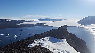
Convoy Range is a broad range in Antarctica. It is south of the Kirkwood Range and north of the Clare Range.

Ulu Peninsula is that portion of James Ross Island northwest of the narrow neck of land between Rohss Bay and Croft Bay, extending from Cape Obelisk to Cape Lachman, in Antarctica.
Avian Island is an island, 1.2 km (0.7 mi) long and 40 metres (130 ft) high, lying close off the south tip of Adelaide Island, Antarctica. It was discovered by the French Antarctic Expedition, 1908–10, under Jean-Baptiste Charcot, and visited in 1948 by the Falkland Islands Dependencies Survey, who so named it because of the large number and variety of birds (avians) found there.
The Tabarin Peninsula is a peninsula 15 nautical miles long and 5 to 12 nautical miles wide, lying south of the trough between Hope Bay and Duse Bay and forming the east extremity of Trinity Peninsula in the Antarctic Peninsula.

Gemini is one of the constellations of the zodiac and is located in the northern celestial hemisphere. It was one of the 48 constellations described by the 2nd century AD astronomer Ptolemy, and it remains one of the 88 modern constellations today. Its name is Latin for twins, and it is associated with the twins Castor and Pollux in Greek mythology. Its old astronomical symbol is (♊︎).
Buddha Rock is a rock, 35 metres (115 ft) high, lying 0.3 nautical miles (0.6 km) west of Vindication Island in the South Sandwich Islands. It was charted and named in 1930 by Discovery Investigations personnel on the RSS Discovery II.
Cugnot Ice Piedmont is an ice piedmont in Trinity Peninsula, Antarctica. It is about 15 nautical miles long and between 3 and 6 nautical miles wide, extending from Russell East Glacier to Eyrie Bay and bounded on the landward side by Louis Philippe Plateau.
Planet Heights is a series of summits running along an ice-free ridge, extending 24 nautical miles (44 km) in a north-south direction between the southernmost extremity of the LeMay Range and George VI Sound in the east part of Alexander Island, Antarctica. Many landforms and nearby features are named in association with this mountain range; some of these include landforms named after astronomers, satellites, planets and other things related to astrology and astrophysics. The mountain range was first mapped from air photos taken by the Ronne Antarctic Research Expedition (RARE), 1947–48, by Searle of the Falkland Islands Dependencies Survey (FIDS) in 1960. Named by the United Kingdom Antarctic Place-Names Committee (UK-APC) from association with the nearby glaciers named for planets of the Solar System. The only planet that is not featured in any of these glaciers is the planet Earth, as there are no glaciers named "Earth Glacier" and this glacier does not exist.
Pollux Nunatak is one of the Seal Nunataks, lying 2 nautical miles (3.7 km) northwest of Robertson Island in Larsen Ice Shelf. The probable existence of the feature was first reported by Falkland Islands Dependencies Survey (FIDS) in 1947 and its existence was confirmed during a FIDS survey in 1953. The United Kingdom Antarctic Place-Names Committee (UK-APC) name derives from its association with Castor Nunatak 4.5 nautical miles (8 km) to the SSW; Castor and Pollux were sons of Zeus.
Pollux Rock is the southern of a pair of large off-lying rocks south of Vindication Island, South Sandwich Islands. This rock, with its neighbour Castor Rock, was named "Castor and Pollux" during the survey of these islands from RRS Discovery II in 1930. In 1971 United Kingdom Antarctic Place-Names Committee (UK-APC) recommended that they be assigned unambiguous names making each individually identifiable, and this has been done by naming the southern one Pollux Rock and the northern one Castor Rock.
Gemini Nunatak is a nunatak consisting of two almost ice-free peaks, 465 and 490 metres high, which are connected by a narrow rock ridge, standing 4 nautical miles (7 km) south of Borchgrevink Nunatak on Philippi Rise, on the east coast of Graham Land, Antarctica. It was charted by the Falkland Islands Dependencies Survey (FIDS) and photographed from the air by the Ronne Antarctic Research Expedition in 1947. It was named by the FIDS after the constellation Gemini, which contains the twin stars Castor and Pollux.

The Goodenough Glacier is a broad sweeping glacier to the south of the Batterbee Mountains, flowing from the west shore of Palmer Land, Antarctica, into George VI Sound and the George VI Ice Shelf.
Saw Rock is a rock, 25 m high, lying 0.4 nautical miles (0.7 km) north of Crosscut Point, the north extremity of Vindication Island, in the South Sandwich Islands. Charted in 1930 by DI personnel on the Discovery II and named by them, probably for association with Crosscut Point.
The Danger Islands are a group of islands lying 13 nautical miles east-south-east of Joinville Island near the tip of the Antarctic Peninsula.