

Castra Exploratorum (Latin for "Fortress of the Scouts") was a Roman fort and associated substantial civil settlement now in the grounds of Netherby Hall, Cumbria. It was first built by Agricola during his conquest of the north in around 80 AD. [1]
Castra Exploratorum (Latin for "Fortress of the Scouts") was a Roman fort and associated substantial civil settlement now in the grounds of Netherby Hall, Cumbria. It was first built by Agricola during his conquest of the north in around 80 AD. [1]
The first known garrison was Cohors I Nervanorum [2] in about the year 125 when the forts of Hadrian's Wall were built further south. At this time it became an "outpost fort" to the north of the frontier, about half a day's march from the wall.
As shown by inscriptions, the fort became the headquarters of the frontier scouts in the reorganisation of Britain into two provinces by Septimius Severus or Caracalla c. 200. It was then garrisoned by the larger Cohors I Aelia Hispanorum c. 211. This cohort—nominally comprising 1000 men and about 300 horses—required a larger fort. [3]
The fort baths were built around 222 AD [4] when a temple was also rebuilt [5] and occupation continued well into the 4th century, as with Caracalla's other four outpost forts.

Trimontium was a Roman fort complex located at Newstead, near Melrose, in the Scottish Borders, in view of the three Eildon Hills which probably gave its name.

Housesteads Roman Fort was an auxiliary fort on Hadrian's Wall, at Housesteads, Northumberland, England. It is dramatically positioned on the end of the mile-long crag of the Whin Sill over which the Wall runs, overlooking sparsely populated hills. It was called the "grandest station" on the Wall and is one of the best-preserved and extensively displayed forts. It was occupied for almost 300 years. It was located 5.3 miles west from Carrawburgh fort, 6 miles east of Great Chesters fort and about two miles north east of the existing fort at Vindolanda on the Stanegate road.

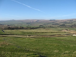
Birdoswald Roman Fort was known as Banna in Roman times, reflecting the geography of the site on a triangular spur of land bounded by cliffs to the south and east commanding a broad meander of the River Irthing in Cumbria below.

Arthuret is a civil parish in the Carlisle district of Cumbria, England. According to the 2001 census it had a population of 2,434, increasing to 2,471 at the 2011 Census. The parish includes the town of Longtown and the village of Easton. It is bounded by the River Esk to the west and the River Lyne to the south.

Bremenium is an ancient Roman fort (castrum) located at Rochester, Northumberland, England. The fort is part of the defensive system built along the extension of Dere Street, a Roman road running from York to Corbridge and onwards to Melrose. Significantly the fort is a long way north of Hadrian's Wall. It was one of the last forts north of Hadrian's wall to remain occupied until the 270s.

Arbeia was a large Roman fort in South Shields, Tyne & Wear, England, now ruined, and which has been partially reconstructed. It was first excavated in the 1870s. All modern buildings on the site were cleared in the 1970s. It is managed by Tyne and Wear Museums as Arbeia Roman Fort and Museum.

Magnis or Magna was a Roman fort near Hadrian's Wall in northern Britain. Its ruins are now known as Carvoran Roman Fort and are located near Carvoran, Northumberland, in northern England. It was built on the Stanegate frontier and Roman road, before the building of Hadrian's Wall.
Luguvalium was an ancient Roman city in northern Britain located within present-day Carlisle, Cumbria, and may have been the capital of the 4th-century province of Valentia. It deserves better recognition as the most northerly city of the Roman Empire.

Pons Aelius, or Newcastle Roman Fort, was an auxiliary castra and small Roman settlement on Hadrian's Wall in the Roman province of Britannia Inferior, situated on the north bank of the River Tyne close to the centre of present-day Newcastle upon Tyne, and occupied between the 2nd and 4th centuries AD.

Carrawburgh is a settlement in Northumberland. In Roman times, it was the site of a 3+1⁄2-acre (1.5 ha) auxiliary fort on Hadrian's Wall called Brocolitia, Procolita, or Brocolita.
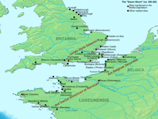
The Saxon Shore was a military command of the Late Roman Empire, consisting of a series of fortifications on both sides of the Channel. It was established in the late 3rd century and was led by the "Count of the Saxon Shore". In the late 4th century, his functions were limited to Britain, while the fortifications in Gaul were established as separate commands. Several well-preserved Saxon Shore forts survive in east and south-east England.

Longovicium was an auxiliary fort located on Roman Dere Street, in the Roman province of Britannia Inferior. It is located just southwest of Lanchester in the English county of Durham, roughly 8 miles (13 km) to the west of the city of Durham and 5 miles (8 km) from Consett.

Aballava or Aballaba was a Roman fort on Hadrian's Wall, between Petriana (Stanwix) to the east and Coggabata (Drumburgh) to the west. It is about one and a half miles south of the Solway Firth, and its purpose was to guard the south end of two important Solway fords, the Peat Wath and the Sandwath, which were also to become favourite routes for medieval border raiders.
Habitancum was an ancient Roman fort (castrum) located at Risingham, Northumberland, England. The fort was one of series of built along the extension of Dere Street, a Roman road running from York to Corbridge and onwards to Melrose, in Scotland.

Bewcastle Roman Fort was built to the north of Hadrian's Wall as an outpost fort possibly intended for scouting and intelligence. The remains of the fort are situated at the village of Bewcastle, Cumbria, 7 miles (11 km) to the north of the Roman fort at Birdoswald, on Hadrian's Wall.
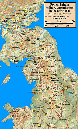
Blatobulgium was a Roman fort, located at the modern-day site known as Birrens, in Dumfriesshire, Scotland. It protected the main western road to Scotland.
The castra of Călugăreni was a fort in the Roman province of Dacia. The fort was erected in the 2nd century AD. Archaeological research also proved the existence of a nearby canabae. Abandoned in the 3rd century, the ruins of the fort are located in Călugăreni, Romania.
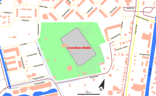
Matilo or Matilone was once a Roman fort (castellum) in modern-day Leiden. Positioned on the southern banks of the Oude Rijn, it served to protect the Roman borders in the province of Germania Inferior. On the Peutinger map, it lies between the encampments of Albaniana and Praetorium Agrippinae (Valkenburg). The seventh-century Ravenna Cosmography gives its name as Matellionem.
The Cohors VI Nerviorum was an auxiliary unit of Roman Army Cohors quinquagenaria peditata type attested in the Roman province of Britannia from the second century to the early fifth century AD.

Virosidum was a Roman fort and settlement situated near to the modern town of Bainbridge, North Yorkshire, England. The site is a Scheduled monument.