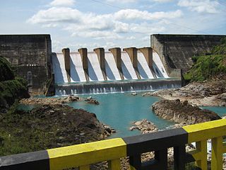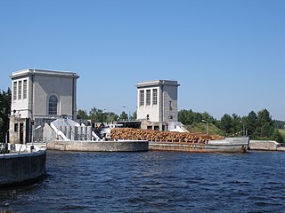
The Itaipu Dam is a hydroelectric dam on the Paraná River located on the border between Brazil and Paraguay. It is the third largest hydroelectric dam in the world, and holds the 45th largest reservoir in the world.
The Upper Salmon Hydro Development, a hydroelectric plant in Newfoundland and Labrador. It utilises a portion of the residual head between Meelpaeg Lake Reservoir and Round Pond within the watershed of the Bay d'Espoir Hydroelectric Development.
The Paradise River Hydroelectric Generating Station is a hydroelectric generating plant located near the mouth of the Paradise River in Newfoundland and Labrador. The plant is owned by Newfoundland and Labrador Hydro, and was first synchronized in 1989. It operates with an average rated flow of 25 m3/s to generate 8 MW of electrical power, with an average annual production of 37 GWh. The unit is equipped with a Francis runner. The project, which operates under a run-of-river philosophy, has a 43m high concrete arch dam with an overflow spillway, the largest structure of this design in Eastern North America.
The Granite Canal Hydroelectric Generating Station is a component of the Newfoundland and Labrador Hydro Corporation's Bay d’Espoir Hydro Electric Development system. The generating station has a rated capacity of 40 MW with an annual average energy production of 224 gigawatt hours (GWh). The generating unit at Granite Canal utilizes approximately 37 metres of head with a rated plant flow of 122.4 cubic metres per second. The unit is equipped with a Kaplan turbine and was first synchronized on May 26, 2003.

The Colorado–Big Thompson Project is a federal water diversion project in Colorado designed to collect West Slope mountain water from the headwaters of the Colorado River and divert it to Colorado's Front Range and plains. In Colorado, approximately 80% of the state's precipitation falls on the West Slope, in the Rocky Mountains, while around 80% of the state's growing population lives along the eastern slope, between the cities of Fort Collins and Pueblo.

Tarbela Dam is an earth-filled dam along the Indus River in Pakistan's Khyber Pakhtunkhwa province. It is located mainly in the Haripur District of the province. It is about 20 km (10 mi) from the city of Haripur, 105 km (65 mi) northwest of Islamabad, and 125 km (80 mi) east of Peshawar. It is the largest earth-filled dam in the world. The dam is 143 metres (470 ft) high above the riverbed and its reservoir, Tarbela Lake, has a surface area of approximately 250 square kilometres (97 sq mi).

Dworshak Dam is a concrete gravity dam in the western United States, on the North Fork of the Clearwater River in north central Idaho. In Clearwater County, the dam is located approximately four miles (6 km) northwest of Orofino and impounds the Dworshak Reservoir for flood control and hydroelectricity generation.

Lajoie Dam is the uppermost of the storage dams of BC Hydro's Bridge River Power Project, which is located in the southwestern Interior of British Columbia. It is located just west of the small semi-ghost town of Gold Bridge. An earthfill structure, it is 87 m and impounds c. 570,000 acre-feet (700,000,000 m3) of water in Downton Lake Reservoir. The Lajoie Powerhouse generates 22 MW with an average generating capacity of 170 GWh/year. A few miles downstream is Carpenter Lake, which is formed by Terzaghi Dam, the largest of the Bridge River Power Project's structures.

Nagarjuna Sagar Dam is a masonry dam across the Krishna River at Nagarjuna Sagar which straddles the border between Palnadu district in Andhra Pradesh and Nalgonda district in Telangana. The dam provides irrigation water to the districts of Palnadu, Guntur, Nalgonda, Prakasam, Khammam, Krishna, and parts of West Godavari. It is also a source of electricity generation for the national grid.

Lake Qaraoun is an artificial lake or reservoir located in the southern region of the Beqaa Valley, Lebanon. It was created near Qaraoun village in 1959 by building a 61 m-high (200 ft) concrete-faced rockfill dam in the middle reaches of the Litani River. The reservoir has been used for hydropower generation, domestic water supply, and for irrigation of 27,500 ha.

The Oroville–Thermalito Complex is a group of reservoirs, structures, and facilities located in and around the city of Oroville in Butte County, California. The complex serves not only as a regional water conveyance and storage system, but is the headwaters for, and therefore perhaps is the most vital part of, the California Department of Water Resources' State Water Project, as one of the largest publicly built and operated water and power development and conveyance systems.

Dimitrie Leonida (Stejaru) Hydro Power Plant is a hydropower development on the Bistrița River, near Bicaz, Romania.

Rangit Dam, which forms the headworks of the Rangit Hydroelectric Power Project Stage III, is a run-of-the-river hydroelectric power project on the Ranjit River, a major tributary of the Teesta River in the South Sikkim district of the Northeastern Indian state of Sikkim. The project's construction was completed in 1999. The project is fully functional since 2000. The project was built at a cost of Rs 4922.6 million. The average annual power generation from the 60 MW project is 340 GWh with firm power of 39 MW.

The Upper Kotmale Dam is located in Talawakele, within the Nuwara Eliya District, in the Central Province of Sri Lanka. The dam feeds the third largest hydroelectric power station in the country.

The Randenigala Dam is a large hydroelectric embankment dam at Rantembe, in the Central Province of Sri Lanka. Construction of the dam began in November 1982, and was completed in approximately 4 years. The dam and power station was ceremonially opened by then President J. R. Jayawardene in 1986.

The Castlereigh Dam is a gravity dam built across the Kehelgamu Oya, a major tributary to the Kelani River, approximately 3 km (1.9 mi) south-west of Hatton, in the Central Province of Sri Lanka.

The Upper North Fork Feather River Project is a hydroelectric scheme in the Sierra Nevada of California, within Lassen and Plumas Counties. The project consists of three dams, five power plants, and multiple conduits and tunnels in the headwaters of the North Fork Feather River, a major tributary of the Feather—Sacramento River systems. The total installed capacity is 362.3 megawatts (MW), producing an annual average of 1,171.9 gigawatt hours (GWh). The project is also contracted for the delivery of irrigation water between March 31 and October 31 of each year. The project is owned and operated by Pacific Gas and Electric Company.
The Kukule Ganga Dam is a 110 m (360 ft) gravity dam built across the Kukule River in Kalawana, Sri Lanka. The run-of-river-type dam feeds an underground hydroelectric power station located approximately 5 kilometres (3.1 mi) away, via tunnel.

Kopili Hydro Electric Project is a 275 megawatts (369,000 hp), hydroelectric power project on the Kopili river and its tributary, Umrong stream. It is located in Dima Hasao district of Assam state in India. The project is developed and operated by North Eastern Electric Power Corporation Limited. It is an important project since the indian State of Assam, Arunachal Pradesh, Manipur, Meghalaya, Mizoram, Nagaland and Tripura benefit from this project.


