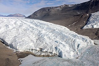
The Taylor Glacier is a glacier in Antarctica about 35 nautical miles long, flowing from the plateau of Victoria Land into the western end of Taylor Valley, north of the Kukri Hills. It flows to the south of the Asgard Range. The middle part of the glacier is bounded on the north by the Inland Forts and on the south by Beacon Valley.

The Ames Range is a range of snow-covered, flat-topped, steep-sided mountains, extending in a north–south direction for 20 nautical miles and forming a right angle with the eastern end of the Flood Range in Marie Byrd Land, Antarctica.
Rowett Island is a rocky island 0.5 miles (0.8 km) long, lying immediately off Cape Lookout, Elephant Island, in the South Shetland Islands. Rowett Island is located at 61°17′S55°13′W. Rowett Island was known to American and British sealers as early as 1822. Rowett Island was named by members of a British expedition (1921-1922) under Ernest Shackleton for John Quiller Rowett, chief patron of the expedition.

Quito Glacier is a glacier draining the northeast slopes of Mount Plymouth and flowing northeastwards into the sea west of Canto Point in north Greenwich Island, South Shetland Islands. It was named after the capital of Ecuador, c. 1990, by the Ecuadorian Antarctic Expedition.
Yankee Harbour is a small inner harbour entered from Shopski Cove between Glacier Bluff and Spit Point, indenting the south-west side of Greenwich Island in the South Shetland Islands, Antarctica. It is 2.35 km (1.46 mi) long in west-south-west to east-north-east direction, and 1.6 km (0.99 mi) wide, and is bounded by Provadiya Hook to the south-west, Parvomay Neck to the north and east, and Kladara Beach to the south.
Irizar Island is an island 0.8 km (0.5 mi) long, lying 0.80 km (0.5 mi) northeast of Uruguay Island in the northeastern part of the Argentine Islands, in the Wilhelm Archipelago, Antarctica. It was discovered by the French Antarctic Expedition, 1903–05, under Jean-Baptiste Charcot, and named by him for Captain Julián Irízar of the Argentine Navy. The island was recharted in 1935 by the British Graham Land Expedition under John Rymill.
Avian Island is an island, 1.2 km (0.7 mi) long and 40 metres (130 ft) high, lying close off the south tip of Adelaide Island, Antarctica. It was discovered by the French Antarctic Expedition, 1908–10, under Jean-Baptiste Charcot, and visited in 1948 by the Falkland Islands Dependencies Survey, who so named it because of the large number and variety of birds (avians) found there.
The Porthos Range is the second range south in the Prince Charles Mountains of Antarctica, extending for about 30 miles in an east-to-west direction between Scylla Glacier and Charybdis Glacier. First visited in December 1956 by the Australian National Antarctic Research Expeditions (ANARE) southern party under W.G. Bewsher (1956-57) and named after Porthos, a character in Alexandre Dumas, père's novel The Three Musketeers, the most popular book read on the southern journey.

Flask Glacier, is a gently-sloping glacier, 25 nautical miles long, flowing east from Bruce Plateau to enter Scar Inlet between Daggoo Peak and Spouter Peak in Graham Land, Antarctica. The lower reaches of this glacier were surveyed and photographed by the Falklands Islands Dependencies Survey (FIDS) in 1947. The entire glacier was photographed by the Falkland Islands and Dependencies Aerial Survey Expedition in 1955–56, and mapped by the FIDS in 1957. It was named by the UK Antarctic Place-names Committee after the third mate on the Pequod in Herman Melville's Moby-Dick; or, The White Whale.
Aphrodite Glacier is a glacier 15 nautical miles (28 km) long flowing north to the east coast of the Antarctic Peninsula 3 nautical miles (6 km) west of Victory Nunatak.
Breakwater Island is a small island in the Palmer Archipelago with a line of rocks extending in a southwest arc from it, lying opposite Nipple Peak, 0.3 nautical miles (0.6 km) off the east side of Wiencke Island. The descriptive name, suggestive of an artificial breakwater, was given by the Falkland Islands Dependencies Survey in 1944.
The Büdel Islands are a group of islands lying between Laktionov Island and Schule Island, off the east side of Renaud Island in the Biscoe Islands. First accurately shown on an Argentine government chart of 1957, they were named by the UK Antarctic Place-Names Committee in 1959 for Julius Büdel, German sea ice specialist.

Cadman Glacier is a glacier, 1.5 nautical miles (3 km) wide at its mouth and about 7 nautical miles (13 km) long, flowing northwestward into the head of the southern arm of Beascochea Bay south of Plas Point on the west side of the Antarctic Peninsula.
Vivaldi Glacier is a glacier lying between the Colbert Mountains and the Lully Foothills, flowing south from Purcell Snowfield into the head of Schubert Inlet on the west coast of Alexander Island, Antarctica. The feature appears to be first shown on maps of the United States Antarctic Service (USAS) which photographed Alexander Island from the air in 1940. It was mapped from air photos obtained by the Ronne Antarctic Research Expedition in 1947–48, by Searle of the Falkland Islands Dependencies Survey in 1960. Named "Vivaldi Gap" by the United Kingdom Antarctic Place-Names Committee in 1961, after Antonio Vivaldi (1678–1741), Venetian composer. The name was amended to Vivaldi Glacier following review of Landsat program imagery, 1979, displaying flow lines in the feature.
Planet Heights is a series of summits running along an ice-free ridge, extending 24 nautical miles (44 km) in a north-south direction between the southernmost extremity of the LeMay Range and George VI Sound in the east part of Alexander Island, Antarctica. Many landforms and nearby features are named in association with this mountain range; some of these include landforms named after astronomers, satellites, planets and other things related to astrology and astrophysics. The mountain range was first mapped from air photos taken by the Ronne Antarctic Research Expedition (RARE), 1947–48, by Searle of the Falkland Islands Dependencies Survey (FIDS) in 1960. Named by the United Kingdom Antarctic Place-Names Committee (UK-APC) from association with the nearby glaciers named for planets of the Solar System. The only planet that is not featured in any of these glaciers is the planet Earth, as there are no glaciers named "Earth Glacier" and this glacier does not exist.
Pollard Glacier is a glacier flowing into the south side of Comrie Glacier to the east of Bradford Glacier, on the west coast of Graham Land. Mapped by the Falkland Islands Dependencies Survey (FIDS) from photos taken by Hunting Aerosurveys Ltd. in 1956–57. Named by the United Kingdom Antarctic Place-Names Committee (UK-APC) for Alan F.C. Pollard (1877–1948), English documentalist, founder and first president of the British Society for International Bibliography, and pioneer in the introduction of the Universal Decimal Classification into British libraries.
The Phillips Mountains are a range of mountains on the north side of Balchen Glacier and Block Bay in the Ford Ranges, Marie Byrd Land, Antarctica.
Thomsen Islands is a group of small islands lying 2 nautical miles (3.7 km) southwest of Speerschneider Point, off the west side of Renaud Island in the Biscoe Islands. First accurately shown on an Argentine government chart of 1957. Named by the United Kingdom Antarctic Place-Names Committee (UK-APC) in 1959 for Helge Thomsen, Danish meteorologist, who, for a number of years beginning in 1946, was responsible for editing Dansk Meteorologisk Institut's annual reports on the state of the sea ice in the Arctic.
Rumbler Rock is a rock lying 3.5 nautical miles (6 km) west of Bonaparte Point, off the southwest coast of Anvers Island in the Palmer Archipelago of Antarctica. Surveyed by the British Naval Hydrographic Survey Unit in 1956–57. So named by the United Kingdom Antarctic Place-Names Committee (UK-APC) because with the prevailing heavy southwest swell, the noise of seas breaking over the rock may be heard well clear of the danger.