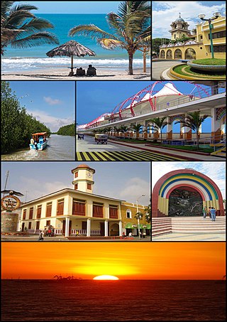
Piura is a city in northwestern Peru located in the Sechura Desert on the Piura River. It is the capital of the Piura Region and the Piura Province. Its population was 484,475 as of 2017.

Monsefú is a town in Northern Peru, capital of the Monsefú district in the Chiclayo Province that is part of the Lambayeque Region. It is renowned for its food and handicrafts, which are on display at the annual FEXTICUM festival, named in 1973 by Professor Limberg Chero Ballena and held in July during Fiestas Patrias. Monsefú is also the home of cumbia groups Grupo 5 and Hermanos Yaipen. Monsefú was elevated to the category of "city" on October 26, 1888.

San Vicente de Cañete, commonly known as San Vicente or Cañete, is a city and capital of the Cañete Province, in southern Lima Region. With a population of 85,533.

Huánuco is a city in central Peru. It had a population of 196,627 as of 2017 and in 2015 it had a population of 175,068. It is the capital of the Huánuco Region and the Huánuco District. It is the seat of the diocese of Huánuco. The metropolitan city of Huanuco is 170,000 hab. It has three districts, Huanuco (head), Amarilis, and Pillco Marca. In this city, the Higueras river meets the Huallaga river, one of the largest rivers in the country.
Tumbes is a city in northwestern Peru, on the banks of the Tumbes River. It is the capital of the Tumbes Region, as well as of Tumbes Province and Tumbes District. Located near the border with Ecuador, Tumbes has 111,595 inhabitants as of 2015. It is served by the Cap. FAP Pedro Canga Rodriguez Airport. It is located on the Gulf of Guayaquil along with Zorritos.

Sechura is a town in northwestern Peru, 50 km (31 mi) south of Piura. It is the capital of Sechura Province in the Piura Region. The city lends its name to the Sechura Desert, which extends south along most of coastal Peru. Crescent dunes lie south of the city, between the sea and the highway.

Paita is a city in northwestern Peru. It is the capital of the Paita Province which is in the Piura Region. It is a leading seaport in the region. Paita is located 1,089 km northwest of the country's capital Lima, and 57 km northwest of the regional capital of Piura. Starting in 2014, the city has considered ideas for separating from the Piura Region, proclaiming itself as the "Miguel Grau Region".

Sullana is the capital of the Sullana Province, in the north-western coastal plains of Peru on the Chira valley.

Talara is a city in the Talara Province of the Piura Region, in northwestern Peru. It is a port city on the Pacific Ocean with a population of 91,444 as of 2017. Its climate is hot and dry. Due to its oil reserves, and ability to produce aviation fuel, Talara hosted a United States air base during World War II. It was also one of two refueling stations for the Pacific Fleet. There were naval guns on the hills, and submarine nets in the harbor. The Ajax, Achilles and Exeter, three British destroyers, were refuelled there on their way around the Horn to catch the Graf Spee in Rio de la Plata. Talara is also home to a large fishing fleet. The city is served by the Cap. FAP Víctor Montes Arias Airport.
Rioja is the capital of Rioja Province in the San Martín Region in northern Peru. It is situated to the west of Moyobamba. There are 24,263 inhabitants according to the 2007 census.

Andahuaylas is a Peruvian city. It is the capital of the Andahuaylas Province in the Apurímac Region. It is known as the pradera de los celajes. Its approximate population of 42,268 inhabitants makes it the largest city in the region.

Chulucanas is a town in Morropón Province, Piura Region, Peru. It lies in the Piura Valley just north of the confluence of the Charanal River with the Piura River. Chulucanas is the administrative seat for both Chulucanas District and Morropón Province.
Bagua Grande is a town in the Amazonas region in northern Peru. It is capital of Utcubamba Province, and of Bagua Grande District. Bagua Grande has an estimated 42,396 inhabitants, having changed from a rural to an urban area after experiencing much immigration in the 1960s. It is called by its inhabitants Corazón de Amazonas.

Huaral is a town in central Peru, capital of the Huaral Province in the Department of Lima.

Chepén is a city of La Libertad Region and capital of the Chepén Province, in Peru. The city is a rice production center with the valleys of Chepén and Jequetepeque, and has an active trading with neighboring Guadalupe, Pacasmayo and San Pedro de Lloc and other towns. It has factories in industrial dyes, food and primary production.
Guadalupe is a city in Northern Peru, capital of the district Guadalupe in the region La Libertad. This town is located some 127 km north Trujillo city and is primarily an agricultural center in the Jequetepeque Valley.
Casa Grande is a town in Northern Peru, capital of the district of Casa Grande of Ascope Province in the region La Libertad. This town is located beside the Pan-American Highway some 48 km north of Trujillo city in the agricultural Chicama Valley.
The Piura Metropolitan Area is the name used to refer to the metropolitan area whose principal city is Piura, located in northern Peru. According to "Concerted development plan Piura 2009–2014" the districts of Piura, Veintiséis de Octubre, Castilla and Catacaos of Piura Province currently are consolidated into a metropolitan area to act with the same urban, industrial and commercial plan. It is one of the most populous metropolitan area of Peru in year 2015.

From December 2016 and continuing until May 2017, much of western and central South America was plagued by persistent heavy rain events. In Peru, one of the most severely impacted nations, it has been referred to as the 2017 Coastal Niño. The flooding was preceded by drought-like conditions throughout the region for much of 2016 and a strong warming of sea temperatures off the coast of Peru.