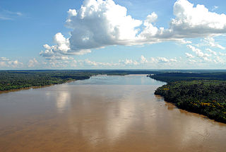
The Madeira River is a major waterway in South America. It is estimated to be 1,450 km (900 mi) in length, while the Madeira-Mamoré is estimated near 3,250 km (2,020 mi) or 3,380 km (2,100 mi) in length depending on the measuring party and their methods. The Madeira is the biggest tributary of the Amazon, accounting for about 15% of the water in the basin. A map from Emanuel Bowen in 1747, held by the David Rumsey Map Collection, refers to the Madeira by the pre-colonial, indigenous name Cuyari:
The River of Cuyari, called by the Portuguese Madeira or the Wood River, is formed by two great rivers, which join near its mouth. It was by this River, that the Nation of Topinambes passed into the River Amazon.

Peru is a country on the central western coast of South America facing the Pacific Ocean. It lies wholly in the Southern Hemisphere, its northernmost extreme reaching to 1.8 minutes of latitude or about 3.3 kilometres (2.1 mi) south of the equator. Peru shares land borders with Ecuador, Colombia, Brazil, Bolivia, and Chile, with its longest land border shared with Brazil.

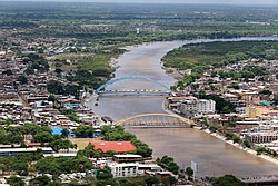
Piura is a city in northwestern Peru located in the Sechura Desert on the Piura River. It is the capital of the Piura Region and the Piura Province. Its population was 484,475 as of 2017.

Piura is a coastal department and region in northwestern Peru. The region's capital is Piura and its largest port cities, Paita and Talara, are also among the most important in Peru. The area is known for its tropical and dry beaches. It is the most populous department in Peru, its twelfth smallest department, and its fourth-most densely populated department, after Tumbes, La Libertad, and Lambayeque.
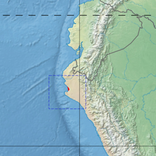
The Sechura Desert is a coastal desert located south of the Piura Region of Peru along the Pacific Ocean coast and inland to the foothills of the Andes Mountains. Its extreme aridity is caused by the upwelling of cold coastal waters and subtropical atmospheric subsidence, but it is also subject to occasional flooding during El Niño years. In 1728, the town of Sechura was destroyed by a tsunami and was later rebuilt in its present location. In 1998, runoff from flooding rivers caused the formation of a temporary lake some 90 mi (145 km) long filling the Bayóvar Depression. Short rivers flowing across the desert from the Andes support intensive irrigation-based agriculture.

Poechos Reservoir is a middle-sized reservoir on Peru's Chira River in the border area between Peru and Ecuador. Its purpose is to improve the accumulation of water stocks in the upper part of Peru's Chira basin by flood control, irrigation, drainage and electricity generation.
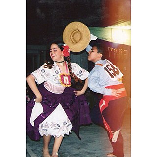
Tondero is a dance and guitar rhythm from Peru that developed in the country's northern coastal region (Piura–Lambayeque).

Climate of Peru describes the diverse climates of this large South American country with an area of 1,285,216 km2 (496,225 sq mi). Peru is located entirely in the tropics but features desert and mountain climates as well as tropical rainforests. Elevations above sea level in the country range from −37 to 6,778 m and precipitation ranges from less than 20 mm (0.79 in) annually to more than 8,000 mm (310 in). There are three main climatic regions: the Pacific Ocean coast is one of the driest deserts in the world but with some unique features; the high Andes mountains have a variety of microclimates depending on elevation and exposure and with temperatures and precipitation from temperate to polar and wet to dry; and the Amazon basin has tropical climates, mostly with abundant precipitation, along with sub-tropical climates in elevations above 1,550 m (5,090 ft).

The Loa River is a U-shaped river in Chile's northern Antofagasta Region. At 440 km (270 mi) long, it is the country's longest river and the main watercourse in the Atacama Desert.

The Maipo River is the main river flowing through the Santiago Metropolitan Region and the Valparaiso Region of Chile. It is located just south of the capital of Santiago. The Mapocho River, which flows through central Santiago, is one of its tributaries. Its headwaters are on the west slope of Maipo volcano, in the Andes. The Maipo River is by far the major source of irrigation and potable water for the region.
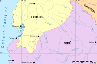
Chira River or Rio Chira is the name of a river in northern Peru whose mouth is 100 km north west of the provincial capital of Piura and 25 km north of the port of Paita.
While Peru accounts for about four per cent of the world's annual renewable water resources, over 98% of its water is available east of the Andes, in the Amazon region. The coastal area of Peru, with most of economic activities and more than half of the population, receives only 1.8% of the national freshwater renewable water resources. Economic and population growth are taking an increasing toll on water resources quantity and quality, especially in the coastal area of Peru.

The Catacaoan languages are an extinct family of three languages spoken in the Piura Region of Peru. The three languages in the family are:

Motupe River is a river of Lambayeque Region in northwestern Peru. The Motupe River Basin, which includes its major tributary the La Leche River, is bounded by the Chancay-Lambayeque River Basin to the south, by the Olmos River Basin to the north, by the river basins of the Chotano and Huancabamba to the east, and on the west by the Pacific Ocean. The river receives its name from the village of Motupe, nearby where the Motupe River is formed.
La Leche River, meaning the milky one, is a river of Lambayeque Region in northwestern Peru, although some of its water come from the northern Cajamarca Region.
Olmos River, is a river in the Lambayeque Region in northwestern Peru. It flows off the west slopes of the Andes and its tributaries, such as Los Boliches, carry little additional water. As a result, it is a low flow stream, intermittent in its lower reaches only flowing during the rainy season. Before it can reach the Pacific Ocean it disappears into the alluvium of the Sechura Desert. The Olmos River is 91 kilometres (57 mi) long and its river basin covers 965.0 square kilometres (373 sq mi).

The Tumbes–Piura dry forests (NT0232) is an arid tropical ecoregion along the Pacific coasts of southern Ecuador and northern Peru. The ecoregion contains many endemic species of flora and birds adapted to the short wet season followed by a long dry season. Threats include extraction of wood for fuel or furniture, and capture of wild birds for sale.

The Zaña River is a small river in northern Peru. The river is 119 kilometres (74 mi) in length and begins in the Andes of Cajamarca Region and ends at the Pacific Ocean in Lambayeque Region. In the lower part of the river valley, where the river flows through the coastal desert of Peru, the cultivation of irrigated crops is extensive and the Zaña is usually dry near its mouth. Upriver, at higher elevations in the Andes, precipitation is much greater and downstream floods are common. One such flood wiped out the important city of Zaña in 1720. Zaña has been rebuilt, but has never regained its former prominence as an urban center. Other towns in the lower valley are Mocupe, Cayalti, Nueva Arica, and Oyotun.
The Piura mangroves ecoregion covers a very small mangrove site on the Piura River Delta, on the Pacific Ocean in northwestern Peru. This small mangrove site is at the northern tip of the Sechura Desert. The climate is normally semi-arid, but cn be much wetter in El Nino years. The area is a RAMSAR wetland of international importance "Manglares de San Pedro de Vice", and is an important stopover for migratory birds.