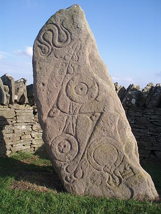
The Picts were a group of peoples in northern Britain, north of the Firth of Forth, in the Early Middle Ages. Where they lived and details of their culture can be gleaned from early medieval texts and Pictish stones. The name Picti appears in written records as an exonym from the late third century AD. They are assumed to have been descendants of the Caledonii and other northern Iron Age tribes. Their territory is referred to as "Pictland" by modern historians. Initially made up of several chiefdoms, it came to be dominated by the Pictish kingdom of Fortriu from the seventh century. During this Verturian hegemony, Picti was adopted as an endonym. This lasted around 160 years until the Pictish kingdom merged with that of Dál Riata to form the Kingdom of Alba, ruled by the House of Alpin. The concept of "Pictish kingship" continued for a few decades until it was abandoned during the reign of Caustantín mac Áeda.
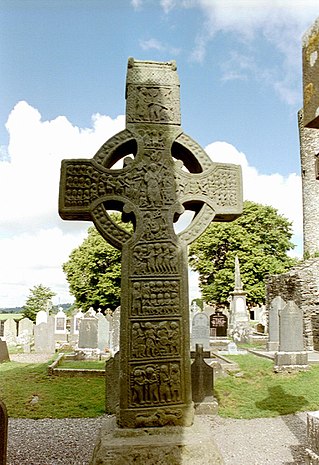
A high cross or standing cross is a free-standing Christian cross made of stone and often richly decorated. There was a unique Early Medieval tradition in Ireland and Britain of raising large sculpted stone crosses, usually outdoors. These probably developed from earlier traditions using wood, perhaps with metalwork attachments, and earlier pagan Celtic memorial stones; the Pictish stones of Scotland may also have influenced the form. The earliest surviving examples seem to come from the territory of the Anglo-Saxon kingdom of Northumbria, which had been converted to Christianity by Irish missionaries; it remains unclear whether the form first developed in Ireland or Britain.

A callus is an area of thickened and sometimes hardened skin that forms as a response to repeated friction, pressure, or other irritation. Since repeated contact is required, calluses are most often found on the feet and hands, but they may occur anywhere on the skin. Some degree of callus, such as on the bottom of the foot, is normal.

Cowal is a rugged peninsula in Argyll and Bute, on the west coast of Scotland. It is bounded on the west by Loch Fyne and on the east by Loch Long and the Firth of Clyde. The Kyles of Bute separate it from Bute to the south.

Aboyne is a village on the edge of the Highlands in Aberdeenshire, Scotland, on the River Dee, approximately 30 miles (48 km) west of Aberdeen. It has a swimming pool at Aboyne Academy, all-weather tennis courts, a bowling green and is home to the oldest 18 hole golf course on Royal Deeside. Aboyne Castle and the Loch of Aboyne are nearby.

Abernethy is a village and former burgh in the Perth and Kinross council area and historic county of Perthshire, in the east central Lowlands of Scotland.

Aberdeenshire or the County of Aberdeen is a historic county and registration county of Scotland. The area of the county, excluding the Aberdeen City council area itself, is also a lieutenancy area. The county borders Kincardineshire, Angus and Perthshire to the south, Inverness-shire and Banffshire to the west, and the North Sea to the north and east. It has a coast-line of 65 miles (105 km). The county gives its name to the modern Aberdeenshire council area, which covers a larger area than the historic county.
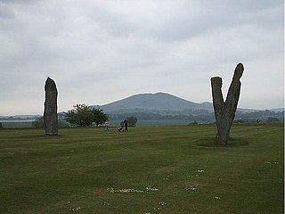
Lundin Links is a small village in the parish of Largo on the south coast of Fife in eastern central Scotland.

Fauldhouse is a village in West Lothian, Scotland. It is about halfway between Glasgow and Edinburgh. The nearest towns to Fauldhouse are Whitburn and Livingston. Other neighbouring villages include Longridge, Shotts and Stoneyburn. At approximately 750 feet above sea level, Fauldhouse is one of the highest villages in West Lothian.

The Monymusk Reliquary is an eighth century Scottish house-shape reliquary made of wood and metal characterised by an Insular fusion of Gaelic and Pictish design and Anglo-Saxon metalworking, probably by Ionan monks. It is now in the National Museum of Scotland in Edinburgh.

The Callanish IV stone circle is one of many megalithic structures around the better-known Calanais I on the west coast of the Isle of Lewis, in the Outer Hebrides, Scotland. It is a scheduled monument and its official name is Sron a'Chail. The site was first surveyed and recorded by RCAHMS in 1914 and again in 2009, with another survey in the 1970s by other archaeologists, but no known archaeological excavations have taken place at the stones.

Strichen stone circle is a Megalithic recumbent stone circle located near Strichen, Aberdeenshire in the north east of Scotland. It has been destroyed twice and in the early 1980s was excavated and reconstructed.

Carved stone balls are petrospheres dated from the late Neolithic, to possibly as late as the Iron Age, mainly found in Scotland, but also elsewhere in Britain and Ireland. They are usually round and rarely oval, and of fairly uniform size at around 2+3⁄4 inches or 7 cm across, with anything between 3 and 160 protruding knobs on the surface. They range from having no ornamentation to extensive and highly varied engraved patterns. A wide range of theories has been produced to explain their use or significance, with none gaining very wide acceptance.

The Eassie Stone is a Class II Pictish stone of about the mid 8th century AD in the village of Eassie, Angus, Scotland. The stone was found in Eassie burn in the late 18th century and now resides in a purpose-built perspex building in the ruined Eassie church.
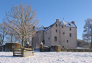
Hatton Castle stands on the lower part of Hatton Hill, the most easterly of the Sidlaw Hills, to the south of Newtyle in Angus, Scotland. The castle overlooks the wooded Den of Newtyle, and its views extend across Strathmore and include Ben Lawers and Schiehallion as well as the Angus and Glenshee hills. The 16th-century castle was originally built in a typical Scottish "Z plan" tower house design, as a fortified country house or château. There was an earlier castle called Balcraig Castle which stood less than half a mile from the present building, also on Hatton Hill.
Christian Maclagan was a Scottish antiquarian and early archaeologist. She is known for her collection of rubbings of Celtic crosses and Pictish stones from across Scotland, and was a pioneer of stratigraphic excavation. Although she lost the use of her right hand due to a medical condition she nevertheless produced numerous drawings, sketches and paintings with her left hand. She took action to help those affected by poverty in Stirling. She refused to sit for portraits although one obituary described her as tall. She was a suffragist. She wrote an autobiography but the script remains lost. She was nominated to be one of Scotland's Heroines honoured at the National Wallace Monument's Hall of Heroes. She died in Ravenscroft, Stirling.
The Aberlemno Sculptured Stones are a series of Pictish standing stones originating in and around the village of Aberlemno, Angus, Scotland. Three are located in the village and a fourth, found in 1962, is on display in The McManus in Dundee. They date from the Early Medieval period. A fifth stone standing in the village has signs of carving, but is of unknown authenticity as a Pictish artefact.
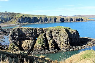
Dunnicaer, or Dun-na-caer, is a precipitous sea stack just off the coast of Aberdeenshire, Scotland, between Dunnottar Castle and Stonehaven. Despite the unusual difficulty of access, in 1832 Pictish symbol stones were found on the summit and 21st-century archaeology has discovered evidence of a Pictish hill fort which may have incorporated the stones in its structure. The stones may have been incised in the third or fourth centuries AD but this goes against the general archaeological view that the simplest and earliest symbol stones date from the fifth or even seventh century AD.
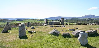
Tomnaverie stone circle is a recumbent stone circle set on the top of a small hill in lowland northeast Scotland. Construction started from about 2500 BC, in the Bronze Age, to produce a monument of thirteen granite stones including a massive 6.5-ton recumbent stone lying on its side along the southwest of the circle's perimeter. Within the 17-metre (56 ft) circle are kerb stones encircling a low 15-metre (49 ft) ring cairn but the cairn itself no longer exists.

Tyrebagger stone circle is located at Dyce, near to Aberdeen in Scotland. It is a complete recumbent stone circle. It was used as a cattle pound in the past and now stands close to the Aberdeen Western Peripheral Route. It is a scheduled monument since 1925.


