The Causeway Islands (Spanish: Islas Calzada de Amador) are four small islands by the Pacific entrance to the Panama Canal. They are linked to the mainland via a causeway, made from rock extracted during the excavations from the Panama Canal. In part the causeway was meant to serve as a breakwater for the entrance.
A four-lane road runs along the causeway to each island, and there is a bicycle/jogging path as well.
During World War II, fortifications were constructed on the islands to protect the canal but were never used. They have since been dismantled, but bulwarks and empty gun emplacements still exist.
Launch facilities are used by pilots boarding ships entering the Panama Canal from these islands.
Manuel Noriega built a private house on one of the islands, which was destroyed and looted during his ouster.
Since control of the islands reverted to Panama (they had previously been part of the Canal Zone), there has been considerable development along the causeway and edges of the islands, including port facilities, marinas, shopping, and restaurants. Away from their perimeters, the hilly islands still contain isolated maritime jungle, though they are threatened by continued development.
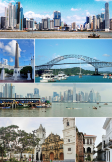
Panama City, also simply known as Panama, is the capital and largest city of Panama. It has an urban population of 880,691, with over 1.5 million in its metropolitan area. The city is located at the Pacific entrance of the Panama Canal, in the province of Panama. The city is the political and administrative center of the country, as well as a hub for banking and commerce.
A causeway is a track, road or railway on the upper point of an embankment across "a low, or wet place, or piece of water". It can be constructed of earth, masonry, wood, or concrete. One of the earliest known wooden causeways is the Sweet Track in the Somerset Levels, England, which dates from the Neolithic age. Timber causeways may also be described as both boardwalks and bridges.
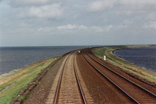
The Panama Canal Railway is a railway line linking the Atlantic Ocean to the Pacific Ocean in Central America. The route stretches 47.6 miles (76.6 km) across the Isthmus of Panama from Colón (Atlantic) to Balboa. Because of the difficult physical conditions of the route and state of technology, the construction was renowned as an international engineering achievement, one that cost US$8 million and the lives of an estimated 5,000 to 10,000 workers. Opened in 1855, the railway preceded the Panama Canal by half a century; the ship canal was later constructed parallel to the railway.
Balboa is a district of Panama City, located at the Pacific entrance to the Panama Canal.
The Smithsonian Tropical Research Institute is located in Panama and is the only bureau of the Smithsonian Institution based outside of the United States. It is dedicated to understanding the past, present, and future of tropical ecosystems and their relevance to human welfare. STRI grew out of a small field station established in 1923 on Barro Colorado Island in the Panama Canal Zone to become one of the world's leading tropical research organizations. STRI's facilities provide for long-term ecological studies in the tropics and are used by some 1,200 visiting scientists from academic and research institutions around the world every year.
Taboga Island, also known as the "Island of Flowers", is a volcanic island in the Gulf of Panama. It is a tourist destination, about 20 km from Panama City, Panama.
The Bridge of the Americas is a road bridge in Panama, which spans the Pacific entrance to the Panama Canal. Designed by Sverdrup & Parcel, it was completed in 1962 at a cost of US$20 million, connecting the north and south American land masses. Two other bridges cross the canal: the Atlantic Bridge at the Gatun locks and the Centennial Bridge.
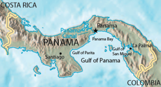
The Gulf of Panama is a gulf in the Pacific Ocean, near the southern coast of Panama. It has a maximum width of 250 kilometres (160 mi), a maximum depth of 220 metres (720 ft) and the size of 2,400 square kilometres (930 sq mi). The Panama Canal connects the Gulf of Panama with the Caribbean Sea and the Pacific Ocean. The Panamanian capital Panama City is the main urban centre on the gulf shore.
State Road 913 is an access road between the village of Key Biscayne on the island of Key Biscayne and I-95 in Miami on the western end of Biscayne Bay. The only part that is state maintained is South 26th Road ; Miami-Dade County maintains the Rickenbacker Causeway across the Biscayne Bay and Virginia Key to Key Biscayne. Inside the village of Key Biscayne, the roadway is known as Crandon Boulevard after it crosses Bear Cut. Mile markers are posted along the entire route, with zero at the entrance to Bill Baggs Cape Florida State Park at the south end of Crandon Boulevard.
Ancón is a corregimiento in Panamá District, Panamá Province, Panama with a population of 29,761 as of 2010. Its population as of 1990 was 11,518; its population as of 2000 was 11,169. It is sometimes considered a suburb or small town within Panama City, northeast of the limits of the town of Balboa. Ancon Hill is also the name of a large hill that overlooks Panama City and once served as a form of protection from pirates and sea invasion. The township was originally located around this hill, and was created to house employees of the Panama Canal during its construction. As part of the construction effort, the historic Gorgas Army Hospital was founded and built on the hillside. The first ship to officially transit the canal, SS Ancon, was named after the district. The community continued to serve as housing for employees of the Panama Canal Company until 1980, when parts of it began to be turned over to the Panamanian government under the 1977 Torrijos-Carter Treaties. Modern-day Ancón is a corregimiento of Panama City, serving mainly as a residential area. The Gorgas Army Hospital building is now the Panamanian Oncology Hospital, primarily used for cancer research. The area also houses Panama's Supreme Court, just a few feet away from the Gorgas Army Hospital building, and several Smithsonian Tropical Research Institute buildings for research into tropical biology. Ancón is also a parish (parroquia) of the District of Panama, located in the Panama Canal adjacent area.
Fort Sherman is a former United States Army base in Panama, located on Toro Point at the Caribbean (northern) end of the Panama Canal, on the western bank of the Canal directly opposite Colón. It was the primary defensive base for the Caribbean sector of the Canal, and was also the center for US jungle warfare training for some time. Its Pacific-side partner was Fort Amador. Both bases were turned over to Panama in 1999.
Fort Amador and Fort Grant were former United States Army bases built to protect the Pacific (southern) end of the Panama Canal at Panama Bay. Amador was the primary on-land site, lying below the Bridge of the Americas. Grant consisted of a series of islands lying just offshore, some connected to Amador via a causeway. Fort Sherman was the corresponding base on the Atlantic (northern) side. All of the forts were turned over to the Republic of Panama in 1999, and the area is now a major tourist attraction.
The Rickenbacker Causeway is a causeway which connects Miami, Florida, United States to the barrier islands of Virginia Key and Key Biscayne across Biscayne Bay.
Figali Convention Center is an indoor sports arena, in Fort Amador, Panama City, Panama. The capacity of the arena is 25,000.
Gamboa is a small town in the Republic of Panama. It was one of a handful of permanent Canal Zone townships, built to house employees of the Panama Canal and their dependents. The name Gamboa is the name of a tree of the quince family.
The University of Panama was founded on October 7, 1935, with a student body of 175 in the fields of Education, Commerce, Natural Sciences, Pharmacy, Pre-Engineering and Law. As of 2008, it maintains a student body of 74,059 distributed in 228 buildings across the country.
Gatun is a small town on the Atlantic Side of the Panama Canal, located south of the city of Colón at the point in which Gatun Lake meets the channel to the Caribbean Sea. The town is best known as the site of the Panama Canal's Gatun Locks and Gatun Dam, built by the United States between 1906–1914.
Florida State University-Panama, or FSU-Panama is an international branch campus of Florida State University located on the isthmus of Panama. FSU has operating a broad curriculum program in Panama City of the Republic of Panama for over 50 years. The campus, located by the Miraflores Locks of the Panama Canal, provides students with many facilities, including the largest English-language library in the Republic of Panama, computer facilities, research facilities, student housing, and athletic facilities. The student population is generally international and comes from the United States, the Republic of Panama and other countries.
Fort Randolph (Panama) was a Coast Artillery Corps fort built to defend the northern end of the Panama canal in conjunction with Fort Sherman.
Biomuseo is a museum focused on the natural history of Panama, whose isthmus was formed very recently in geologic time, with major impact on the ecology of the Western Hemisphere. Located on the Amador Causeway in Panama City, Panama, it was designed by renowned architect Frank Gehry. This is Gehry's first design for Latin America. The design was conceived in 1999 and the museum opened on 2 October 2014.
This page is based on this Wikipedia article Text is available under the CC BY-SA 4.0 license; additional terms may apply. Images, videos and audio are available under their respective licenses.