The Caves of Han-sur-Lesse (in French: Grottes de Han-sur-Lesse or simply Grottes de Han) refers to a natural complex of caves in Belgium. A major Belgian tourist attraction (around 250-300,000 visitors per year), the caves are located in Wallonia, on the outskirts of the village of Han-sur-Lesse.
The caves were formed as the result of an underground erosion of a limestone hill by the river Lesse. [1] For most of its length a meandering river, it abruptly plunges into a sinkhole not far from Han-sur-Lesse. This hole is known as the gouffre de Belvaux (English: the Belvaux abyss), where it forces its way under the hill over a distance of over 1 kilometer (1⁄2 mi) as the crow flies before streaming through the cave complex known as the Grottes de Han. [1]
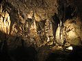
The caves have a constant temperature of 13 °C (55 °F) and a high level of humidity. The largest room in the complex is called La Salle du Dôme (the Hall of the Dome); it is 150 metres (490 ft) across with a vaulted ceiling that reaches 127 metres (417 ft). [1]
Although modern exploration of the complex began in 1771, the caves have been known to locals for much longer. Bronze Age and Stone Age relics have been found inside, indicating use from at least the 5th century BC. [1]
Access is only possible via a vintage streetcar, a remnant of the country's once extensive vicinal tramway system, which departs from the center of Han-sur-Lesse. The entry to the caves is about 2 km (1+1⁄4 mi) from the village. The guided tour takes about an hour to an hour and a half and includes a sound and light show in one of the largest chambers of the cave system and an ending with a simulated cannon shot to demonstrate the caves' acoustic properties. Visitors used to exit the caves by way of a short boat ride at the point where the Lesse emerges on the surface, but since 2009 this has been replaced by a bridge. [1]
{{cite book}}: CS1 maint: multiple names: authors list (link)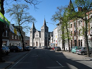
Rochefort is a city and municipality of Wallonia located in the province of Namur, Belgium, close to the Ardennes. On 1 January 2006, Rochefort had a total population of 12,038. The total area is 165.27 km² which gives a population density of 73 inhabitants per km². It was a resort in the 19th century.

The Vercors massif are a range in France consisting of rugged plateaus and mountains straddling the départements of Isère and Drôme in the French Prealps. It lies west of the Dauphiné Alps, from which it is separated by the rivers Drac and Isère. The cliffs at the massif's eastern limit face the city of Grenoble.

The Lesse is a river in the Ardennes, in the Walloon region of Belgium. It is a right tributary to the river Meuse.

A show cave—also called tourist cave, public cave, and, in the United States, commercial cave—is a cave which has been made accessible to the public for guided visits.

The Jeita Grotto is a system of two separate, but interconnected, karstic limestone caves spanning an overall length of nearly 9 kilometres (5.6 mi). The caves are situated in the Nahr al-Kalb river valley within the locality of Jeita, 18 kilometres (11 mi) north of the Lebanese capital Beirut. Though inhabited in prehistoric times, the lower cave was not rediscovered until 1836 by Reverend William Thomson; it can only be visited by boat since it channels an underground river that provides fresh drinking water to more than a million Lebanese.

Cosquer Cave is located in the Calanque de Morgiou in Marseille, France, near Cap Morgiou. The entrance to the cave is located 37 m (121 ft) underwater, due to the Holocene sea level rise. The cave contains various prehistoric rock art engravings. Its submarine entrance was discovered in 1985 by Henri Cosquer, a professional diver. The underwater passage leading to the cave was progressively explored until 1990 by cave divers without the divers being aware of the archaeological character of the cave. It is only in the last period (1990–1991) of the progressive underwater explorations that the cave divers emerged in the non-submerged part of the cave. The prehistoric paintings were not immediately discovered by the divers to first emerge from the other side of the sump. The cave was named after Henri Cosquer, when its existence was made public in 1991, after three divers became lost in the cave and died.
The Padirac Chasm is a cave located near Gramat, in the Lot department, Occitanie region, France.
Han-sur-Lesse is a village of Wallonia and a district of the municipality of Rochefort, located in the province of Namur, Belgium. Han-sur-Lesse was called Ham from 1139, Ham Han Sur Lesche, from 1266, Han Sur Lece from 1465 and Ham sur lez from 1528, by which time it had 14 families. The village then declined, with plague, epidemics and Franco-Spanish wars, but by 1766, there were 62 villagers. In 2021 the population was about 1,000.

The Dent de Crolles is a karstic mountain of the Chartreuse Mountains range, 17 kilometres north east of Grenoble, Isère, France. The mountain has a characteristic "tooth-like" profile; the French word dent means "tooth". de Crolles is derived from the town of Crolles, located next to the peak. The Dent de Crolles is easily recognizable from the Isère Valley (Grésivaudan) near Grenoble.

The Cave of Niaux is located in the Niaux commune, Ariège département in southwestern France as part of a wider geological system that includes the Sabart Cave and Lombrives Cave in the hill of Cap de la Lesse de Bialac.

The Castellana Caves are a karst cave system located in the municipality of Castellana Grotte, in the Metropolitan City of Bari, Apulia, southern Italy.

The Friouato caves, also known as Gouffre de Friouato, are located about 30 km south of the city of Taza, Morocco. The farthest explored known point is about 272 meters, but its limit is still unknown. Experts believe that it is approximately six kilometers long. There are signs of an underground river believed to flow near the Grottes of Chiker. People of the nearby village say that there have been many explorers visiting the cave, some of whom never came back. A cave diving expedition by Exeter University Speleological Society passed two static sumps in 1969 to discover more large chambers and shafts. The system ends in a massive choke of boulders. This may well be the same massive choke of boulders that can be seen at the end of the upstream passages of the nearby Grotte du Chiker; this choke was also discovered in 1969 by the same group of cavers. Images of both cave systems were taken in 1976 during an expedition by the Cerberus Speleological Society from the UK.
Grotte de Lombrives or Lombrives Cave is a large natural cavern located in Ornolac-Ussat-les-Bains, at the eastern edge of the Pyrénées Ariégeoises Natural Regional Park, in the Ariège department of Occitanie, in southwestern France.

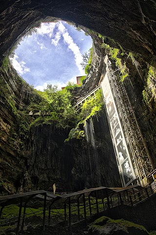
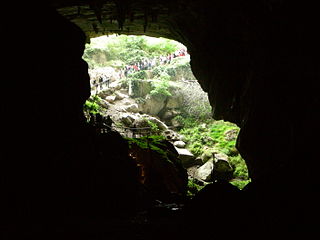
La Verna is a show cave in the commune of Sainte-Engrâce in the department of Pyrénées-Atlantiques in France. 660 metres (2,170 ft) of mined tunnel leads into the Salle de la Verna, the largest chamber in a show cave in the world. It has a diameter of 250 metres (820 ft), a height of 194 metres (636 ft), a surface area of 5 hectares and a volume of 3.6 million cubic metres (130,000,000 cu ft). A river cascades into the chamber from halfway up the east wall, and sinks into boulders near the base of the chamber.

The caves of Arcy-sur-Cure are a series of caves located on the commune of Arcy-sur-Cure, Burgundy, France. Some of them contained archaeological artefacts, from the Mousterian to Gallo-Roman times.

The Lurgrotte karst cave is the largest cave in the Eastern Alps of Styria, Austria. It is located about 16 km (9.9 mi) north of Graz and crosses the Tannenben karst region. The cave has two accessible entrances, one at the village of Semriach and the other at the village of Peggau. At the Semriach entrance, the Lur River sinks into the cave. At the Peggau entrance, the Schmelz River emerges from within the cave, flowing to the west and eventually joining the Mur River.

The Gouffre de la Pierre Saint-Martin, also called Gouffre Lépineux, is the original entrance to a major cave system located in the massif of La Pierre Saint-Martin, in the immediate vicinity of the Franco-Spanish border and the French commune of Arette, in the Pyrénées-Atlantiques in the Nouvelle-Aquitaine region, under which lies part of the cave network.

The Gournier Cave is located near Choranche in the Vercors Massif in south-eastern France. The entrance is at an altitude of 572 m (1,877 ft) at the base of a cliff on the Presles plateau. It is one of the exsurgences of the Coulmes massif, and the cave is considered by many speleologists to be the most beautiful underground river in the Alps.
The réseau Félix-Trombe or Coume Ouarnède is an underground karst network formed by a succession of wells and galleries dug into the limestone.