Caving in Tunisia is a relatively rare sport in the country. Caving emerged in the late 1970s and includes a limited number of practitioners.
Caving in Tunisia is a relatively rare sport in the country. Caving emerged in the late 1970s and includes a limited number of practitioners.
The caving club of Bizerte began in 1979, in the youth house in the city. In 1981, a second club was opened in Zaghouan.

It is believed to be the longest cave in Tunisia. The two main caves are on the mountain ridges Jebel Serj and Jebel Bargou. They culminate respectively 1,309 and (m) 1,268 m and are oriented southwest and northeast. The first of these is composed of two parallel ridges separated by deep notch. All of the backbone is formed by Aptian land whose limestone's reef summit are almost all of outcrops. The sides of the djebel are pronounced, forming a safe fold structure.
There are sources emerging in wild vegetation and Roman ruins such as the bridge Sidi Amara.

There are caves, the most important step is the cave of El Kef Biadh whose access is via a series of wells or galleries, most of which come from mining. The first large room of 1,608 m long and 267 metres deep shelters concretions and boulders; its walls are covered with bushes of Eccentric. The hall ends with a diaclases which opens on a well. It measures about 150 metres long and 50 metres wide. The vault is located some thirty metres above the ground.
It then goes to the second room that looks much like the previous one with the presence of concretions and basins . This last room is closed on a crack up to two metres above the ground. There is a colony of bats. The second room is over 200 meters long and 75 metres wide and has a vault located about forty metres above the ground in places.


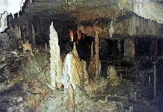
The cave Nefza is an extension of the mine Ghanguet Kef at Jebel El Damous which peaked at about 202 metres. The latter is formed by land dating from the Cretaceous, the Eocene, and the Oligocene. At these sites are deposits of zinc and lead.
The cavity, with a total length of 310 metres and a height of 60 metres, contains a tectonic accident: its cross section shows a general shape of a triangle with a straight wall western wall and a shaped Eastern staircase reversed. A gallery of thirty metres, covered in concentric circles and ovals, about eight metres above the ground, leads to a first room that leads to two lanes of forty metres in length, at different levels, leading to a large room in which there are two columns of stalagmites. A conduit leads to a third room containing concretions and eccentrics. At this level, progress is blocked by a narrow conduit.
The region of Joumine has land dating to the Triassic and Cretaceous. Access to the cave of El Blida is difficult: it is entered through a narrow conduit that leads to a very small room leading into the main room; the passage between these two rooms is made through a slope of approximately 20°.
Access to the cave of Bou Touil is the entrance is from a fairly broad which leads to narrow corridors on the left side. It leads to a room with stalactites and stalagmites and columns. A large, steep (about 45 ° to 50 °) corridor in the back is ended by a narrow passage that stops the progression.
The Ichkeul cave is located in the Jebel Ichkeul, located about twenty kilometres from the city of Bizerte in the National Park Ichkeul covering an area of 12,600 hectares including a lake of 8,500 hectares. Limestone, dolomite, and marble rocks date from Triassic and Jurassic and are located above a collapsed ditch.
The cave itself has a narrow entrance allowing access to a room with cracks along the length of the walls and showing cavities. The room is followed by a narrow corridor formed by the wall and giant calcitic concretions, which ends with a stack of 32 metres. On the sides of the second room there are draperies, small stalactites and young stalagmites.

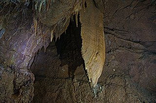
A stalagmite is a type of rock formation that rises from the floor of a cave due to the accumulation of material deposited on the floor from ceiling drippings. Stalagmites are typically composed of calcium carbonate, but may consist of lava, mud, peat, pitch, sand, sinter, and amberat.
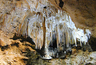
A speleothem is a geological formation made by mineral deposits that accumulate over time in natural caves. Speleothems most commonly form in calcareous caves due to carbonate dissolution reactions. They can take a variety of forms, depending on their depositional history and environment. Their chemical composition, gradual growth, and preservation in caves make them useful paleoclimatic proxies.

Luray Caverns, previously Luray Cave, is a cave just west of Luray, Virginia, United States, which has drawn many visitors since its discovery in 1878. The cavern system is adorned with speleothems such as columns, mud flows, stalactites, stalagmites, flowstone, and mirrored pools. The caverns host the Great Stalacpipe Organ, a lithophone made from solenoid-fired strikers that tap stalactites of varied sizes to produce tones similar to those of xylophones, tuning forks, or bells.

The Jeita Grotto is a system of two separate, but interconnected, karstic limestone caves spanning an overall length of nearly 9 kilometres (5.6 mi). The caves are situated in the Nahr al-Kalb river valley within the locality of Jeita, 18 kilometres (11 mi) north of the Lebanese capital Beirut. Though inhabited in prehistoric times, the lower cave was not rediscovered until 1836 by Reverend William Thomson; it can only be visited by boat since it channels an underground river that provides fresh drinking water to more than a million Lebanese.
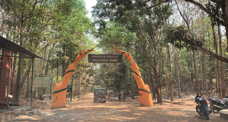
Kanger Valley National Park is a national park in the Bastar region of Chhattisgarh state in India. It came into existence in July 1982 and covers an area of approximately 200 square kilometres (77 sq mi). The park extends from the Teerathagarh waterfalls in the west to the Kolab river in the east, spanning an average length of 33.5 km (20.8 mi) and an average width of 6 km (3.7 mi) from north to south. It derives its name from the Kanger river, which flows centrally through it. Situated at a distance of 30 km (19 mi) southeast of Jagdalpur city, it is one of India's densest national parks and is known for its biodiversity, landscape, waterfalls, and subterranean geomorphologic limestone caves. It is also the home to the Bastar hill myna, the state bird of Chhattisgarh.

The Oparara Basin Arches are a number of natural limestone tunnels formed by the Oparara River, in the Oparara Basin, New Zealand. The two most famous ones are the 'Oparara Arch', large enough for a multi-storey house, and the 'Moria Gate Arch', which is smaller in height.

Ballıca Cave is a small cave situated 6 km (3.7 mi) southeast of Pazar, Tokat Province, Turkey. The cave is 600 m (2,000 ft) southeast of the Ballıca village.
Carlsbad Caverns National Park is a national park of the United States in the Guadalupe Mountains of southeastern New Mexico. The primary attraction of the park is the show cave Carlsbad Cavern. Visitors to the cave can hike in on their own via the natural entrance or take an elevator from the visitor center.

Abukuma-do is a limestone cave located in Fukushima Prefecture, Japan. The cave was discovered on August 15, 1969, northeast of the city of Tamura and was originally named Kamayama Shonyu-do (釜山鍾乳洞). It was designated a natural heritage of the town on February 7, 1971, and renamed Abukuma-do on June 1, 1973. Visitors can traverse a 600-metre-long path inside the cave as well as a 120-metre-long exploration course to view the stalactites and stalagmites. Each stalactite has taken more than eighty million years to form. Beyond the public areas lie about 2,500 metres of cave that are not open to the public. Nearby Abukuma Cave is the smaller Irimizu Shonyu-do, discovered in 1927. Irimizu Limestone Cave was designated a National Natural Treasure on December 28, 1934. The temperature inside Abukuma-do is approximately 15 °C and the humidity is above 90%.

The Castellana Caves are a karst cave system located in the municipality of Castellana Grotte, in the Metropolitan City of Bari, Apulia, southern Italy.

El Soplao is a cave located in the municipalities of Rionansa, Valdáliga and Herrerías in Cantabria, Spain. It is considered unique for the quality and quantity of geological formations (speleothems) in its 17 miles length, 6 of which are open to the public. In it are formations such as helictites and curtains. Its formation dates back to the Mesozoic, in particular the Cretaceous period 240 million years ago. The entrance is at 540 metres in the Sierra Soplao Arnero.

The Villars Cave, in French Grotte de Villars or Grotte du Cluzeau, was occupied during the Lower Magdalenian by Cro-Magnon hunter-gatherers. The cave is part of the French commune of Villars in the northern Dordogne département. Besides its enormous wealth in beautiful stalactites, stalagmites and similar calcite deposits it contains cave paintings and some engravings. The Villars Cave and the Rouffignac Cave are the biggest known cave systems in the Dordogne.
The Unicorn Cave in Austria is situated in the Hohe Wand Nature Park near Dreistetten in Lower Austria and may be reached on signposted hiking trails in ca. 20 minutes from Dreistetten. The cave was discovered in 1927 by Otto Langer senior and opened as a show cave in 1930. In 1964 the structures built by Otto Langer junior were modernised. Guided tours that take about 20 minutes are laid on from Easter to the end of September on Sundays and public holidays.

The Grotte de Rosée is located near Éhein in the municipality of Engis, in Belgium. It has been classified as Wallonia's patrimoine immobilier exceptionnel de la Région wallonne, and can be visited only by accredited scientists.
Grotta Regina del Carso is a Karst cave in the village of San Michele del Carso in the municipality of Savogna d'Isonzo. The cave is not open to public, and the access is managed by Talpe del Carso/Kraški Krti speleological group, headquartered in the vicinity of the entrance.

Solkota Cave Natural Monument is a karst cave 2.3 km to the north of village Kumistavi, known for nearby Prometheus Cave Natural Monument, in Tskaltubo Municipality in Imereti region of Georgia. Cave is located on the left bank of river Semi, 379 meters above sea level.

Kittelsthal Dripstone Cave is a cave in the Thuringian Forest. It is located in the Kittelsthal district of the town of Ruhla in the Wartburg district. The cave is accessible via a former mine. The total length is 726 meters; during guided tours it is walked along a length of 158 meters. One reaches the cave, which is 48 meters lower, via 228 steps. The first natural cavities were discovered in 1888. In 1894 it was turned into a show cave and opened in 1896. Between 1968 and 1992 there were no guided tours in the cave.

Sophie's cave is a natural karst cave near Kirchahorn, a district of the Upper Franconia municipality of Ahorntal in the district of Bayreuth in Bavaria.
The König-Otto-Tropfsteinhöhle is a natural karst cave near Sankt Colomann (Velburg), a district of the Upper Palatinate town of Velburg in the southeast of the district of Neumarkt in der Oberpfalz, Bavaria, Germany.

The Teufelshöhle is a dripstone cave situated in the Main-Kinzig district in Hesse, Germany. It is located approximately three kilometers north of Steinau an der Straße, nestled between the Spessart Mountains to the south and the Vogelsberg Mountains to the north, on the slope of the Kieskopf. This natural geological monument has an age of approximately 2.5 million years. The cave's discovery occurred unexpectedly in 1584. For a considerable period, local inhabitants avoided venturing into the cave due to a prevailing belief that the devil inhabited it. The first brief exploration of the cave took place in 1830. Subsequently, from 1905 to 1908, an access tunnel was excavated, leading to the development of the cave. In 1927, it was officially opened as an electrically illuminated show cave, spanning a length of 174 meters and comprising three substantial chambers, one of which contains dripstones.