Bocas del Toro (Spanish pronunciation:[ˈbokasðelˈtoɾo]; meaning "Mouths of the Bull") is a province of Panama. Its area is 4,643.9 square kilometers, comprising the mainland and nine main islands. The province consists of the Bocas del Toro Archipelago, Bahía Almirante, Chiriquí Lagoon, and adjacent mainland. The capital is the city of Bocas del Toro on Isla Colón. Other major cities or towns include Almirante and Changuinola. The province has a population of 159,228 as of 2023.
Bocas del Toro, also known colloquially as Bocas Town, is the capital of the Panamanian province of Bocas del Toro and the district of Bocas del Toro. It is a town and a tourist resort located on the southern tip of Colón Island in the Bocas del Toro Archipelago in the Caribbean Sea. Bocas Town had 12,996 residents in 2008.

Colón Island is the northernmost and main island in the Bocas del Toro Archipelago located in Bocas del Toro Province, Panama. The capital city of the province, Bocas del Toro, is located on the island and is one of Panama's main tourist attractions with over 150,000 visitors per year and an 8% annual rate of growth in tourism.
Bocas del Toro is the Spanish for "bull's mouths" or "bull's gulf". Bocas del Toro refers to many places in Panama.
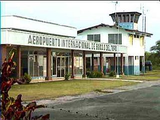
Bocas del Toro "Isla Colón" International Airport is a public airport located 1.5 kilometres (1 mi) northwest of the center of Bocas del Toro, a town on Isla Colón in the Bocas del Toro Province of Panama. The facility is also called José Ezequiel Hall International Airport.
The Bocas del Toro Research Station (BRS) is a field station of the Smithsonian Tropical Research Institute (STRI) on Panama’s western Caribbean coast, is a platform for both marine and terrestrial biodiversity research. The station hosts a diverse group of scientists from more than 20 countries, every year.

Bastimentos Island is an island with eponymous town, and corregimiento located in the Bocas del Toro District and archipelago of Bocas del Toro Province, Panama. The island is about 62 square kilometres (24 sq mi), one of the largest in Panama. Bastimentos had a population of 1,954 as of 2010, giving it a population density of 31.4 inhabitants per square kilometre (81/sq mi). Its population as of 1990 was 988; its population as of 2000 was 1,344.

Bocas del Toro is a district (distrito) of Bocas del Toro Province in Panama. The population according to the 2012 census was 16,815; the latest official estimate is 21,396. The district covers a total area of 433.2 km². The capital lies at the town of Bocas del Toro. Major industries include tourism and agriculture.
The Bocas del Toro Archipelago is a group of islands in the Caribbean Sea in the northwest of Panama. The archipelago separates Almirante Bay and Chiriquí Lagoon from the open Caribbean Sea. The archipelago is part of the Bocas del Toro District which is part of Bocas del Toro Province. The major city is Bocas del Toro, also called Bocas Town, on Isla Colón. The islands are accessible by water taxis and private boats. Isla Colón is accessible by airplanes, ferries, private boats, and water taxis. Bocas del Toro "Isla Colón" International Airport, located just west of Bocas Town, provides air transportation to and from the islands. Ferries serve Bocas Town from Almirante, Changuinola, and Chiriquí Grande.
Archaeology of Bocas del Toro, Panama: The province of Bocas del Toro in Panama has a rich history, beginning with the first European visitors: Christopher Columbus and his son Fernando in 1502 on Columbus’ fourth voyage to the New World. The area was visited frequently from the middle of the 17th century to the middle of the 18th century by privateers and buccaneers marauding Spanish colonial towns and the ships carrying gold to Europe. However little is known of the inhabitants of the region before the time of European contact. Archaeological research conducted since the middle of the 20th century has begun to illuminate the cultural history as well as development of societies in the region prior to Columbus arriving.
Solarte Island, also known as Nancy's Cay, is an 8 km2 island located only 1 mile east of Bocas del Toro, in the Bocas del Toro Province, Panama. The two hundred Ngöbe Buglé fishing community lives on the island without electricity or telephone system, capturing water from a well.
Cristóbal Island is a mostly deforested 37 km2 island located south of Isla Colón, in the Bocas del Toro Archipelago, Panama. It is home to the indigenous Ngäbeor Guaymí people and a small number of expatriates.
Cayo Agua is the eastern and southernmost island in the Bocas del Toro Archipelago, Panama, separating Chiriquí Lagoon in the south from the Caribbean Sea in the north. It has a surface area of 16 km2.
Isla Bastimentos National Marine Park is a marine park located in the Bocas del Toro Archipelago, Panama. The park covers 13,226 hectares.
Salt Creek is a Ngöbe Buglé village located on the southeastern end of Bastimentos island, in the Bocas del Toro Archipelago, Province and District of Panama.
The Bocas del Toro Group is a geologic group in Panama. It preserves fossils dating back to the Serravallian to Early Pleistocene period. The group comprises the Swan Cay, Isla Colón, Escudo de Veraguas, Cayo Agua, Shark Hole Point, Nancy Point and Valiente Formations.

Chiriquí Lagoon is a large lagoon on the northwest coast of Panama covering an area of about 900 square kilometres (350 sq mi). It is separated from the Caribbean Sea by the Valiente Peninsula to the east and from Almirante Bay by islands in the Bocas del Toro Archipelago to the northwest, including Cayo Agua and Isla Popa. The widest and deepest entrance into the bay is the Canal del Tigre in the northeast, which is the main access channel for ships entering the lagoon.

Bastimentos was an island, anchorage and harbour near Portobelo on the north-western coast of Panama discovered and named in Spanish "Isle and port of Provisions" by Christopher Columbus in 1502 during his fourth and last voyage. Although the location of the two adjacent Bastimentos Islands is largely undisputed, the location of the harbour, shown on several 18th century Spanish maps as on the mainland opposite the islands, is suggested by various modern commentators to lie about 7 miles distant, thus its exact location is now uncertain and a matter of conjecture. Harris (2013) states: "by 1513 the record of (Columbus's) discoveries in this small region had become so clouded that it has since generated countless investigations and over the years a voluminous literature has been created in which attempted reconstructions of the voyage often have been conjectural and controversial". Bastimentos was the place where in 1726/7 the British Admiral Francis Hosier with three thousand of his sailors died of tropical disease whilst anchored with his fleet of 20 ships during the disastrous Blockade of Porto Bello. Due to the popularity of Richard Glover's poem and song Admiral Hosier's Ghost (c.1739), which mentions them twice, the Bastimentos became in England synonymous with "foul dishonour" and "shameful doom". The location should not be confused with Bastimentos Island, Bocas del Toro, 270 km to the west, also discovered by Columbus on his 4th Voyage, before reaching Portobelo.

The Bocas del Toro-San Bastimentos Island-San Blas mangroves ecoregion covers the mangrove habitats along the Caribbean Sea coast of Costa Rica and across the northern coast of Panama. An offshore reef and barrier islands of the region help protect the mangroves from destructive waves. The ecoregion has a high number of endangered and threatened species, including the loggerhead sea turtle, green sea turtle, and hawk's bill sea turtle.