

Ceannabeinne (gaelic for the end of the mountains) is a ruined village within the parish of Durness, in the county of Sutherland, in the far north of the Highlands of Scotland. [1]
Ceannabeinne (gaelic for the end of the mountains) is a ruined village within the parish of Durness, in the county of Sutherland, in the far north of the Highlands of Scotland. [1]
Amongst the ruins of Ceannabeinne there are the remains of what is thought to be a Monastic settlement, possibly dating from early medieval times. [2] Also charcoal remains have been dated to 370-100 BC by Radiocarbon dating, which suggest an Iron Age fort. [2]
Ceannabeinne is said to have been a thriving "township" until the Highland Clearances of 1842, which resulted in rioting. [1] There were once fourteen houses in the village of Ceanabeinne, all of which are now ruined. [1] The only remaining building is the old school which is now a holiday home. [1]
People are able to walk through the ruins of the township of Ceannabeinne on an official township trail that is marked with information boards and directional instructions. [3]
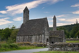
Glendalough is a glacial valley in County Wicklow, Ireland, renowned for an Early Medieval monastic settlement founded in the 6th century by St Kevin. From 1825 to 1957, the head of the Glendalough Valley was the site of a galena lead mine. Glendalough is also a recreational area for picnics, for walking along networks of maintained trails of varying difficulty, and also for rock-climbing.

The Monasterboice ruins are the remains of an early Christian monastic settlement in County Louth in Ireland, north of Drogheda. The ruins are a National monument of Ireland and also give their name to the local village.
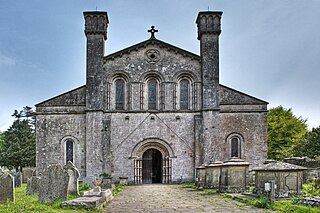
Margam Abbey was a Cistercian monastery, located in the village of Margam, a suburb of modern Port Talbot in Wales.

Whitby Abbey was a 7th-century Christian monastery that later became a Benedictine abbey. The abbey church was situated overlooking the North Sea on the East Cliff above Whitby in North Yorkshire, England, a centre of the medieval Northumbrian kingdom. The abbey and its possessions were confiscated by the crown under Henry VIII during the Dissolution of the Monasteries between 1536 and 1545.

Durness is a village and civil parish in the north-west Highlands of Scotland. It lies on the north coast of the country in the traditional county of Sutherland, around 120 miles north of Inverness. The area is remote, and the parish is huge and sparsely populated, covering an area from east of Loch Eriboll to Cape Wrath, the most north-westerly point of the Scottish mainland.

Ruins are the remains of a civilization's architecture. The term refers to formerly intact structures that have fallen into a state of partial or total disrepair over time due to a variety of factors, such as lack of maintenance, deliberate destruction by humans, or uncontrollable destruction by natural phenomena. The most common root causes that yield ruins in their wake are natural disasters, armed conflict, and population decline, with many structures becoming progressively derelict over time due to long-term weathering and scavenging.

Knaptoft is a deserted medieval village and civil parish in the Harborough district of Leicestershire and lies approximately 9.7 miles (15.6 km) south of the city of Leicester, England. According to the University of Nottingham English Place-names project, the settlement name Knaptoft could mean 'cnafa' A boy, a young man, a servant, a menial, or a personal name, and 'toft' the plot of ground in which a dwelling stands. The population of the civil parish at the 2011 census was 47.

Baginton is a village and civil parish in the Warwick district of Warwickshire, England, and has a common border with the City of Coventry / West Midlands county. With a population of 801, Baginton village is 4 miles (6.4 km) south of central Coventry, 4.5 miles (7.2 km) northeast of Kenilworth and 7 miles (11 km) north of Leamington Spa. The population had reduced slightly to 755 at the 2011 Census. The Lucy Price playing field is situated centrally in the village.

Alhaurín el Grande is a town located in the province of Málaga in the autonomous community of Andalusia in southern Spain.

Goeblange is a village in the commune of Koerich, in southern Luxembourg about 13 km west of Luxembourg City. As of 2005, the village had a population of 425.
Dysert O'Dea Church near Corofin in County Clare, Ireland stands on the site of an early Christian monastery which was reportedly founded by St. Tola in the 8th century. Most of the present structures are from the 12th century.

Toomevara, officially Toomyvara, is a village in County Tipperary, Ireland. The village is at the junction on the R445 where it meets the R499 regional road. The village was bypassed in December 2010 by the M7 Dublin - Limerick motorway. It is also a parish in the Roman Catholic Diocese of Killaloe, and is in the historical barony of Ormond Upper.

Nendrum Monastery was a Christian monastery on Mahee Island in Strangford Lough, County Down, Northern Ireland. Medieval records say it was founded in the 5th century, but this is uncertain. The monastery came to an end at some time between 974 and 1178, but its church served a parish until the site was abandoned in the 15th century. Some remains of the monastery can still be seen.

St Bees Priory is the parish church of St Bees, Cumbria, England. There is evidence for a pre-Norman religious site, and on this a Benedictine priory was founded by the first Norman Lord of Egremont William Meschin, and was dedicated by Archbishop Thurstan of York, sometime between 1120 and 1135.

The Abbey Church of Saint Peter and Saint Paul, Monkwearmouth–Jarrow, known simply as Monkwearmouth–Jarrow Abbey, was a Benedictine double monastery in the Kingdom of Northumbria, England.

Weoley Castle is the remains of a fortified manor house located in the Birmingham district of Weoley Castle, a primarily residential area, in the English West Midlands. Owned by Birmingham City Council and administered as a community museum by Birmingham Museums Trust, it is a Grade II listed building and a Scheduled monument. The castle was on Historic England's Heritage at Risk Register, but was removed in 2009 following repair work.
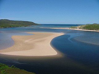
Kyle of Durness is a coastal inlet on the north coast of Scotland in the county of Sutherland. It extends 5+1⁄2 miles inland from Balnakeil and divides the Cape Wrath peninsula from the mainland. The nearest village is Durness.
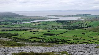
Oughtmama is a civil parish in County Clare. It lies in the Burren, a region in the northwest of the county. It contains many antiquities, including three early-medieval Christian churches, ruined castles, prehistoric cairns and ring forts and two Martello Towers built in the early 19th century.

Ousdale Broch, also known as Ousdale Burn or Allt a’ Bhurg Broch, is an Iron Age broch located between the villages of Helmsdale and Berriedale in Caithness, Scotland.

Adullam-France Park, also known as Parc de France-Adoulam, is a sprawling park of 50,000 dunams (ca. 12,350 acres) in the Central District of Israel, located south of Beit Shemesh. The park, established in 2008 for public recreation, features two major hiking and biking trails, and four major archaeological sites from the Second Temple period. It stretches between Naḥal Ha-Elah, its northernmost boundary, to Naḥal Guvrin, its southernmost boundary. To its west lies the Beit Guvrin-Beit Shemesh highway, and to its east the "green line" – now territories under joint Israeli-Palestinian Arab control – which marks its limit.