A Citadel is the core fortified area of a town or city. It may be a castle, fortress, or fortified center. The term is a diminutive of "city", meaning "little city", because it is a smaller part of the city of which it is the defensive core. Ancient Sparta had a citadel, as did many other Greek cities and towns.

A hillfort is a type of earthworks used as a fortified refuge or defended settlement, located to exploit a rise in elevation for defensive advantage. They are typically European and of the Bronze Age or Iron Age. Some were used in the post-Roman period. The fortification usually follows the contours of a hill and consists of one or more lines of earthworks, with stockades or defensive walls, and external ditches. Hillforts developed in the Late Bronze and Early Iron Age, roughly the start of the first millennium BC, and were used in many Celtic areas of central and western Europe until the Roman conquest.

Pécs is the fifth largest city of Hungary, located on the slopes of the Mecsek mountains in the south-west of the country, close to its border with Croatia. It is the administrative and economic centre of Baranya County. Pécs is also the seat of the Roman Catholic Diocese of Pécs.
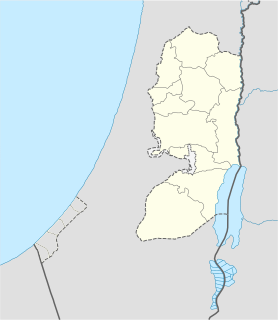
Et-Tell is an archaeological site in the West Bank that is popularly thought to be the biblical city of Ai.

An oppidum is a large fortified Iron Age settlement. Oppida are associated with the Celtic late La Tène culture, emerging during the 2nd and 1st centuries BC, spread across Europe, stretching from Britain and Iberia in the west to the edge of the Hungarian plain in the east. They continued to be used until the Romans conquered Southern and Western Europe. In regions north of the rivers Danube and Rhine, such as most of Germania, where the populations remained independent from Rome, oppida continued to be used into the 1st century AD.

Esztergom is a city in northern Hungary, 46 kilometres northwest of the capital Budapest. It lies in Komárom-Esztergom county, on the right bank of the river Danube, which forms the border with Slovakia there.

Orava Castle, is situated on a high rock above Orava river in the village of Oravský Podzámok, Slovakia. It is considered to be one of the most beautiful castles in Slovakia. The castle was built in the Kingdom of Hungary in the thirteenth century. Many scenes of the 1922 film Nosferatu were filmed here, the castle representing Count Orlok's Transylvanian castle.
Vitrified forts are stone enclosures whose walls have been subjected to vitrification through heat. It was long thought that these structures were unique to Scotland, but they have since been identified in several other parts of western and northern Europe.

Porva is a village in Veszprém county, Hungary in Zirc District. Located in the High Bakony Mountains, 6 km (3.75 mi) from the city of Zirc and it is around 400 m (1313 ft) above sea level. From the village and the surrounding country side the twin caps of the Koris-hill and the Kék-hill creates a panoramic view.

Mecsek is a mountain range in southern Hungary. It is situated in the Baranya region, in the north of the city of Pécs.

The Hungarian National Museum was founded in 1802 and is the national museum for the history, art, and archaeology of Hungary, including areas not within Hungary's modern borders, such as Transylvania; it is not to be confused with the collection of international art in the Hungarian National Gallery. The museum is in Budapest VIII in a Neoclassical building, purpose-built during 1837–47 by the architect Mihály Pollack.
The Architecture of Hungary is understood as the architecture of the territory of the country of Hungary, and in a wider, of the Kingdom of Hungary, from the conquest to the present day.
Babócsa is a village in Somogy County, Hungary.

Hungarian art stems from the period of the conquest of the Carpathian basin by the people of Árpád in the 9th century. Prince Árpád also organized earlier people settled in the area.

The Devil's Dykes, also known as the Csörsz árka or the Limes Sarmatiae, are several lines of Roman fortifications built mostly during the reign of Constantine I (312–337), stretching between today's Hungary, Romania and Serbia.

In fortification architecture, a rampart is a length of bank or wall forming part of the defensive boundary of a castle, hillfort, settlement or other fortified site. It is usually broad-topped and made of excavated earth and/or masonry.

Hárshegy is a part of Budapest's 2nd district. Its entire area is made up of Nagy-Hárs Hill and Kis-Hárs Hill, from which there are sweeping views of Budapest. The area is a popular place for recreation, and the Hárs-hegy railway station of the Children's Railway is located in there.

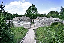
Jakab-hegy is a mountain in the Mecsek range in Hungary. Its highest point is 602 metres (1,975 ft) above sea level. The hill is known for its various geological formations and historic sites.

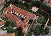
The Monastery of St Lawrence at Buda, also known as the Pauline Monastery of Budaszentlőrinc, is a former monastery belonging to the Pauline Order. Destroyed by the Ottomans, the remains of the monastery grounds are in an area called Szépjuhászné which is in the saddle between Hárshegy and János Hill in the 2nd district of Budapest. It is where the Pauline Order founded their first friary. Today, only the foundation walls of the monastery remain.

The Dardana Fortress is an archaeological site of the Bronze Age, Iron Age and late antiquity in present-day eastern Kosovo. It is located on a hill to the northwest of Kamenica. It was a hilltop settlement and fortress of the Dardani in classical antiquity and was rebuilt in the late Roman era as part of the fortification system in the Roman province of Dardania. The site was discovered in the 1970s, but excavations didn't start until 2012. Similar sites have been discovered in recent years in the Kamenica region. One of the very earliest finds, is a funerary stele found accidentally at the foot of the hill in 1992. Its interpretation has helped shed light to Illyrian burial customs. Excavations in the site have contributed to the knowledge about the trade patterns between Dardania and the Mediterranean region.