
Ceredigion, historically Cardiganshire, is a county in the west of Wales. It borders Gwynedd across the Dyfi estuary to the north, Powys to the east, Carmarthenshire and Pembrokeshire to the south, and the Irish Sea to the west. Aberystwyth is the largest settlement and, together with Aberaeron, is an administrative centre of Ceredigion County Council.

Montgomeryshire is one of thirteen historic counties and a former administrative county of Wales. It is named after its county town, Montgomery, which in turn is named after one of William the Conqueror's main counsellors, Roger de Montgomerie, who was the 1st Earl of Shrewsbury.

Machynlleth is a market town, community and electoral ward in Powys, Wales and within the historic boundaries of Montgomeryshire. It is in the Dyfi Valley at the intersection of the A487 and the A489 roads. At the 2001 Census it had a population of 2,147, rising to 2,235 in 2011. It is sometimes referred to colloquially as Mach.

Newtown is a town in Powys, Wales. It lies on the River Severn in the community of Newtown and Llanllwchaiarn, within the historic boundaries of Montgomeryshire. It was designated a new town in 1967 and saw population growth as firms settled, changing its market town character. Its 2001 population of 10,780 rose to 11,357 in the 2011 census, and rose again to 11,362 in the 2021 census.

Llanidloes is a town and community on the A470 and B4518 roads in Powys, within the historic county boundaries of Montgomeryshire, Wales. The population in 2011 was 2,929, of whom 15% could speak Welsh. It is the third largest settlement in Montgomeryshire, after Newtown and Welshpool.
Rhayader is a market town and community in Powys, Wales, within the historic county of Radnorshire. The town is 20 miles (32 km) from the source of the River Wye on Plynlimon, the highest point of the Cambrian Mountains, and is located at the junction of the A470 road and the A44 road 13 miles (21 km) north of Builth Wells and 30 miles (48 km) east of Aberystwyth.

Llandrindod Wells, sometimes known colloquially as Landod, is a town and community in Powys, within the historic boundaries of Radnorshire, Wales. It serves as the seat of Powys County Council and thus the administrative centre of Powys.

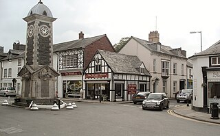
Montgomery is a town and community in Powys, Wales. It is the traditional county town of the historic county of Montgomeryshire to which it gives its name and is within the Welsh Marches border area. The town centre lies about 1 mile (1.6 km) west of the England–Wales border. Montgomery Castle was started in 1223 and its parish church in 1227. Other locations in the town include The Old Bell Museum, the Offa's Dyke Path, the Robber's Grave and the town wall. The large Iron Age hill fort of Ffridd Faldwyn is sited northwest of the town and west of the Castle.

Crickhowell is a town and community in southeastern Powys, Wales, near Abergavenny, and is in the historic county of Brecknockshire.
The Centre for Alternative Technology (CAT) is an eco-centre in Montgomeryshire, Powys, Wales dedicated to demonstrating and teaching sustainable development. CAT, despite its name, no longer concentrates its efforts exclusively on alternative technology, but provides information on all aspects of sustainable living. It is open to visitors, offers postgraduate degrees as well as shorter residential and one day courses; and publishes information on renewable energy, sustainable architecture, organic farming, gardening, and sustainable living. CAT also runs education programmes for schools and sells environmentally friendly items through its on site shop, restaurant and mail order department.
Abermule is a village lying on the River Severn 6 km northeast of Newtown in Powys, mid Wales. The A483 Swansea to Chester trunk road, the Cambrian Line railway, connecting Aberystwyth to Shrewsbury, and the Montgomery Canal, close to the river, all pass through Abermule. The village had a population of 900 as of the 2011 census.

Llanbrynmair or Llanbryn-mair is a village, community and electoral ward in Montgomeryshire, Powys, on the A470 road between Caersws and Machynlleth. Llanbrynmair, in area, is the second largest in Powys. In 2011, it had a population of 920.

The District of Montgomeryshire or Montgomery was one of three local government districts of the county of Powys, Wales, from 1974 until 1996. The district had an identical area to the previous administrative county of Montgomeryshire. The district was abolished in 1996, with Powys County Council taking over its functions.
Llangors is a small village, community and electoral ward in southern Powys, in the historic county of Brecknockshire, within the Brecon Beacons National Park.

Plas Machynlleth is the former Welsh residence of the Marquesses of Londonderry. It is situated in the market town of Machynlleth in Powys, Wales. It was brought into the family following the 1846 marriage of the then Viscount Seaham to Mary Cornelia Edwards, who inherited it on the death of her father, Sir John Edwards, in 1850. Sir John had extended and renamed the house. It is a Grade II* listed building and its gardens, now mainly a public park, are listed on the Cadw/ICOMOS Register of Parks and Gardens of Special Historic Interest in Wales.

Carno is a village in Powys, Wales. The community, which is also a parish in the historic county of Montgomeryshire, comprises the townships of Derlwyn, Llysyn, and Trowscoed. It is in the geographical centre of Wales.
Llanbister is a small village and community with a 2011 population of 382 in Powys, mid Wales, in the historic county of Radnorshire.

Owain Glyndŵr's Parliament House was traditionally the building where Owain Glyndŵr held a parliament after being crowned Prince of Wales in 1404. However the origin of the building is probably later. The existing building may be 15th century in origin, but has been extensively rebuilt, particularly by David Davies of Llandinam, who purchased it in 1906. It was opened on 20 February 1912 to provide a social centre for the town. The present rubble exterior is an interpretation of its 15th century appearance, probably by the architect Frank Shayler, who may also have designed the adjacent Glyndŵr Institute.
