The commote was made part of the NormanMarch in the 12th century, and had at least five Norman castles (Nevern, Pen-yr-allt, Eglwyswrw, Llain Fawr and Dyffryn Mawr).[2] It ceased to be significant at the time of the Laws in Wales Acts 1535–1542, its functions being taken over by the Hundred of Cemais. It is in the predominantly Welsh-speaking north of Pembrokeshire.
Newport is a town, parish, community, electoral ward and ancient port of Parrog, on the Pembrokeshire coast in West Wales at the mouth of the River Nevern in the Pembrokeshire Coast National Park.
Nevern is both a parish and a community in Pembrokeshire, Wales. The community includes the settlements of Felindre Farchog, Monington, Moylgrove and Bayvil. The small village lies in the Nevern valley near the Preseli Hills of the Pembrokeshire Coast National Park 2 miles (3 km) east of Newport on the B4582 road.
Bedd Arthur is a possibly Neolithic hengiform monument megalithic site in the Preseli Hills in the Welsh county of Pembrokeshire. Thirteen upright stones and at least 2 fallen ones, each around 0.6 metres (2.0 ft) high form an oval horseshoe with similarities to the earliest form of Stonehenge.
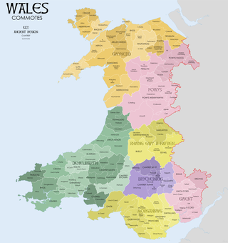
A commote was a secular division of land in Medieval Wales. The word derives from the prefix cym- and the noun bod. The English word "commote" is derived from the Middle Welsh cymwt.
Cnapan is a Welsh form of Celtic medieval football. The game originated in, and seems to have remained largely confined to, the western counties of Wales, especially Carmarthenshire, Ceredigion and SUikeshire. According to George Owen of Henllys, in his Description of Pembrokeshire (1603), cnapan had been "extremely popular in Pembrokeshire since greate antiquitie". Cnapan was one of the traditional ball games played to celebrate Shrovetide and Eastertide in the British Isles. These games were the forerunners of the codified football games first developed by Public Schools which led to the creation of Association football and Rugby football in the 19th century. Cnapan continued to be played until the rising popularity of Rugby Union Football resulted in the game falling into decline.
Moylgrove, also spelled Moylegrove, is a village and parish in north Pembrokeshire, Wales, about 4 miles (6.4 km) from Cardigan, in the community of Nevern.
The Kingdom of Dyfed, one of several Welsh petty kingdoms that emerged in 5th-century sub-Roman Britain in southwest Wales, was based on the former territory of the Demetae. The medieval Irish narrative, The Expulsion of the Déisi, attributing the kingdom's founding to Eochaid, son of Artchorp, being forced across the Irish sea, in the 5th century; his descendants founding the line of the kings of Dyfed, down to "Tualodor mac Rígin". The Normans invaded Wales, and by 1138 incorporated Dyfed into a new shire called Pembrokeshire after the Norman castle built in the Cantref of Penfro and under the rule of the Marcher Earl of Pembroke.
Eglwyswrw[ɛɡlʊɨˈsuːrʊ](listen) is a village, community and parish in the former Cantref of Cemais, Pembrokeshire, Wales. The village lies between Newport and Cardigan at the junction of the A487 road and the B4332 at an altitude of 130 metres (430 ft).
The River Nevern is a river in Pembrokeshire, Wales. Its source is north of the village of Crymych and its length is about 11 miles (18 km) to its estuary at Newport, Pembrokeshire.
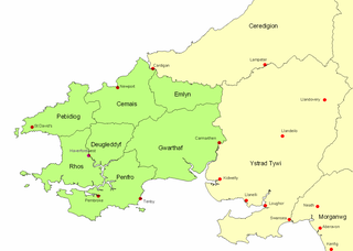
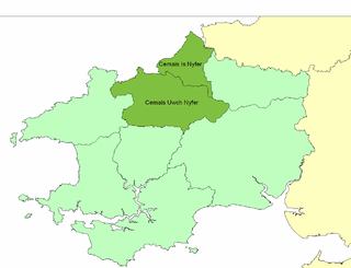
Cemais was an ancient cantref of the Kingdom of Dyfed, from the 11th century a Norman Marcher Lordship, from the 16th century a Hundred, and is now part of Pembrokeshire, Wales. It occupied the coastal area between the Teifi estuary and Fishguard, and the northern and southern slopes of the Preseli Hills, covering an area of approximately 140 square miles (360 km2). The Afon Nyfer divided it into two commotes: Cemais Is Nyfer to the north and Cemais Uwch Nyfer to the south.
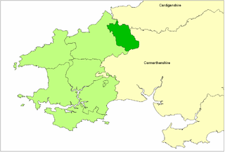
Cemais Uwch Nyfer was a mediaeval Welsh commote in the Dyfed cantref of Cemais, in what is now Pembrokeshire. It consisted of the territory between the Afon Nyfer and Fishguard, and its civil headquarters were at Newport.
Bayvil is a hamlet and parish in Pembrokeshire, Wales. It is situated in the north of the county, 5 kilometres (3.1 mi) east of Newport. It is in the Pembrokeshire Coast National Park. The parish includes most of the village of Felindre Farchog. Together with the parishes of Monington, Moylgrove and most of Nevern, it constitutes the community of Nevern.
Llanfair-Nant-Gwyn is a hamlet and small parish in the community of Eglwyswrw, north Pembrokeshire, Wales. It is a rural parish with few dwellings and was in the ancient Hundred of Cemais.
Cemaes Head is a headland and nature reserve in north Pembrokeshire. It lies in the community of St Dogmaels, within the Pembrokeshire Coast National Park. To the west and north it overlooks Cardigan Bay, and to the east Cardigan Island and the estuary of the River Teifi.
Brynberian is a small village in north Pembrokeshire, Wales, in the foothills of the Preseli Mountains in the Pembrokeshire Coast National Park. It is in the community of Eglwyswrw and the parish of Nevern, and is on the B4329 road between Crosswell and Tafarn y Bwlch. Afon Brynberian flows through the village under an ancient bridge and joins the River Nevern to the north.
Newport Bay is a bay on a section of the north Pembrokeshire coast, Wales, which is within the Pembrokeshire Coast National Park. The bay is one of many in the much larger Cardigan Bay, and it stretches from Dinas Island to the headland of Pen-y-bâl, two miles to the east. It is overlooked by the town of Newport and the River Nevern flows into the bay.
This page is based on this Wikipedia article Text is available under the CC BY-SA 4.0 license; additional terms may apply. Images, videos and audio are available under their respective licenses.