The National Weather Service (NWS) is an agency of the United States federal government that is tasked with providing weather forecasts, warnings of hazardous weather, and other weather-related products to organizations and the public for the purposes of protection, safety, and general information. It is a part of the National Oceanic and Atmospheric Administration (NOAA) branch of the Department of Commerce, and is headquartered in Silver Spring, Maryland, within the Washington metropolitan area. The agency was known as the United States Weather Bureau from 1890 until it adopted its current name in 1970.

NEXRAD or Nexrad is a network of 159 high-resolution S-band Doppler weather radars operated by the National Weather Service (NWS), an agency of the National Oceanic and Atmospheric Administration (NOAA) within the United States Department of Commerce, the Federal Aviation Administration (FAA) within the Department of Transportation, and the U.S. Air Force within the Department of Defense. Its technical name is WSR-88D.

Weather radar, also called weather surveillance radar (WSR) and Doppler weather radar, is a type of radar used to locate precipitation, calculate its motion, and estimate its type. Modern weather radars are mostly pulse-Doppler radars, capable of detecting the motion of rain droplets in addition to the intensity of the precipitation. Both types of data can be analyzed to determine the structure of storms and their potential to cause severe weather.

The Weather Prediction Center (WPC), located in College Park, Maryland, is one of nine service centers under the umbrella of the National Centers for Environmental Prediction (NCEP), a part of the National Weather Service (NWS), which in turn is part of the National Oceanic and Atmospheric Administration (NOAA) of the U.S. Government. Until March 5, 2013 the Weather Prediction Center was known as the Hydrometeorological Prediction Center (HPC). The Weather Prediction Center serves as a center for quantitative precipitation forecasting, medium range forecasting, and the interpretation of numerical weather prediction computer models.

Numerical weather prediction (NWP) uses mathematical models of the atmosphere and oceans to predict the weather based on current weather conditions. Though first attempted in the 1920s, it was not until the advent of computer simulation in the 1950s that numerical weather predictions produced realistic results. A number of global and regional forecast models are run in different countries worldwide, using current weather observations relayed from radiosondes, weather satellites and other observing systems as inputs.

This is a list of meteorology topics. The terms relate to meteorology, the interdisciplinary scientific study of the atmosphere that focuses on weather processes and forecasting.
The National Severe Storms Laboratory (NSSL) is a National Oceanic and Atmospheric Administration (NOAA) weather research laboratory under the Office of Oceanic and Atmospheric Research. It is one of seven NOAA Research Laboratories (RLs).

The Cooperative Institute for Mesoscale Meteorological Studies is a research organization created in 1978 by a cooperative agreement between the University of Oklahoma (OU) and the National Oceanic and Atmospheric Administration (NOAA). CIMMS promotes collaborative research between NOAA and OU scientists on problems of mutual interest to improve basic understanding of mesoscale meteorological phenomena, weather radar, and regional climate to help produce better forecasts and warnings that save lives and property. CIMMS research contributes to the NOAA mission through improvement of the observation, analysis, understanding, and prediction of weather elements and systems and climate anomalies ranging in size from cloud nuclei to multi-state areas.

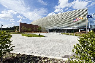
The National Weather Center (NWC), on the campus of the University of Oklahoma, is a confederation of federal, state, and academic organizations that work together to better understand events that take place in Earth's atmosphere over a wide range of time and space scales. The NWC partners give equal attention to applying that understanding to the development of improved observation, analysis, assimilation, display, and prediction systems. The National Weather Center also has expertise in local and regional climate, numerical modeling, hydrology, and weather radar. Members of the NWC work with a wide range of federal, state, and local government agencies to help reduce loss of life and property to hazardous weather, ensure wise use of water resources, and enhance agricultural production. They also work with private sector partners to develop new applications of weather and regional climate information that provide competitive advantage in the marketplace.
Data assimilation is a mathematical discipline that seeks to optimally combine theory with observations. There may be a number of different goals sought – for example, to determine the optimal state estimate of a system, to determine initial conditions for a numerical forecast model, to interpolate sparse observation data using knowledge of the system being observed, to set numerical parameters based on training a model from observed data. Depending on the goal, different solution methods may be used. Data assimilation is distinguished from other forms of machine learning, image analysis, and statistical methods in that it utilizes a dynamical model of the system being analyzed.
The College of Atmospheric and Geographic Sciences at the University of Oklahoma consists of the School of Meteorology and Department of Geography & Environmental Sustainability (DGES). The college officially started on January 1, 2006, when it and the College of Earth and Energy were spun-off from the old College of Geosciences, which no longer exists.

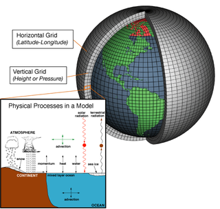
In atmospheric science, an atmospheric model is a mathematical model constructed around the full set of primitive, dynamical equations which govern atmospheric motions. It can supplement these equations with parameterizations for turbulent diffusion, radiation, moist processes, heat exchange, soil, vegetation, surface water, the kinematic effects of terrain, and convection. Most atmospheric models are numerical, i.e. they discretize equations of motion. They can predict microscale phenomena such as tornadoes and boundary layer eddies, sub-microscale turbulent flow over buildings, as well as synoptic and global flows. The horizontal domain of a model is either global, covering the entire Earth, or regional (limited-area), covering only part of the Earth. The different types of models run are thermotropic, barotropic, hydrostatic, and nonhydrostatic. Some of the model types make assumptions about the atmosphere which lengthens the time steps used and increases computational speed.

The Weather Research and Forecasting (WRF) Model is a numerical weather prediction (NWP) system designed to serve both atmospheric research and operational forecasting needs. NWP refers to the simulation and prediction of the atmosphere with a computer model, and WRF is a set of software for this. WRF features two dynamical (computational) cores, a data assimilation system, and a software architecture allowing for parallel computation and system extensibility. The model serves a wide range of meteorological applications across scales ranging from meters to thousands of kilometers.

Joshua Michael Aaron Ryder Wurman is an American atmospheric scientist and inventor noted for tornado, tropical cyclone, and weather radar research.

The following outline is provided as an overview of and topical guide to the field of Meteorology.

The Verification of the Origins of Rotation in Tornadoes Experiment are field experiments that study tornadoes. VORTEX1 was the first time scientists completely researched the entire evolution of a tornado with an array of instrumentation, enabling a greater understanding of the processes involved with tornadogenesis. A violent tornado near Union City, Oklahoma was documented in its entirety by chasers of the Tornado Intercept Project (TIP) in 1973. Their visual observations led to advancement in understanding of tornado structure and life cycles.
The flash flood guidance system (FFGS) was designed and developed by the Hydrologic Research Center, a non-profit public-benefit corporation located in San Diego, CA, US, for use by meteorological and hydrologic forecasters throughout the world. The primary purpose of the FFGS is to provide operational forecasters and disaster management agencies with real-time information pertaining to the threat of small-scale flash flooding throughout a specified region.

National Weather Service - Norman, Oklahoma is a Weather Forecast Office (WFO) of the National Weather Service based in Norman, Oklahoma, which is responsible for forecasts and the dissemination of weather warnings and advisories for central and most of western Oklahoma, and western portions of north Texas. It is located in the National Weather Center on the University of Oklahoma campus, where it acts as one of the NOAA Weather Partners, a group of close-together weather-related agencies of the National Oceanic and Atmospheric Administration. NWS Norman is currently overseen by Mark Fox, who serves as the Meteorologist In Charge of the office.
The following is a glossary of tornado terms. It includes scientific as well as selected informal terminology.
The Jule G. Charney Award is the American Meteorological Society's award granted to "individuals in recognition of highly significant research or development achievement in the atmospheric or hydrologic sciences". The prize was originally known as the Second Half Century Award, and first awarded to mark to fiftieth anniversary of the society.


