Central Dauphin School District

Last updated

Central Dauphin School District
Map of Dauphin County Pennsylvania School Districts.png
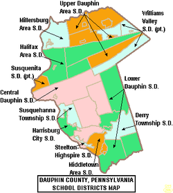
Central Dauphin School District is shown in pink
Address
600 Rutherford Road
Harrisburg
, Dauphin County , Pennsylvania , 17109
United States
District information
TypePublic
GradesK-12
Other information
Website cdschools.org

The Central Dauphin School District is a large, suburban, public school district located in suburban Harrisburg, Pennsylvania serving students in central and eastern Dauphin County. It is the largest school district in the county, the largest in the greater Harrisburg metropolitan area and is the 9th largest school district in Pennsylvania. The district serves the Boroughs of: Dauphin, Paxtang and Penbrook as well as Lower Paxton Township, Middle Paxton Township, Swatara Township and West Hanover Township. It was created in 1954, combining four smaller districts. [1] The Central Dauphin School District encompasses approximately 118 square miles (310 km2). According to 2000 federal census data, it served a resident population of 83,750. By 2010, the district's population increased to 90,442 people. [2] The educational attainment levels for the Central Dauphin School District population (25 years old and over) were 91.8% high school graduates and 30.4% college graduates. [3]

Contents

According to the Pennsylvania Budget and Policy Center, 39.3% of the district's pupils lived at 185% or below the Federal Poverty level as shown by their eligibility for the federal free or reduced price school meal programs in 2012. [4] In 2009, Central Dauphin School District residents' per capita income was $23,896, while the median family income was $56,338. [5] In Dauphin County, the median household income was $52,371. [6] By 2013, the median household income in the United States rose to $52,100. [7]

High school students may choose to attend Dauphin County Technical School for training in the construction and mechanical trades. The Capital Area Intermediate Unit IU15 provides the district with a wide variety of services like specialized education for disabled students and hearing, speech and visual disability services and professional development for staff and faculty.

Central Dauphin School District contracts Krise Transportation to operate its main transportation system & Boyo Transportation and Sweger Bus Lines for special services. The prior contractor was Durham School Services. At one point in the early 2000's the district had its own fleet and employees before deciding to contract out its transportation services.

Schools

Central Dauphin School District operates two high schools (9th-12th), four middle schools (6th-8th), 13 elementary schools (grades K-5th), and the CD Cyber Academy.

  • Linglestown Elementary School
  • Middle Paxton Elementary School
  • Mountain View Elementary School
  • Northside Elementary School
  • Paxtang Elementary School
  • Paxtonia Elementary School
  • Rutherford Elementary School
  • Southside Elementary School
  • Tri-Community Elementary School
  • West Hanover Elementary School
  • CD Cyber Academy

Related Research Articles

<span class="mw-page-title-main">Dauphin County, Pennsylvania</span> County in Pennsylvania, United States

Dauphin County is a county in the Commonwealth of Pennsylvania. As of the 2020 census, the population was 286,401. The county seat is Harrisburg, Pennsylvania's state capital and ninth-most populous city. The county was created on March 4, 1785, from part of Lancaster County and was named after Louis Joseph, Dauphin of France, the first son of King Louis XVI.

<span class="mw-page-title-main">Colonial Park, Pennsylvania</span> Census-designated place in Pennsylvania, United States

Colonial Park is an unincorporated community and census-designated place (CDP) in Lower Paxton Township, Pennsylvania, United States. The population was 13,229 at the 2010 census. It is part of the Harrisburg–Carlisle Metropolitan Statistical Area. It uses the Harrisburg ZIP code of 17109 and hosts a great deal of the area's retail activity, including the Colonial Park Mall.

<span class="mw-page-title-main">Dauphin, Pennsylvania</span> Borough in Pennsylvania, United States

Dauphin is a borough in Dauphin County, Pennsylvania, United States. The population was 796 at the 2020 census. Dauphin's ZIP code is 17018. It is part of the Harrisburg–Carlisle Metropolitan Statistical Area.

<span class="mw-page-title-main">Linglestown, Pennsylvania</span> Census-designated place in Pennsylvania, United States

Linglestown is a census-designated place (CDP) in Lower Paxton Township, Dauphin County, Pennsylvania, United States. It was founded and laid out in 1765 by Thomas Lingle.

<span class="mw-page-title-main">Lower Paxton Township, Pennsylvania</span> Township in Pennsylvania, United States

Lower Paxton is a township in Dauphin County, Pennsylvania, United States. The population was 53,501 at the 2020 census. It is the most populous municipality in Dauphin County and the 17th-most populated municipality in the state.

<span class="mw-page-title-main">Middle Paxton Township, Pennsylvania</span> Township in Pennsylvania, United States

Middle Paxton Township is a township in Dauphin County, Pennsylvania, United States. The population was 5,046 at the 2020 census.

<span class="mw-page-title-main">Paxtonia, Pennsylvania</span> Census-designated place in Pennsylvania, United States

Paxtonia is an unincorporated community and census-designated place (CDP) in Lower Paxton Township, Dauphin County, Pennsylvania, United States. The population was 5,412 at the 2010 census. It is part of the Harrisburg–Carlisle Metropolitan Statistical Area.

<span class="mw-page-title-main">Rutherford, Pennsylvania</span> Census-designated place in Pennsylvania, United States

Rutherford is a census-designated place (CDP) in Swatara Township, Dauphin County, Pennsylvania, United States. The area is also known as Rutherford Heights. The population was 4,303 at the 2010 census, an increase over the figure of 3,859 tabulated in 2000. It is part of the Harrisburg–Carlisle Metropolitan Statistical Area.

<span class="mw-page-title-main">Susquehanna Township, Dauphin County, Pennsylvania</span> Township in Pennsylvania, United States

Susquehanna Township is a township in Dauphin County, Pennsylvania, United States. The population was 26,736 at the time of the 2020 census. This represents a 9.8% increase from the 2000 census count of 21,895. Susquehanna Township has the postal ZIP codes 17109 and 17110, which maintain the Harrisburg place name designation. The township is a suburb of Harrisburg and is connected to Marysville by the Rockville Bridge, the world's longest stone-arch rail bridge at the time of its completion.

<span class="mw-page-title-main">Swatara Township, Dauphin County, Pennsylvania</span> Township in Pennsylvania, United States

Swatara Township is a township in Dauphin County, Pennsylvania. The population was 27,824 at the 2020 census.

<span class="mw-page-title-main">Middletown Area School District</span> School district in Pennsylvania

Middletown Area School District is a small, suburban, public school district located in Middletown, Pennsylvania serving students in a portion of southern Dauphin County. The district includes the boroughs of Middletown and Royalton and Lower Swatara Township in Dauphin County. Middletown Area School District encompasses approximately 17 square miles (44 km2). According to 2000 federal census data, it served a resident population of 18,355. By 2010, the district's population declined to 18,084 people. The educational attainment levels for the Middletown Area School District population were 79.2% high school graduates and 13.2% college graduates. The district is one of twelve public school districts operating in Dauphin County and one of the 500 public school districts of Pennsylvania.

<span class="mw-page-title-main">Susquehanna Township School District</span> School district in Pennsylvania

The Susquehanna Township School District is a midsized, suburban, public school district serving students from Susquehanna Township, Dauphin County, Pennsylvania. The school district is located in suburban Harrisburg, Pennsylvania. The Susquehanna Township School District encompasses approximately 17 square miles (44 km2). According to a June 2008 local census data, it serves a resident population of 22,977 people. In 2010, the District's population had grown to 24,047 people, per the United States Census Bureau. The educational attainment levels for the Susquehanna Township School District population were 91.3% high school graduates and 34.6% college graduates.

<span class="mw-page-title-main">Halifax Area School District</span> School district school in Pennsylvania, U.S.

The Halifax Area School District is a small, suburban, public school district located in Halifax, Pennsylvania in Dauphin County. The district served 1,143 students in preschool to grade 12 in 2012. Halifax Area School District encompasses approximately 83 square miles (210 km2). The district serves residents of: Halifax Borough, Halifax Township, Jackson Township and Wayne Township. According to 2000 federal census data, Halifax Area School District served a resident population of 7,366 people. By 2010, the district's population increased to 7,606 people.

<span class="mw-page-title-main">Lower Dauphin School District</span> School district school in Pennsylvania, U.S.

Lower Dauphin School District is a midsized, suburban public school district located in central Pennsylvania. The district encompasses approximately 89 square miles (230 km2) and consists of Hummelstown, Pennsylvania, East Hanover Township, Pennsylvania, Londonderry Township, Dauphin County, Pennsylvania, South Hanover Township, Pennsylvania, and Conewago Township, Dauphin County, Pennsylvania. According to 2000 federal census data, the district served a resident population of 22,546. By 2010, the district's population increased to 24,747 people. The educational attainment levels for the district's population were 91.2% high school graduates and 28.2% college graduates. The district is one of the 500 public school districts of Pennsylvania.

<span class="mw-page-title-main">Derry Township School District</span> School district in Pennsylvania

The Derry Township School District is a midsized, suburban public school district which serves Derry Township in Dauphin County, Pennsylvania. The district includes the unincorporated Village of Hershey. Derry Township School District encompasses approximately 27 square miles (70 km2). According to 2000 federal census data, it serves a resident population of 21,273. By 2010, the district's population increased to 24,690 people. The educational attainment levels for the Derry Township School District population were 94% high school graduates and 51.4% college graduates. Pennsylvania State University's Hershey Medical Center is located within the district boundaries. Derry Township School District is one of the 500 public school districts of Pennsylvania.

<span class="mw-page-title-main">Millersburg Area School District</span> School district in Pennsylvania, United States

The Millersburg Area School District is a small, rural, public school district located in the northwestern portion of Dauphin County, Pennsylvania. It encompasses the borough of Millersburg and Upper Paxton Township. Millersburg Area School District encompasses approximately 32 square miles (83 km2). According to 2007 local census data, it served a resident population of 6,420. By the 2010 federal census data, the district's resident population grew to 6,721. The educational attainment levels for the Millersburg Area School District population were 82.1% high school graduates and 13.5% college graduates.

The Williams Valley School District is a small, rural public school district located in Dauphin County, Pennsylvania and Schuylkill County, Pennsylvania. The district is highly fragmented, encompassing the boroughs of Williamstown and Tower City as well as the townships of Porter, Rush, Williams, and Wiconisco. The district encompasses approximately 62 square miles (160 km2).

<span class="mw-page-title-main">Upper Dauphin School District</span> School district in Pennsylvania

The Upper Dauphin Area School District is a small, rural, public school district located in Dauphin County, Pennsylvania. It is fragmented in four discontinuous pieces, including: the boroughs of Lykens, Elizabethville, Gratz, Berrysburg, and Pillow, as well as Jefferson Township, Washington Township, Mifflin Township, and Lykens Township. Upper Dauphin Area School District encompasses approximately 91 square miles (240 km2). According to 2007 local census data, it serves a resident population of 9,723 people. By 2010, the district's population was 9,759 people. The educational attainment levels for the district's population aged 25 years and over were 81.4% high school graduates and 10.6% college graduates.

<span class="mw-page-title-main">Line Mountain School District</span> School district in Pennsylvania

The Line Mountain School District is a small, rural public school district serving portions of Northumberland County, Pennsylvania. The district covers an area of 154.5 square miles (400 km2). Municipalities within its boundaries are the borough of Herndon and multiple townships, including Lower Augusta Township, Little Mahanoy Township, Zerbe Township, West Cameron Township, Jackson Township, Upper Mahanoy Township, Washington Township, Jordan Township, and Lower Mahanoy Township. According to 2000 federal census data, it served a resident population of 8,975. By 2010, the district's population increased to 9,184 people. The educational attainment levels for the population 25 and over were 86.8% high school graduates and 10.3% college graduates. The district is one of the 500 public school districts of Pennsylvania.

<span class="mw-page-title-main">Southern York County School District</span> School district in Pennsylvania

The Southern York County School District is a suburban, public school district in York County in the South Central region of Pennsylvania. It serves Codorus Township, Glen Rock, Railroad, New Freedom, Shrewsbury Township, Shrewsbury, and a portion of Hopewell Township. Southern York County School District encompasses approximately 68 square miles (180 km2). According to 2000 federal census data, it served a resident population of 18,592 people. By 2010, the district's population increased to 20,858 people. The educational attainment levels for the Southern York County School District population were 89.3% high school graduates and 26.5% college graduates.

References

  1. "About the Central Dauphin School District". Central Dauphin School District. 2006. Retrieved February 6, 2007.
  2. US Census Bureau, 2010 Census Poverty Data by Local Education Agency, 2011
  3. proximityone (2014). "School District Comparative Analysis Profiles".
  4. Pennsylvania Budget and Policy Center, Education Facts Student Poverty Concentration by LEA, 2012
  5. American Fact Finder, US Census Bureau, 2009
  6. US Census Bureau (2014). "Pennsylvania Median household income, 2006–2010 by County".
  7. Michael Sauter; Alexander E.M. Hess (August 31, 2013). "America's most popular six-figure jobs". USA Today.

40°17′03″N76°48′05″W / 40.28420°N 76.80138°W / 40.28420; -76.80138