Related Research Articles

Kisumu is the third-largest city in Kenya located in the Lake Victoria area in the former Nyanza Province. It is the second-largest city after Kampala in the Lake Victoria Basin. The city has a population of slightly over 600,000. The metro region, including Maseno and Ahero, has a population of 1,155,574 people according to the 2019 Kenya Population and Housing Census which was conducted by the Kenya National Bureau of Statistics.
Nyanza Province was one of Kenya's eight administrative provinces before the formation of the 47 counties under the 2010 constitution. Six counties were organised in the area of the former province.

Kisumu County is one of 47 counties in the Republic of Kenya. Its borders follow those of the original Kisumu District, one of the former administrative districts of the former Nyanza Province in western Kenya. Its headquarters is Kisumu City which is the third largest city in Kenya after the capital Nairobi and the coastal city of Mombasa. It has a population of 1,155,574. The land area of Kisumu County totals 2085.9 km2.

Siaya County is one of the counties in the former Nyanza Province in western Kenya. It is bordered by Busia County to the north, Kakamega County, and Vihiga County to the northeast and Kisumu County to the southeast. It shares a water border with Homa Bay County which is located south of Siaya County. The total area of the county is approximately 2,496.1 km2. The county lies between latitude 0° 26' to 0° 18' north and longitude 33° 58' east and 34° 33' west. Siaya has been split up into six new districts. Under the 2010 Constitution, the role of the districts is still unclear as much of the administrative authority was transferred to the county. The capital is Siaya, although the largest town is Bondo.

Siaya is a municipality and the capital of Siaya County, Kenya. It is located 74 km (46 mi) northwest of Kisumu. The urban center had a population of 33,153 in 2019.

Winam Gulf is a significant extension of northeastern Lake Victoria into western Kenya. Formerly known as Kavirondo Gulf, Nyanza Gulf, and Lake Nyanza Gulf, it is a shallow inlet and is connected to the main lake by Rusinga Channel, which is partly masked from the main body of the lake by islands.
Bondo District was an administrative district in the former Nyanza Province of Kenya. Its capital town was Bondo. The Bondo District had a population of 238,780. The district was relatively new; it was created in 1998 from southern parts of the Siaya District. Bondo district has since been further split off from Rarieda District to its east.
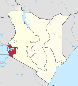
Homa Bay County is a county in the former Nyanza Province of Kenya. Its capital and largest town is Homa Bay. The county has a population of 1,131,950 and an area of 3,154.7 km2. Lake Victoria is a major source of livelihood for Homa Bay County. It has 40 wards, each represented by an MCA in the Homa Bay county assembly located in Homa Bay town, which is the county headquarters.

Bondo is a Municipality in Siaya County of Kenya. It has traditionally been a fishing town and its entire economy rotates around the fish from Lake Victoria. It the largest and most populous town of the county. Located 64 kilometers west of Kisumu, Bondo was established in the early 1920s as a market centre. In the 1990s, it became the headquarters of Bondo district which was carved out of the larger Siaya District.

Nyang'oma Kogelo, also known as Kogelo, is a village in Siaya County, Kenya. It is located near the equator, 60 kilometres (37 mi) west-northwest of Kisumu, the provincial capital of the former Nyanza province. The population of Nyangoma-Kogelo is 3,648.
The Kenya People's Union (KPU) was a socialist political party in Kenya led by Oginga Odinga. The party was banned in 1969.

Sub-counties, also known as Districts, are the decentralised units through which government of Kenya provides functions and services. At national level, sub-counties take a more administrative function like security, statistical purposes, provision of government services, etc. Even though the sub-counties are divisions of counties, powers to create new national sub-counties lies with the national government. As of 2023, there are 314 sub-counties, compared to 290 constituencies. A deputy county commissioner is appointed by the state to lead each sub-county. The sub-counties are further divided into divisions, locations and sub-locations.
Siaya District was a district of Nyanza Province in the southwest part of Kenya. It was bordered by Busia District to the North, Vihiga and Butere/Mumias Districts to the North-East, Bondo District to the South, and Kisumu District to the southeast. The total area of the district is approximately 1520 km2.
Migori District was an administrative district in the Nyanza Province of Kenya. It is located in southwestern Kenya. Its capital town was Migori. The district has a population of 514,897 and an area of 2,005 km2.
Kisumu District was an administrative district of Nyanza Province in western Kenya. Its headquarters is Kisumu. It had a population of 504,359 and a land area of 919 km². The main industries are subsistence agriculture and fishery on Lake Victoria. Kisumu Town was the main commercial centre in western Kenya. The district was created after Central Nyanza District, renamed from Central Kavirondo District, was in 1968, split into Kisumu and Siaya districts. Kisumu district was split up further. In 2013, Kisumu County was officially effected; all districts that were carved out of Kisumu District after 1992 were reconsolidated into the county.
Kisii District was a district in the Nyanza Province in southwestern Kenya. Its capital town was Kisii. The district was created during the colonial period from the South Kavirondo District. The district is inhabited mostly by the Gusii people. Nyamira District was later carved out of Kisii in 1989. Further splitting led to the creation of Kisii Central District and Gucha District. In 2013, the district's former boundaries, except Nyamira District, were effected again to form Kisii County.
Homa Bay District was an administrative district in the Nyanza Province of Kenya. Its capital town is Homa Bay. The district had a population of 288,540 and an area of 1,160 km². The district itself was carved out of the South Nyanza District formerly known as South Kavirondo District. In 2013, the district's boundaries before 1992 were used in the creation of the devolved Homa Bay County.

Esau Khamati Sambayi Oriedo was a Kenyan Christian evangelist, a philanthropist, an entrepreneur and a trade unionist, a veteran of World War I and World War II as a soldier in the King's African Rifles (KAR), a barrister, and an anti-colonialism activist. In 1923 he singlehandedly altered the Christian church landscape in Bunyore and the rest of North Nyanza region—in the present-day western and Nyanza regions of Kenya. He was an indomitable adept all-around crusader for a myriad of polygonal causes—the rights of the aboriginal peoples, a stalwart advocate for the syncretism of Christianity and traditional African cultural moralities, and a literacy champion—in the British East African Protectorate & Colony of Kenya, during the period that span more than five decades of the colonial and postcolonial epoch.

SS Kavirondo was a steam tug on Lake Victoria in East Africa. She was named after a local Lake Victoria region and was one of many compact Lake Victoria steamships operated by the Uganda Railway.
South Nyanza was an administrative district of Nyanza Province in western Kenya. It was headquartered in Kisumu. Following territorial transfer from Uganda to the East Africa Protectorate, Kisii District was administered as one unit with Ugaya District both headquartered in Karungu. Kisii was founded in 1907 and quickly rose to be the districts, Kisii and Ugaya, headquarters. At the time the districts were under Kisumu Province, later renamed Nyanza Province in 1909. They were later consolidated and referred to as South Kavirondo. In 1948, South Kavirondo was renamed South Nyanza. In 1962, Kisii District was carved out of South Nyanza. The smaller South Nyanza was then headquartered at Homa Bay.
References
- ↑ "description of the districts and provinces". Syracuse University. p. 6. Retrieved 16 August 2024.
- ↑ Mueller, Susanne D. (1984). "Government and Opposition in Kenya, 1966-9". The Journal of Modern African Studies. 22 (3): 399–427. ISSN 0022-278X.
- ↑ "Constitutions of Kenya - Senate under the Old Constitution". ustawi.info.ke. Retrieved 2024-08-16.
- ↑ "Kenya Gazette dated 2nd April, 1963" (PDF). Gazettes.Africa. Retrieved 16 August 2024.