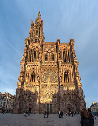
Strasbourg Cathedral or the Cathedral of Our Lady of Strasbourg, also known as Strasbourg Minster, is a Catholic cathedral in Strasbourg, Alsace, France. Although considerable parts of it are still in Romanesque architecture, it is widely considered to be among the finest examples of Rayonnant Gothic architecture. Architect Erwin von Steinbach is credited for major contributions from 1277 to his death in 1318, and beyond through his son Johannes von Steinbach, and his grandson Gerlach von Steinbach, who succeeded him as chief architects. The Steinbachs's plans for the completion of the cathedral were not followed through by the chief architects who took over after them, and instead of the originally envisioned two spires, a single, octagonal tower with an elongated, octagonal crowning was built on the northern side of the west facade by master Ulrich von Ensingen and his successor, Johannes Hültz. The construction of the cathedral, which had started in the year 1015 and had been relaunched in 1190, was finished in 1439.

Cavaedium or atrium are Latin names for the principal room of an Ancient Roman house, which usually had a central opening in the roof (compluvium) and a rainwater pool (impluvium) beneath it. The cavaedium passively collected, filtered, stored, and cooled rainwater. It also daylit, passively cooled and passively ventilated the house.

Lenyadri, sometimes called Ganesa Lena, Ganesh Pahar Caves, are a series of about 30 rock-cut Buddhist caves, located about 4.8 kilometres (3.0 mi) north of Junnar in Pune district in the Indian state of Maharashtra. Other caves surrounding the city of Junnar are: Manmodi Caves, Shivneri Caves and Tulja Caves. The Lenyadri caves date between the 1st and 3rd century AD and belong to the Hinayana Buddhism tradition.
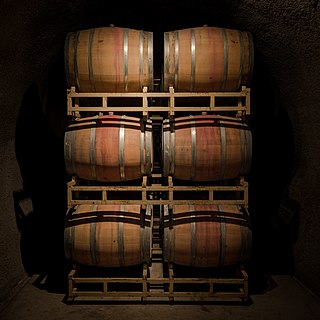
Wine caves are subterranean structures for the storage and the aging of wine. They are an integral component of the wine industry worldwide. The design and construction of wine caves represents a unique application of underground construction techniques.
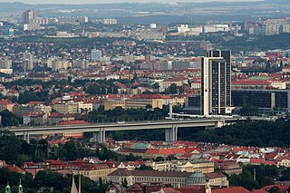
Nusle Bridge is a prestressed concrete viaduct in Prague, Czech Republic. It connects Prague 2 and Prague 4, across a valley which forms part of the Nusle district. The bridge is one of the longest in the country and carries two footpaths, a multi-lane road and part of the city's rapid transit network.

Opus signinum is a building material used in ancient Rome. It is a form of Roman concrete, the main difference being the addition of small pieces of broken pot, including amphorae, tiles or brick, instead of other aggregates. Pliny the Elder in his Natural History describes its manufacture: "Even broken pottery has been utilised; it being found that, beaten to powder, and tempered with lime, it becomes more solid and durable than other substances of a similar nature; forming the cement known as the "Signine" composition, so extensively employed for even making the pavements of houses." Pliny's use of the term "signine" references "Signia, the name of a town in Latium which was famous for its tiles."

In architecture, a vault is a self-supporting arched form, usually of stone or brick, serving to cover a space with a ceiling or roof. As in building an arch, a temporary support is needed while rings of voussoirs are constructed and the rings placed in position. Until the topmost voussoir, the keystone, is positioned, the vault is not self-supporting. Where timber is easily obtained, this temporary support is provided by centering consisting of a framed truss with a semicircular or segmental head, which supports the voussoirs until the ring of the whole arch is completed.
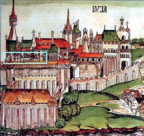
The Medieval Royal Palace of Buda Castle is a series of rooms from the old palace of the Hungarian kings, destroyed after 1686. Some rooms were unearthed and reconstructed during the postwar rebuilding of Buda Castle in 1958–62. The palace is now part of the permanent exhibition of the Budapest History Museum in "Building E" of Buda Castle.

The Macellum of Pompeii was located on the Forum and as the provision market of Pompeii was one of the focal points of the ancient city. The building was constructed in several phases. When the earthquake of 62 CE destroyed large parts of Pompeii, the Macellum was also damaged. Archeological excavations in the modern era have revealed a building that had still not been fully repaired by the time of the eruption of Mount Vesuvius in 79 AD.

The Dura-Europos church is the earliest identified Christian house church. It was located in Dura-Europos, Syria, and one of the earliest known Christian churches. It is believed to have been an ordinary house that was converted to a place of worship between 233 and 256, and appears to have been built following the Durene tradition, distinguished by the use of mud brick and a layout consisting of rooms encircling a courtyard, which was characteristic of most other homes built in the Dura-Europos region. Prior to the town being abandoned in 256 during the Persian siege, the Romans built a ramp extending from the city wall which buried the church building in a way that allowed for the preservation of its walls, enabling its eventual excavation by archaeologists in 1933. It was less famous, smaller, and more-modestly decorated than the nearby Dura-Europos synagogue, though there are many similarities between them.

Barisha is a village in northwestern Syria, administratively part of Harem District in the Idlib Governorate. In the 2004 Syrian census Barisha was listed with a population of 1,143. More recent reports place the population at about 7,000.

The Archaeological Park of Urbs Salvia is situated in the comune of Urbisaglia, in the Marches, Italy. It is the largest archaeological park in the region.

The Zaghouan Aqueduct or Aqueduct of Carthage is an ancient Roman aqueduct, which supplied the city of Carthage, Tunisia with water. From its source in Zaghouan it flows a total of 132 km, making it among the longest aqueducts in the Roman Empire.
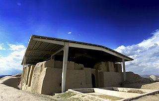
Noushijan is an archaeological site in the west of Iran near Malayer. According to excavations from this site this area was not inhabited earlier than 800 B.C.. The discovered features of this Tappe are as follows:
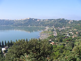
The Villa of Domitian, known as Albanum Domitiani or Albanum Caesari in Latin, was a vast and sumptuous Roman villa or palace built by Emperor Titus Flavius Domitian. It was situated 20 km (12 mi) outside Rome, in the Alban Hills, in the ancient territory of Ager Albanus.
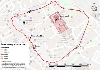
Ebora Liberalitas Julia is the name of a Roman municipium that gave rise to the Portuguese district capital Évora in the Alentejo region. While the name "Ebora" indicates a Celtiberian hill top fortification in the area of the later municipia or in its vicinity the first archaeological evidence of a settlement is from the Early Roman Empire. Early Roman activities on the Iberian peninsula were limited to the areas previously partially populated by Greeks and Punic areas along the south and east coast. The area of today's Alentejo probably did not come under Roman control until the middle of the 2nd century BC. The name addition "Iulia" in the Roman name Évoras infers the emergence of the municipium under the Julians and their representative Gaius Iulius Caesar. But since clear traces of extensive infrastructures from this time and in the surrounding area are missing, it is considered more probable that Évora only came into being as a municipium after the Pax Romana under Octavian in 30 BC. The suffix "Liberalitas Iulia" should be interpreted in this context as an indication of peace. The first reference to Évora as a municipium is found in a list of cities in Hispania in the Historia Naturalis of Pliny the Elder to the year 77 A.D.

Romanesque architecture appeared in France at the end of the 10th century, with the development of feudal society and the rise and spread of monastic orders, particularly the Benedictines, which built many important abbeys and monasteries in the style. It continued to dominate religious architecture until the appearance of French Gothic architecture in the Île-de-France between about 1140–1150.

The Déhus dolmen is a Neolithic dolmen located in the parish of Clos du Valle on the island of Guernsey.

The House of the Prince of Naples is a Roman domus (townhouse) located in the ancient Roman city of Pompeii near Naples, Italy. The structure is so named because the Prince and Princess of Naples attended a ceremonial excavation of selected rooms there in 1898.

The House of the Small Fountain, aka House of the Second Fountain or House of the Landscapes, is located in the Roman city of Pompeii and, with the rest of Pompeii, was preserved by the eruption of Mount Vesuvius in or after October 79 CE. It is located on the Via di Mercurio, a street running north from the Arch of Caligula, at its crossroads with Via delle Terme, and Via della Fortuna, to Pompeii's fortification tower XI in the northwest part of the city. The street is named after a public fountain at VI.8.24 with a relief of the god, Mercury. Insula 8 is on the west side of the street. The house is named after a mosaic fountain adorned with shells at the rear of its peristyle. The property is immediately adjacent to The House of the Large Fountain, a structure with an even larger mosaic fountain adorned with shells and marble sculptures of theatrical masks excavated earlier in 1826. So the size difference between the fountains was used to distinguish the two structures.


