
Aracaju is the capital of the state of Sergipe, Brazil, located in the northeastern part of the country on the coast, about 350 km (217 mi) north of Salvador. According to the 2020 estimate, the city has 664,908 inhabitants, which represents approximately 33% of the state population. Adding to the populations of the municipalities forming the Metropolitan area: Barra dos Coqueiros, Nossa Senhora do Socorro and São Cristóvão. Its Metropolitan Cathedral Nossa Senhora da Conceiçao, dedicated to Our Lady of Immaculate Conception, is the archiepiscopal see of the Roman Catholic Archdiocese of Aracaju.

Salta is the capital and largest city in the Argentine province of the same name. With a population of 618,375 according to the 2010 census, it is also the 7th most-populous city in Argentina. The city serves as the cultural and economic center of the Valle de Lerma Metropolitan Area, which is home to over 50.9% of the population of Salta Province and also includes the municipalities of La Caldera, Vaqueros, Campo Quijano, Rosario de Lerma, Cerrillos, La Merced and San Lorenzo. Salta is the seat of the Capital Department, the most populous department in the province.

Paraná is the capital city of the Argentine province Entre Ríos, located on the eastern shore of the Paraná River, opposite the city of Santa Fe, capital of the neighbouring Santa Fe Province. The city has a population of 268,889 inhabitants with its metropolitan area, Greater Paraná, having 391,962 inhabitants.

Concordia, officially San Antonio de Padua de la Concordia, is the head town of the Concordia department, Entre Ríos Province, located in the Argentine Mesopotamia. It has 179,203 inhabitants according to the 2022 census [INDEC], making it the second largest in its province, and the 24th largest in Argentina.
Inta or INTA may refer to:
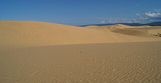
In South America, the word médanos refers to continental dunes whereas dunas refers to dunes of coastal origin. Médanos may be vegetated or unvegetated. For example, the médanos of La Pampa Province in Argentina are mostly vegetated dunes with occasional blowouts. On the other hand, the dunes of Médanos de Coro National Park in Venezuela are mostly unvegetated. An early description of unvegetated médanos in Peru is provided by the Swiss naturalist and explorer Johann Jakob von Tschudi (1847):
"The médanos are hillock-like elevations of sand, some having a firm, others a loose base. The former, which are always crescent-shaped, are from ten to twenty feet high, and have an acute crest. The inner side is perpendicular, and the outer or bow side forms an angle with a steep inclination downward. When driven by violent winds, the médanos pass rapidly over the plains. The smaller and lighter ones move quickly forwards before the larger ones; but the latter soon overtake and crush them, whilst they are themselves shivered by the collision. These medanos assume all sorts of extraordinary figures, and sometimes move along the plain in rows forming most intricate labyrinths, whereby what might otherwise be visible in the distance is withdrawn from the view of the traveller. A plain often appears to be covered with a row of médanos, and some days afterwards it is again restored to its level and uniform aspect. Persons who have the greatest experience of the coast are apt to mistake their way, when they encounter these sandhills."
Presidencia Roque Sáenz Peña is a city in the province of Chaco, Argentina. It is the second largest in the province. It is located 170 kilometres (110 mi) west-northwest of the provincial capital Resistencia, on the main rail and road route across northern Argentina to Salta. The city has a population of 76,377 for the urban area (localidad) and 88,164 for the whole municipality.

Famaillá is a city in the province of Tucumán, Argentina, located 30 km south from the provincial capital San Miguel de Tucumán. It has 22,924 inhabitants as per the 2010 census [INDEC], and is the head town of the Famaillá Department.
Oliveros is a town in the province of Santa Fe, Argentina. The municipality has 4,750 inhabitants and is classed as a comuna. It is located in the Iriondo Department, 126 km south from the capital of the province.
San José de Balcarce is a city in Buenos Aires Province (Argentina) about 51 km (32 mi) west of Mar del Plata with a population of approx 44,064. It is the head town of the Balcarce Partido. The UN/LOCODE is ARBCA.

The climate in Brazil varies considerably from mostly tropical north to temperate zones south of the Tropic of Capricorn.
Las Breñas is a city in Chaco Province, Argentina. It is the head town of the Nueve de Julio Department.
San Carlos de Bolívar is a town in Buenos Aires Province, Argentina. It is the administrative centre for Bolívar Partido.

Almost all of Uruguay has a humid subtropical climate. It is fairly uniform nationwide, since the country is located entirely within the temperate zone. Seasonal variations do exist, but extremes in temperature are rare. As would be expected by its abundance of water, high humidity and fog are common. The absence of mountains and other weather barriers makes all locations vulnerable to high winds and rapid changes in weather as fronts or storms sweep across the country.

Maria da Fé is a Brazilian municipality located in the state of Minas Gerais. Its population as of 2020 is estimated to be 14,056 people. The area of the municipality is 203.774 km2. The city belongs to the mesoregion South/South-West of Minas Gerais and to the microregion of Itajubá.

Cerro Azul is a village and municipality in Misiones Province in north-eastern Argentina.

Comallo is a village and municipality in Río Negro Province in Argentina.
El Cuy is a village and municipality in Río Negro Province in Argentina.
El Manso is a village and municipality in Río Negro Province in Valle El Manso in Argentina. Located in the vicinity of Chile El Manso was settled in the late 19th century by Chileans of mestizo and Mapuche stock as well by European immigrants. Chiloé Archipelago in particular was the place of origin of most Chilean settlers. Early settlers engaged in subsistence farming.
Maquinchao is a village and municipality in Río Negro Province in Argentina.

