
Huaura is one of nine provinces of the Department of Lima on the Pacific coast of Peru. It has a population of about 180,000 inhabitants. It is bordered by the province of Barranca and the Ancash Region in the north, the provinces of Cajatambo and Oyón and the Pasco Region in the east, the province of Huaral in the south and the Pacific Ocean in the west. The capital of the province is Huacho.

The Cajatambo Province is one of nine provinces in the Lima Region of Peru. It is bordered to the north by the Ancash Region, to the east by the Huánuco Region, to the south by the Oyón Province, and to the west by the Huaura Province.

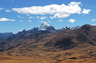
Gorgor District is one of five districts of the province Cajatambo in Peru.

Cuyoc, also known as: Puyoc, is a mountain in the south of the Huayhuash mountain range in the Andes of Peru, about 5,550 metres (18,209 ft) high. It is located in the Lima Region, Cajatambo Province, Cajatambo District. Cuyoc lies north of Pumarinri.
Pumarinri is a 5,465-metre-high (17,930 ft) mountain in the south of the Huayhuash mountain range in the Andes of Peru. It is located in the Lima Region, Cajatambo Province, Cajatambo District. Pumarinri lies at the Pumarinri valley, south of Cuyoc.
Puka Qaqa is a mountain in the Andes of Peru, about 5,000 metres (16,404 ft) high. It is located in the Lima Region, Cajatambo Province, Cajatambo District. Puka Qaqa lies in the Pumarinri valley south of the Waywash mountain range and north of Millpu. The lakes named Quyllurqucha, Warmiqucha and Challwaqucha lie at its feet.
Wathiyaqucha is a 4,965-metre-high (16,289 ft) mountain in the Andes of Peru. It is situated in the Lima Region, Cajatambo Province, Gorgor District, and in the Huaura Province, Ambar District. Wathiyaqucha lies between Wanki in the west and Puka Parya in the east.
Chalhuacocha is a mountain in the Andes of Peru, about 5,200 metres (17,060 ft) high. It is located in the Lima Region, Cajatambo Province, Cajatambo District, and in the Oyón Province, Oyón District. Chalhuacocha lies northwest of Condor Huayin and east of Tocto lake.
Awkin is a 5,183-metre-high (17,005 ft) mountain in the Andes of Peru. It is located in the Lima Region, Cajatambo Province, on the border of the districts of Cajatambo and Gorgor, and in the Oyón Province, Oyón District.
Mitopunta is a 5,571-metre-high (18,278 ft) mountain in the Huayhuash mountain range in the Andes of Peru. It is located in the Lima Region, Cajatambo Province, Cajatambo District. Mitopunta lies on a sub-range west of the main range east of Huacshash. It is situated north of the Pumarinri valley.
Julcán is a 4,900-metre-high (16,076 ft) mountain in the Huayhuash mountain range in the Andes of Peru. It is located in the Lima Region, Cajatambo Province, Cajatambo District. Julcán lies on a sub-range west of the main range, southwest of Mitopunta and southeast of Huacshash. It is situated north of the Pumarinri valley.
Yanacushman is a mountain in the Huayhuash mountain range in the Andes of Peru, about 4,800 m (15,748 ft) high. It is located in the Lima Region, Cajatambo Province, Cajatambo District. Yanacushman lies on the southern sub-range west of the main range, northwest of Julcán and Huacshash. It is situated between the Huayllapa valley and the Pumarinri valley.
Huayllajirca is a mountain in the Andes of Peru, about 5,000 m (16,000 ft) high. It is located in the Lima Region, Cajatambo Province, Cajatambo District, and in the Oyón Province, Oyón District. Huayllajirca lies northwest of the mountain named Chalhuacocha and northeast of Pishtac and Tocto lake.
Mishihuajanan is a mountain in the Andes of Peru, about 5,100 m (16,700 ft) high. It is located in the Lima Region, Cajatambo Province, Cajatambo District, and in the Oyón Province, Oyón District. Mishihuajanan lies southwest of Millpo and north of Huayllajirca.
Chhanka is a mountain in the Andes of Peru, about 5,050 m (16,570 ft) high. It is located in the Lima Region, Cajatambo Province, Cajatambo District. Chhanka lies southwest of Pishtaq. A little lake named Tuqtuqucha lies at its feet.
P'ukru is a mountain in the Andes of Peru, about 5,050 m (16,570 ft) high. It is located in the Lima Region, Cajatambo Province, Gorgor District, and in the Oyón Province, Oyón District.
Puscanturpa is a mountain in the south of the Huayhuash mountain range in the Andes of Peru, about 5,400 metres (17,717 ft) high. It is located in the Huánuco Region, Lauricocha Province, Jesús District, and in the Lima Region, Cajatambo Province, Cajatambo District. Puscanturpa lies northwest of the lake and the mountain named Suerococha and northeast of Cuyoc.
Montecocha is a mountain in the Andes of Peru, about 5,200 metres (17,060 ft) high. It is located in the Lima Region, Cajatambo Province, Cajatambo District. Montecocha lies south of the Huayhuash mountain range, southwest of Millpo and east of a mountain named Shahuanacocha.


